|
The 2006 Hurricane Season got off to an early start. Tropical Storm Alberto, the first named storm of the season, made landfall along the Florida Big Bend coast northwest of Adams Beach in Taylor County at approximately 1230 PM EDT, Tuesday, June 13. This was roughly 40-50 miles southeast of Tallahassee, FL. As can be seen in Figure 1 (below), a large area of convection developed on the west side of the center during the period surrounding landfall, prompting a Flash Flood Warning to be issue by this office for portions of Talyor and Madison Counties.
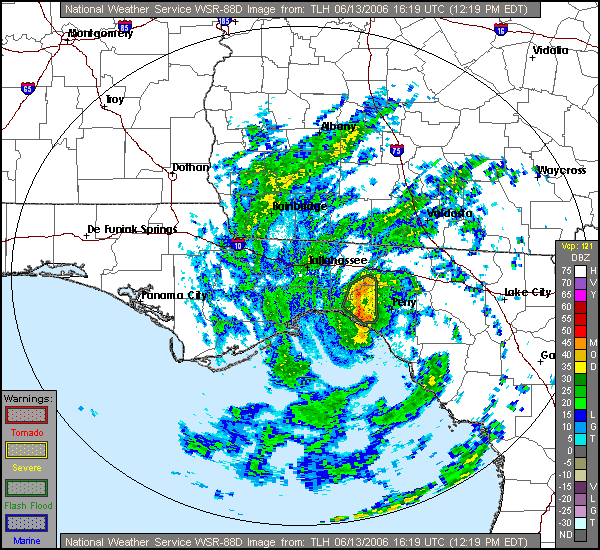
Figure 1. Doppler radar base reflectivity image from the KTLH Doppler radar valid 1619 UTC (1219 PM EDT) 13 June 2006 showing Tropical Storm Alberto near the time of landfall along the Florida Big Bend coast. The Flash Flood Warning area is outlined.
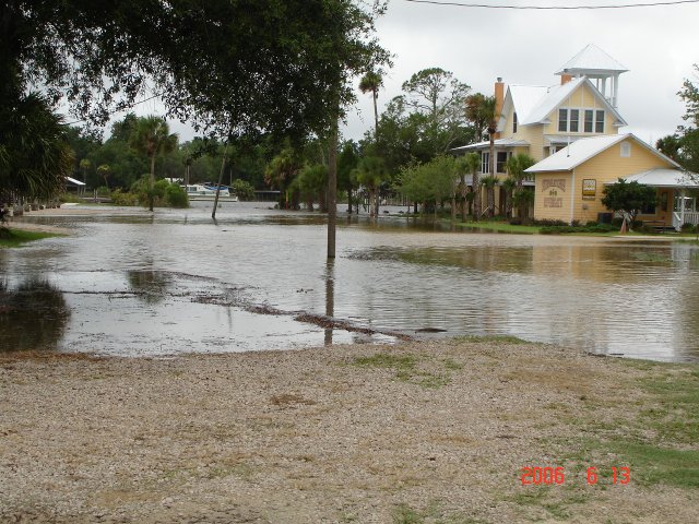
Areas south of the storm track over southern Taylor and Dixie Counties saw some storm surge flooding from Alberto. Figure 2 shows a graph from the tide gage at Cedar Key, FL. The blue line is the predicted astronomical tide; the red x's represent observed water levels, and the green line shows the residual, or departure from normal astronomical tide. Departures peaked at about 4 feet above normal. Fortunately this occurred during the low tide. Some of the worst flooding occurred on Horseshoe Beach in Dixie County, FL. Figure 3 shows a photograph taken in Horseshoe Beach during the peak of tidal flooding there on the afternoon of the 13th. Figure 4 shows windy conditions and rough surf on the beach near Steinhatchee, FL, near the Taylor-Dixie County border. Figures 5 and 6 show storm surge flooding in Steinhatchee.
Alberto produced minimal structural damage due to tropical storm force wind gusts across the Florida Big Bend. Many parts of the Big Bend and South Central Georgia picked up 3-5 inches of rain. However, antecedent conditions were so dry that no widespread areal or riverine flooding resulted. Additional information on T.S. Alberto is available in our Preliminary Storm Report.
In case you're wondering, this is not the first time a tropical storm named Alberto impacted this area. Back in 1994, T.S. Alberto came ashore in the Florida Panhandle and then did a slow loop once it reached West Central Georgia, causing catestrophic flooding. More information on the Alberto of '94 can be found here.
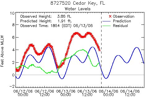
Figure 2. A graph from the tide gage at Cedar Key, FL. The blue line is the predicted astronomical tide; the red x's represent observed water levels, and the green line shows the residual, or departure from normal astronomical tide.
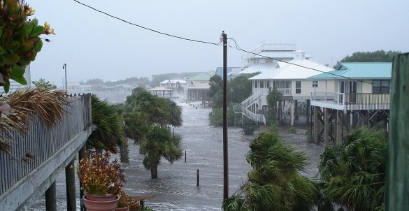
Figure 3. Photo of storm surge flooding at Horseshoe Beach, FL, associated with T.S. Alberto on the afternoon of Tuesday, 13 June 2006.
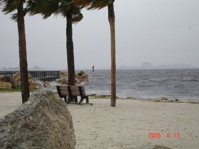
Figure 4. Photo of windy conditions and rough surf on the beach near Steinhatchee, FL, near the Taylor-Dixie County border.

Figures 5 and 6. Storm surge flooding in Steinhatchee, FL during T.S. Alberto.
|