|
There are currently no active tropical cyclones in the Atlantic or Eastern Pacific.
The 2008 Atlantic hurricane season will be an ongoing event in the annual cycle of tropical cyclone formation. The season will officially start on June 1 and will run through November 30. These dates conventionally delimit the period of each year when most tropical cyclones form in the Atlantic basin.
Seasonal Forecast
Forecasts of hurricane activity are issued before each hurricane season by noted hurricane experts Dr. Philip J. Klotzbach, Dr. William M. Gray, and their associates at Colorado State University; and separately by NOAA forecasters. Dr. Klotzbach's team defined the average number of storms per season (1950 to 2000) as 9.6 tropical storms, 5.9 hurricanes, and 2.3 major hurricanes (storms exceeding Category 3 strength in the Saffir-Simpson Hurricane Scale). A normal season, as defined by NOAA, has 9 to 12 named storms, with 5 to 7 of those reaching hurricane strength, and 1 to 3 major hurricanes.
|
| Source |
Date |
Named |
Hurricanes |
Major |
| CSU |
1950–2000 |
9.6 |
5.9 |
2.3 |
| NOAA |
1950–2005 |
11.0 |
6.2 |
2.7 |
| |
Record high |
28 |
15 |
8 |
| |
Record low |
4 |
2 |
0 |
|
| CSU |
7 Dec 2007 |
13 |
7 |
3 |
| CSU |
9 Apr 2008 |
15 |
8 |
4 |
| NOAA |
22 May 2008 |
12–16 |
6–9 |
2–5 |
|
| |
Actual activity |
- |
- |
- |
|
2008 Storm Names
The following names will be used for named storms that form in the North Atlantic in 2008. Retired names, if any, will be announced by the World Meteorological Organization in the spring of 2009. The names not retired from this list will be used again in the 2014 season. The list is the same as the 2002 list except for Ike and Laura which will replace Isidore and Lili, respectively.
- Arthur
- Bertha
- Cristobal
- Dolly
- Edouard
- Fay
|
- Gustav
- Hanna
- Ike
- Josephine
- Kyle
|
- Laura
- Marco
- Nana
- Omar
- Paloma
|
- Rene
- Sally
- Teddy
- Vicky
- Wilfred
|
Add our selection of weather gadgets to your favorite portal page
and stay ahead of the weather!
|
|
 |
The Hurricane Atlantic Analysis map show the current surface features (highs, lows, fronts, tropical cyclones) in the Atlantic Ocean.
|
 |
The Hurricane Tropical Winds map shows high level (about 40,000 feet) wind speed and direction over the Atlantic Ocean for the past 24 hours.
|
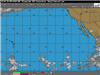 |
The Hurricane Pacific Analysis map shows the current and forecast positions of any active tropical cyclones in the central and eastern Pacific Ocean.
|
|
 |
The Hurricane Atlantic Satellite map shows clouds by their temperature over the Atlantic Ocean. Red and blue areas indicate cold (high) cloud tops.
|
 |
The Hurricane Caribbean Satellite map shows clouds by their temperature over the Caribbean Sea. Red and blue areas indicate cold (high) cloud tops.
|
 |
Maps displayed are infrared (IR) images. Warmest (lowest) clouds are shown in white; coldest (highest) clouds are shown in shades of yellow, red, and purple.
|
|
|
|
More Areas of Interest
|
Storm Center
 |
Maps displaying current National Weather Service Watches, Warnings and Advisories via County Fill colors.
|
 |
Current National Weather Service Watches and Warnings by type and state throughout the United States.
|
|
|
|

|