|
This is the SRTM home page. The Shuttle Radar Topography Mission
(SRTM) obtained elevation data on a near-global scale to generate the
most complete high-resolution digital topographic database of Earth.
SRTM consisted of a specially modified radar system that flew onboard the
Space Shuttle Endeavour during an 11-day mission in February of 2000.
SRTM is an international project spearheaded by the National Geospatial-Intelligence Agency (NGA) and the National Aeronautics and Space Administration
(NASA).
SRTM Publication
An edited version of "The Shuttle Radar Topography Mission, Rev. Geophys., 45, RG2004, doi:10.1029/2005RG000183" was
recently released. Please go to the SRTM Bibliography for further information
SRTM Accuracy Report
JPL has released the full SRTM accuracy report. It's available in the
SRTM Bibliography. A condensed version will be
published in the March 2006 issue of Photogrammetric Engineering and
Remote Sensing, which is devoted to SRTM.
SRTM V2 released
NASA has released version 2 of the Shuttle Radar Topography Mission
digital topographic data (also known as the "finished" version).
Version 2 is the result of a substantial editing effort by the
National Geospatial Intelligence Agency and exhibits well-defined
water bodies and coastlines and the absence of spikes and wells
(single pixel errors), although some areas of missing data ('voids')
are still present. The Version 2 directory also contains the vector
coastline mask derived by NGA during the editing, called the SRTM
Water Body Data (SWBD), in ESRI Shapefile format.
The data may be obtained by anonymous ftp to: ftp://e0srp01u.ecs.nasa.gov
and moving to the directory srtm where both version 1 and version 2
directories may be found. Please read the appropriate documentation,
also found in the directories.
Australia Data Release
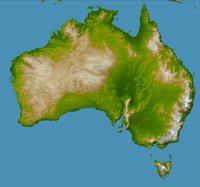
NASA has released the SRTM data set for Australia, New Zealand, and
numerous South Pacific islands. There are about 1200 data 'cells' in
this release, each measuring one by one degree of latitude and
longitude. They represent the final set of unedited data from the
SRTM mission to be released.
As with the other SRTM data for regions outside the United States the
new set is sampled at 3 arc-seconds, which is 1/1200th of a degree
of latitude and longitude, or about 90 meters (295 feet). Because of
persistent cloud cover many of the Pacific islands had previously been
very poorly mapped, if at all.
The new data are available for download from the USGS EROS Data Center
- see Public Data Distribution
for details.
|