
|
||
|
|
||
| View other datasets |
|
|
| ||
 |
|||
| Coverage of this dataset spans January 2001 to February 2006. | |||
The animation features of the Earth Observatory are currently unavailable. We apologize for the inconvenience. To view the full temporal span of this dataset, please view the Cirrus Cloud Fraction monthly holdings. | |||
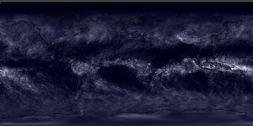
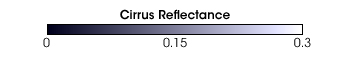 Product description: Cirrus are thin, high-altitude clouds that can sometimes be hard to see with the unaided eye. They are scientifically interesting because they allow most incoming sunlight to pass through them, but they help to contain heat emitted from the surface, thereby exerting a warming influence. The MODIS sensor has a unique band for measuring infrared light at a wavelength of 1.38 micrometers -- a wavelength that scientists recently found is highly sensitive to cirrus. In the image above, bright white pixels indicate regions completely covered by cirrus clouds. Greyish-white pixels show partial cirrus cover and dark pixels indicate little or no cirrus. The image above represents the average cirrus cloud fraction over the Earth for the month indicated. Image courtesy Reto Stockli, Earth Observatory, based upon data provided by the MODIS Science Team, NASA Goddard Space Flight Center.
|
|
Subscribe to the Earth Observatory About the Earth Observatory Contact Us Privacy Policy and Important Notices Responsible NASA Official: Lorraine A. Remer Webmaster: Goran Halusa We're a part of the Science Mission Directorate |