HOME | ABOUT US | CONTACT | REGIONAL MANAGERS
 
  Research & Development  
 
  Experimental Products / Prototypes  
     •   BookletChart™ (Experimental)  
     •   Water Level and Current Forecast Guidance  
 
  Hydrographic Support  
     •   Autonomous Underwater Vehicles (AUV)  
     •   Remotely Operated Vehicles (ROV)  
     •   Phase Differencing Bathymetric Sonar  
     •   Sound Velocity Profiler  
     •   Tidal Corrector Application (TCARI)  
 
  Products and Database Development  
     •   Bathymetric Warehouse  
     •   Coast Pilot Relational Database  
     •   VDatum Enhancements  
     •   Coastal Digital Elevation Models  
     •   Operational Data Acquisition & Archiving System  
     •   Live Access Server for Hydrodynamic Model Output  
     •   nowCOAST  
 
  Coastal & Estuarine Ocean Modeling  
     •   Forecast System Modeling  
     •   Inundation Modeling  
     •   Ecological Modeling Applications  
     •   Community Modeling & Standards  
     •   Model Evaluation Environment  
 
  Learn About  
     •   Coast Survey Development Laboratory  
     •   Hydrographic Survey Equipment  
     •   Datums and Transformations  
     •   How Hydrodynamic Models Are Used  
 
  Resources  
     •   Technical Reports & Publications  
     •   Coast Survey Partners  
     •   Standards and Requirements  
 
  Data Portals  
     •   nowCOAST: Real-Time Coastal Data Map Portal  
     •   Tides and Currents (General)  
     •   Physical Oceanographic Real-Time System (PORTS)  
     •   Operational Forecast Systems  
     •   Sea Nettle Forecast Guidance  
     •   North American Horizontal Datum Conversion Utility  
     •   University of New Hampshire, Joint Hydrographic Center  
 

Water Level and Current Forecast Guidance


Experimental Water Level and Current Forecast Guidance
A forecast system developed for the Columbia River at Oregon Health and Sciences University is currently being tested, skill assessed and prepared for transition. New systems are being developed in CSDL for the Delaware Bay and River, for Tampa Bay, FL, and an experimental system is being run pseudo-operationally for the Gulf of Mexico (the National Ocean Service Gulf of Mexico Model (NGOM)). Also under development is a 2nd Generation Chesapeake Bay Experimental Forecast System.  The existing CBOFS is based on a two-dimensional barotropic model that provides forecast guidance on water levels only (no currents); however, CBOFS will be upgraded to a fully three-dimensional, baroclinic model in the near-future in order to provide additional forecast guidance on currents, temperature and salinity.

EXPERIMENTAL FORECAST MODELING SYSTEMS

 Click on the box you want to view.

 DESCRIPTION

FORECAST
GUIDANCE

 Columbia River Experimental Forecast System (CREFS)


 ▄

 Delaware Bay Experimental Forecast System (DBEFS)


 NA

 Tampa Bay Experimental Forecast System (TBEFS)


 NA

 2nd Generation Chesapeake Bay Experimental Forecast System (CBEFS2)

 NA

 National Ocean Service Gulf of Mexico Model (NGOM)


         NGOM Short-Term Forecasts  

NA

         NGOM Long-Term Forecasts  

NA


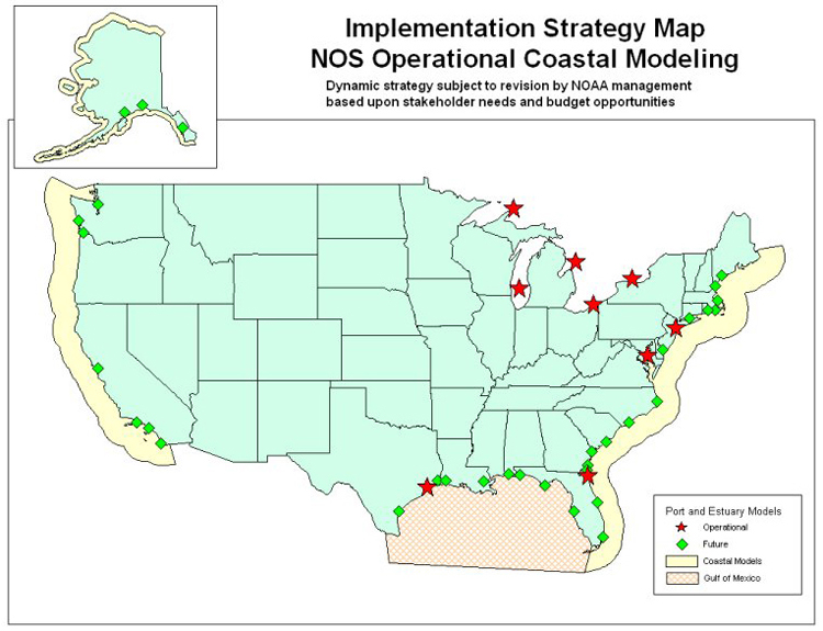
Future Locations of Development
Forecast systems will be operationally implemented in the future for numerous other ports, estuaries and coastal regions, depending primarily on the user needs and requirements of the marine navigation and emergency response communities. Systems are being considered for Cook Inlet, AK; San Francisco Bay, CA; and for numerous locations along the Gulf of Mexico coast. In addition, upgrades to existing operational forecast systems will be necessary. A map of potential operational forecast system locations is shown below.

Map of U.S. showing coastal waters with Implementation Strategy Map for NOS Operational Coastal Modeling locations.  Operational and future sites are shown along the coastal areas of U.S.

Privacy Policy  |  Disclaimer  |  NOAA's National Ocean Service  |  NOAA  |  U.S. Department of Commerce