Water Resources of Arkansas

Man holding a fish

Mississippi Embayment Regional Aquifer Study

As part of the USGS Ground-Water Resources Program, a ground-water flow model of the northern Mississippi embayment will be developed using data and knowledge gained from the Gulf Coast Regional Aquifer System Analysis (GCRASA) studies and other more recently completed USGS models to aid in answering questions about ground-water availability.
Hands holding a fish

Ozark NAWQA Study Unit

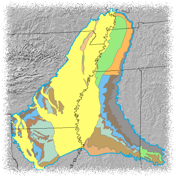
The Ozark Plateaus NAWQA is one of more the 50 study units that are part of the U.S. Geological Survey's National Water-Quality Assessment (NAWQA) Program. The Ozark Plateaus study unit is approximately 48,000 square miles in size and includes parts of northern Arkansas, southeastern Kansas, southern Missouri, and northeastern Oklahoma.
Sparta Intake

Sparta Recovery Project

The Sparta aquifer is Union County's only source of municipal and industrial ground water. Since development began in the early 1920's ground-water levels have declined more than 390 feet in some areas. As a result, Union was among five southern Arkansas counties designated as the state's first "Critical Ground Water Area" in 1996.

USGS Home Water Resources Biology Geography Geology Geospatial Program

Accessibility FOIA Privacy Policies and Notices

Take Pride in America home page. FirstGov button U.S. Department of the Interior | U.S. Geological Survey
URL: http://ar.water.usgs.gov/features.html
Page Contact Information: GS-W-AR_webmaster@usgs.gov
Page Last Modified: Monday, 18-Aug-2008 14:39:15 CDT btj