| TEXT ONLY VERSION | NATIONAL
HURRICANE CENTER |
 |
 |
|
The graph shows that the sustained winds in a hurricane will decrease at a relatively constant rate (approximately half the wind speed in the first 24 hours). Therefore, the faster the forward speed of a landfalling hurricane, the further the inland penetration of hurricane force winds. |
|
|
Visit these websites to learn more |
|

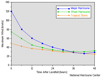 The
graph to the right shows how wind speed rapidly decreases once a tropical cyclone
reaches land. Part of the reason for this is that the roughness of the terrain
increases friction, slowing the air. Another reason is that, once the storm
is over land, it is usually cut off from the heat and moisture sources that
sustain it. However, wind gusts (as opposed to the sustained winds shown in
the graph) may actually increase because the greater turbulence over land mixes
faster air to the surface in short bursts.
The
graph to the right shows how wind speed rapidly decreases once a tropical cyclone
reaches land. Part of the reason for this is that the roughness of the terrain
increases friction, slowing the air. Another reason is that, once the storm
is over land, it is usually cut off from the heat and moisture sources that
sustain it. However, wind gusts (as opposed to the sustained winds shown in
the graph) may actually increase because the greater turbulence over land mixes
faster air to the surface in short bursts.