|
Deep-Water Northern
Gulf of Mexico Hydrocarbon Plays
Robert H. Peterson and David W. Cooke
Minerals Management Service,United States
Department of the Interior, New Orleans, LA
Abstract
The geologic setting in the deep-water (depths > 305 meters {1,000 feet}) Gulf of
Mexico is very favorable for the existence of large, commercial hydrocarbon accumulations.
These areas have active salt tectonics that create abundant traps, underlying mature
Mesozoic source rocks that can be observed expelling oil and gas to the ocean surface, and
good quality reservoirs provided mainly by submarine fan deposits. Despite the limited
amount of drilling in the deep-water Gulf of Mexico, 11 deep-water accumulations have been
discovered which, when developed, will rank in the top 100 largest fields in the Gulf of
Mexico. Proved field discoveries have added over 1 billion barrels of oil equivalent to
Gulf of Mexico reserves, and unproved field discoveries may add an additional billion
barrels of oil equivalent.
The Minerals Management Service of the United States Department of the Interior, has
completed a gulf-wide review of over 1,086 oil and gas fields and placed every pay sand in
each field into one of several hydrocarbon plays. Plays are defined by chronostratigraphy,
lithostratigraphy, structure, and production. Seven productive hydrocarbon plays include
reservoirs located in the deep-water northern Gulf of Mexico. Regional maps illustrate the
productive limits of each play. In addition, field data, dry holes, and wells with
sub-economic pay were added to define the facies and structural limits for each play.
Areas for exploration potential are identified for each hydrocarbon play. A type field for
each play is chosen to demonstrate the play's characteristics.
 |
Documents that have this symbol are in Adobe Acrobat's pdf format.
These files can be downloaded, read and printed using the free Acrobat Reader. |
The following figures correspond to the figures referenced in the Complete Text
above:
| Figure 1. |
Map of proved fields and new discoveries in deep-water fields, northern Gulf of
Mexico. |
| Figure 2. |
Miocene, Pliocene and Pleistocene Fan Play summary. |
| Figure 3. |
Stratigraphic Subdivisions and Chronozones of the Miocene, Pliocene and Pleistocene |
| Figure 4. |
Sand Classification System. |
| Figure 5. |
Upper Pleistocene Fan Plays Map |
| Figure 5a. |
Graph showing recoverable in place hydrocarbons (BOE) for the ten largest pools in the
upper Pleistocene Fan Plays. Pools from deep-water fields are outlined. |
| Figure 6. |
Middle Pleistocene Fan Plays Map. |
| Figure 6a. |
Graph showing recoverable in place hydrocarbons (BOE) for the ten largest pools in the
middle Plesitocene Fan Plays. Pools from fields in deep-water are outlined. |
| Figure 7. |
Lower Pleistocene Fan Play Map. |
| Figure 7a. |
Graph showing recoverable in place hydrocarbons (BOE) for the ten largest pools in the
lower Pleistocene Fan Plays. Pools from fields in deep-water are outlined. |
| Figure 8. |
Upper Pliocene Fan Play Map. |
| Figure 8a. |
Graph showing recoverable in place hydrocarbons (BOE) for the ten largest pools in the
upper Pliocene Fan Plays. Pools from fields in deep-water are outlined. |
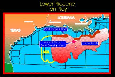
| Figure 9. |
Lower Pliocene Fan Play Map. |
| Figure 9a. |
Graph showing recoverable in place hydrocarbons (BOE) for the ten largest pools in the
lower Pliocene Fan Plays. Pools from fields in deep-water are outlined. |
| Figure 10. |
Lower upper Miocene Fan Play Map. |
| Figure 10a. |
Graph showing recoverable in place hydrocarbons (BOE) for the ten largest pools in the
lower upper Miocene Fan Plays. |
| Figure 11. |
Upper Middle Miocene Fan Play Map. |
| Figure 11a. |
Graph showing recoverable in place hydrocarbons (BOE) for the ten largest pools in the
upper middle Miocene Fan Plays. Pools from fields in deep-water are outlined. |
| |
|


