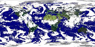
Global Cloud Cover during Hurricane Frances (WMS)
|
Water vapor is a small but significant constituent of the atmosphere, warming the planet due to the greenhouse effect and condensing to form clouds which both warm and cool the Earth in different circumstances. Warm, moisture-laden air moving out from the tropics brings clouds and rainfall to the temperate zones. This animation shows the cloud cover for the whole globe from September 1, 2004, through September 5, 2004, during the period of Hurricane Frances in the western Atlantic Ocean and Typhoon Songda in the western Pacific Ocean. The cloud cover in any region significantly affects the energy balance since sunlight reflected from the clouds is not available to heat the surface. The motion of clouds in this animation clearly indicates the speed and direction of winds around the globe.
|
|

|
|
Global cloud cover from the 0.25 degree resolution fvGCM atmospheric model for the period 9/1/2005 through 9/5/2005.
Duration: 20.0 seconds
Available formats:
640x320 (29.97 fps)
MPEG-1
5 MB
320x160
JPEG
24 KB
160x80
PNG
32 KB
80x40
PNG
8 KB
1000x721
Frames
How to play our movies
|
|
This product is available through our Web Map Service.
Click here to learn more.
|
|
|
|
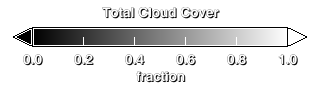
Legend for the total cloud cover.
Available formats:
320 x 90
PNG
761 B
|
|
|
Back to Top
|


