|
|
 |
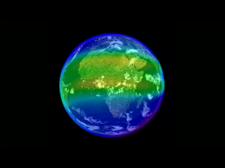
4D Ionosphere
|
NASA-funded researchers have unveiled a new '4D' live model of Earth's ionosphere at the Space Weather Workshop, Boulder, CO. Without leaving home, anyone can fly through the dynamic layer of ionized gases that encircles Earth at edge of space itself. All that’s required is a connection to the Internet. Airline flight controllers can use this tool to plan long-distance flights over the poles, saving money and time for flyers.
|
|
|
|
Introduction to the '4D Ionosphere' tool, Communication Alert and Prediction System.
For complete transcript, click here.
Duration: 2.8 minutes
Available formats:
640x360 (29.97 fps)
MPEG-1
42 MB
320x240 (29.97 fps)
MPEG-4
19 MB
640x480 (29.97 fps)
MPEG-4
38 MB
320x240
PNG
57 KB
160x80
PNG
26 KB
80x40
PNG
8 KB
640x360 (29.97 fps)
MPEG-4
30 MB
How to play our movies
|
|
|
|
Using the Google Earth interface, users can fly above, around and through these regions getting a true 4D view of the situation. The fourth dimension is time. This is a real-time system updated every 10 minutes. Bright red is high density electrons; that’s where radio communications are restricted to few or no frequencies. Blue is low density; no problem there.
Duration: 1.6 minutes
Available formats:
640x360 (29.97 fps)
MPEG-1
23 MB
640x480 (29.97 fps)
MPEG-4
20 MB
320x240 (29.97 fps)
MPEG-4
10 MB
320x180
PNG
175 KB
How to play our movies
|
|
|
|
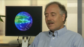
Interview clip with W. Kent Tobiska, Space Environment Technologies, Inc.
For complete transcript, click here.
Duration: 36.0 seconds
Available formats:
640x360 (29.97 fps)
MPEG-1
8 MB
640x480 (29.97 fps)
MPEG-4
8 MB
320x240 (29.97 fps)
MPEG-4
4 MB
320x180
PNG
164 KB
How to play our movies
|
|
|
Back to Top
|
|
|
|

