|
||
Where on Earth...? MISR Mystery Image Quiz #17
| ||||
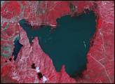
Here’s another chance to play geographical detective! This natural-color image from the Multi-angle Imaging SpectroRadiometer (MISR) represents an area of about 372 kilometers x 425 kilometers, and was captured by the instrument’s vertical-viewing (nadir) camera in December 2000. Only some of the following nine statements about the region shown are true. Use any reference materials you like to mark each statement true or false:
E-mail your answers, name (initials are acceptable if you prefer), and your hometown by the quiz deadline of Tuesday, February 17, 2004, to suggestions@mail-misr.jpl.nasa.gov Answers will be published on the MISR web site. The names and home towns of respondents who answer all questions correctly by the deadline will also be published in the order responses were received. The first three people on this list who are not affiliated with NASA, JPL, or MISR and who have not previously won a prize will be sent a print of the image. A new “Where on Earth...?” mystery appears as the MISR “latest featured image” approximately once every two months. New featured images are released on Wednesdays at noon Pacific time on the MISR home page. The image also appears on the Atmospheric Sciences Data Center home page, though usually with a several-hour delay. Image courtesy NASA/GSFC/LaRC/JPL, MISR Team. Text by Clare Averill (Raytheon / NASA JPL). Recommend this Image to a Friend Back to: Newsroom
Also see |
View Images Index
| |||
|
Subscribe to the Earth Observatory About the Earth Observatory Contact Us Privacy Policy and Important Notices Responsible NASA Official: Lorraine A. Remer Webmaster: Goran Halusa We're a part of the Science Mission Directorate |
 Click here to view full image