|
Ferry Lake,
Rodessa, and Punta Gorda Anhydrite Bed Correlation, Lower Cretaceous, Offshore Eastern
Gulf of Mexico
Petty, Andrew J.
Minerals Management Service,United States
Department of the Interior, New Orleans, LA
Abstract
The Lower Cretaceous Ferry Lake and Punta Gorda anhydrite has been used as marker beds
throughout the Gulf of Mexico, and divided into 9 individual anhydrite beds traceable from
southern Mississippi to southern Florida. The underlying Rodessa Formation has an equally
well developed anhydrite section in the offshore Eastern Gulf of Mexico and is divided
into 12 basin-wide anhydrite bed groupings. The anhydrites of Ferry Lake and Rodessa
Formations are traceable to the anhydrites of the Punta Gorda and Lehigh Acres Formations
of South Florida.
Anhydrite beds appear to thicken in the central part of the trend interfingering with
carbonates of the Lower Cretaceous shelf edge reef. Carbonates and anhydrites may be
deposited simultaneously with carbonate patchreefs developing on crests of paleo highs
with evaporates precipitating out of a hyper-saline solution on the flanks. Areas where
poor anhydrite bed development occurs may indicate areas of patch reefs and, therefore,
the best potential for hydrocarbon reservoirs.
Individual anhydrite beds have been correlated and color-coded on photocopies of
compensated neutron density logs to determine their geographic distribution. Prepared
cross sections show some beds to be area wide while others are more restricted. Isopach
maps show the configuration of the basin in which these beds were deposited with the
basin's long isopach axis parallel to the reef trend. Anhydrite deposition occurred with
evaporation of restricted highstand waters behind reefs that rimmed the shelf edge.
 |
Documents that have this symbol are in Adobe Acrobat's pdf format.
These files can be downloaded, read and printed using the free Acrobat Reader. |
The following figures correspond to the figures referenced in the Complete Text
above:
| Figure 1. |
Correlation chart of Lower Cretaceous rocks in Eastern Gulf of Mexico. Anhydrites of
Ferry Lake and Rodessa are equivalent to Punta Gorda and Able Member anhydrites, James
Limestone and Brown Dolomite of the Twelve Mile member are also stratigraphic equivalents.
Modified from AAPG, 1987; Lock et al, 1983; Wu et al, 1990; Pittman 1984; Winston, 1976;
Palacas et al, 1981; Applegate et al, 1981; Kimball, 1988; Richards, 1987. |
| Figure 2. |
Index and Structural Features of Eastern Gulf of Mexico. Area Names: Mobile (MO),
Pensacola (PE), Viosca Knoll (VK), Destin Dome (DD), Apalachicola (AP), Gainesville (GV),
Mississippi Canyon (MC), Desoto Canyon (DC), Florida Middle Ground (FM), Tarpon Springs
(TP), Atwater (AT), Lloyd (LL), The Elbow (EL), St. Petersburg (PB), Lund (LU), Henderson
(HE), Vernon Basin (VN), Charlotte Harbor (CH), Howell Hook (HH), Pulley Ridge (PR). |
| Figure 3. |
Electric Log from Bossier Parish, Louisiana, O.B. Mobley #15 Bolinger, T23N-R13W
(Pittman, 1985). This well shows individual beds of the Ferry Lake and Rodessa Formations.
M=Mooringsport, FL=Ferry Lake, R=Rodessa. |
| Figure 4. |
Cross Section showing 11 Ferry Lake and 3 Rodessa anhydrite beds in onshore
Mississippi correlating to 9 Ferry Lake and 12 Rodessa anhydrite beds in the offshore.
Ferry Lake and Rodessa anhydrite beds in the white become massive Punta Gorda and Lehigh
Acres Formation in south Florida. Line of section shown in Figure 1. |
| Figure 5. |
Compensated Neutron Formation Density Log (Destin Dome 56 OCSG-6482, well #2) showing
anhydrite beds in the Ferry Lake and Rodessa Formations offshore. *RO12, RO11, and RO10
are equivalent to R3, R2, and R1 of Pittman, 1985. RO=Rodessa Offshore, GR=Gamma Ray,
DPHI=Density Porosity |
| Figure 6a. |
Isopach map of Beds RO11 and RO12. Updip Limits are from Nunnally et al, 1954; Applin
et al, 1965; Raymond, 1995. C.I. 10 feet=3.048 meters on all Isopach Maps. |
| Figure 6b. |
Isopach map of Bed FL5. |
| Figure 6c. |
Isopach map of Bed FL6. |
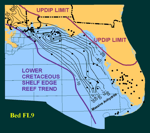
| Figure 6d. |
Isopach map of Bed FL9. |
| Figure 6e. |
Isopach map of Bed RO10 |
| Figure 6f. |
Isopach map of Bed RO9 |
| Figure 6g. |
Isopach map of Bed RO5. |
| Figure 6h. |
Isopach map of Bed RO4. |
| |
|


