|
 |
 |
| Home | News | Organization |
|
|
Station List Observations Recent Historical Obs Search Ship Obs Report NOAA Obs APEX DART MMS ADCP TAO DODS HF Radar OSMC Dial-A-Buoy RSS Feeds Email Access Station Status NDBC Maintenance NDBC Platforms Partner Platforms Program Info About NDBC Met/Ocean Moored Buoy C-MAN TAO DART VOS CSP IOOS DAC Publications Hurricane Data Plots Mariners Weather Log Observing Handbook No. 1 Science Education FAQ Contact Us Links |
Station CASM1 - 8418150 - Portland, MEStation CASM1 is located at 43.657 N 70.247 W (43°39'24" N 70°14'48" W) 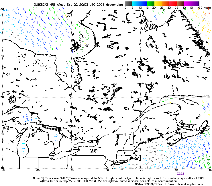
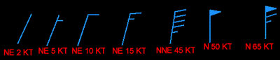
The source of QuikSCAT wind information displayed here is NOAA's National Environmental Satellite and Data Information Service (NESDIS) Office of Research and Applications. The user assumes the entire risk related to use of this data. NWS/NDBC is providing this data "as is," and the standard NWS disclaimer applies. Satellites can estimate the winds over the surface of the ocean to a high degree of accuracy. Because the satellite used crosses the poles as it orbits the earth, it passes over the same location only twice a day. Therefore, no more than two wind estimates each day are possible for any specific location. To find the time of each image, look at the bottom of the map, and you will see one or more times in GMT (or UTC). These times are when the satellite crossed the lowest latitude on your map for that pass. All winds shown on the map are within two hours of that time. Note that there are breaks between the passes, so the coverage is not continuous in either space or time. Our web site tries to pick the most recent map of surface winds for your area. For an explanation of wind barbs, see the chart below:
DO NOT USE BLACK WIND BARBS. These are possibly contaminated by rainfall and could be incorrect.
QuikSCAT images are produced by two NESDIS offices.
Clickable maps for selecting wind maps of other areas are at NESDIS Office of Research and Applications. Another method for selecting a wind map (with the Global products preselected) is at NESDIS CoastWatch. For a description of how ocean winds are measured by satellite, see: http://winds.jpl.nasa.gov/aboutScat/index.cfm.
|