Advanced Hydrologic Prediction Service: Raleigh: Tar River at Tarboro
Skip Navigation Linkweather.gov 
NOAA logo - Click to go to the NOAA homepage National Weather Service   NWS logo - Click to go to the NWS homepage
Advanced Hydrologic Prediction Service

Tar River at Tarboro, NC (TARN7)

Data Type


Inundation Levels
NAVD88 Stage

53.043.7
52.042.7
51.041.7
50.040.7
49.039.7
48.038.7
47.037.7
46.036.7
45.035.7
44.034.7
43.033.7
42.032.7

Major Flooding Begins

41.031.7
40.030.7
39.029.7
38.028.7
37.027.7
36.026.7
35.025.7
34.024.7

Moderate Flooding Begins

33.023.7
32.022.7
31.021.7
30.020.7
29.019.7

Flooding Begins

28.018.7


  Map Zoom In Map Zoom In Map Zoom In Map Zoom In Map Zoom In Map Zoom In Map Zoom In Map Zoom In Map Zoom In
Weather Forecast Office Raleigh, NC Southeast River Forecast Center

To see all current watches and warnings, click here.
Scale Map

Hydrograph River at a Glance Download Inundation
Mapping
Weekly Chance of
Exceeding Levels
Chance of Exceeding Levels
During Entire Period
Image Type:
Current Stage: 5.32 ft at 20:15 UTC 01/15
Map Zoom In Map Zoom In Map Zoom In Map Zoom In Map Zoom In Map Zoom In Map Zoom In Map Zoom In Map Zoom In
Please wait while the page loads.
  

Selected Inundation
NAVD88: N/A ft
Stage: N/A ft

Print / Save Image
About Inundation
Download Dataset(s)
FAQ
User Guide
Inundation Sites
Mouse Location*
Latitude: N/A N
Longitude: N/A W
* All mouse location values are estimates only.

Zoom InClick on the image to zoom in

Graphical representation of flood inundation for NWS flood categories are based on steady state hydraulic modeling of water surface elevations for incremented discharges. Map shows approximate inundation areas for given water surface elevations and should not be used for navigation or permitting or other legal purposes, but strictly as a planning reference tool.

North Arrow Flood Categories (in feet)
Major Flood Stage:32
Moderate Flood Stage:24
Flood Stage:19
Action Stage:19
Below Flood Stage:

USGS Gauge Location USGS Gauge Location

Extent of Inundation Study Boundaries Extent of Inundation Study Boundaries

Historical Crests
(1) 41.51 ft on 09/19/1999
(2) 34.00 ft on 07/27/1919
(3) 33.50 ft on 10/04/1924
(4) 31.77 ft on 08/20/1940
(5) 30.20 ft on 09/24/1928
Show More Historical Crests

Return to Area Map

Impacts & Photos Collapse
41.5 This is the Flood of Record. Hurricane Floyd, Sept. 19, 1999
38.6 This is the highest elevation of the Princeville Dike
37.0 Failure may be expected at the Princeville Dike. There is considerable street flooding in Tarboro
34.6 Water has reached the lowest elevation of the Princeville Dike
33.6 This is the elevation of the railroad atop the Princeville dike. The gate has to be closed to prevent water from flowing into the town of Princeville
32.0 Major Flooding begins
27.0 a portion of US64 Business in Princeville begins to flood
26.6 this is the stage reached during Hurricane Fran on Sept. 15, 1996
24.0 Moderate Flooding begins in Tarboro
23.0 There is minor street flooding in Tarboro
20.0 Lowland flooding occurs in Tarboro
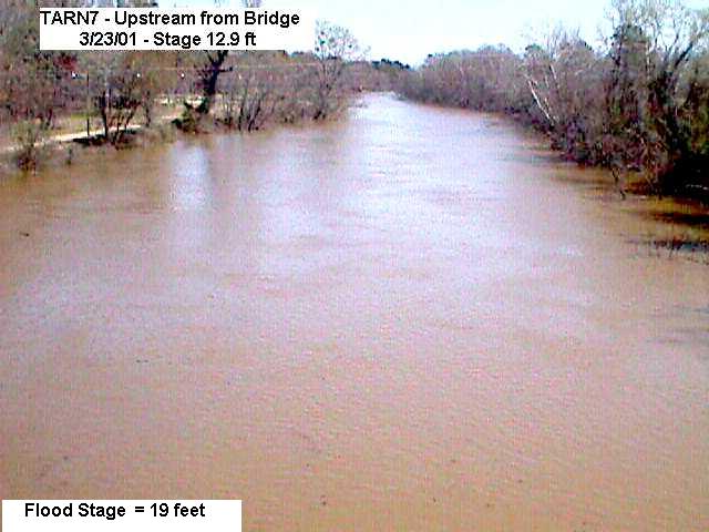
19.0 This is the flood stage. Minor flooding begins. A park and dirt road near the US64 bridge floods
18.0 Bankfull
Photos
(1) Gauge Site

Other Data Sources:
U.S. Geological Survey (USGS) Data and Site Info for Tarboro

Additional Information Collapse

Gage Photos
Gage Photo
Inundation Map
Inundation Mapping


Resources Collapse
Hydrologic Resources
Additional Resources
   

Collaborative Agencies Collapse
The National Weather Service prepares its forecasts and other services in collaboration with agencies like the US Geological Survey, US Bureau of Reclamation, US Army Corps of Engineers, Natural Resource Conservation Service, National Park Service, ALERT Users Group, Bureau of Indian Affairs, and many state and local emergency managers across the country. For details, please click here.

NWS Information
National Weather Service
Raleigh Weather Forecast Office
1005 Capability Drive, Suite 300
Raleigh, NC 27606
(919) 515-8209
Ask Questions/Webmaster
Page last modified: 12-Jun-2008 4:20 PM
Disclaimer
Credits
Glossary
Privacy Policy
About Us
Career Opportunities