
Images & Animations
-
Credit
NASA/Goddard Space Flight Center Scientific Visualization Studio
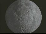
Lunar Rotation and Flyby from Clementine Data
Clementine was a joint project between the Strategic Defense Initiative Organization and NASA. The objective of the mission was to test sensors and spacecraft components under extended exposure to the space environment and to make scientific observations of the Moon and the near-Earth asteroid 1620 Geographos. Clementine was launched on 25 January 1994 at 16:34 UTC (12:34 PM EDT) from Vandenberg AFB aboard a Titan IIG rocket. After two Earth flybys, lunar insertion was achieved on February 21. Lunar mapping took place over approximately two months, in two parts. The first part consisted of a 5 hour elliptical polar orbit with a perilune of about 400 km at 28 degrees S latitude. After one month of mapping the orbit was rotated to a perilune of 29 degrees N latitude, where it remained for one more month. This allowed global imaging as well as altimetry coverage from 60 degrees S to 60 degrees N.
Lunar rotation and surface flyby using LIDAR data from Clementine
Metadata
-
Sensor
-
Animation ID
80 -
Video ID
SVS1995-0002 -
Start Timecode
0:05:12:02 -
End Timecode
0:08:09:06 -
Animator
Cindy Starr -
Studio
SVS -
Visualization Date
1995/06/09 -
Scientist
David Smith (NASA/GSFC), Maria Zuber (Massachusetts Institute of Technology), Frank Lemoine (NASA/GSFC), Gregory Neumann (Johns Hopkins University) -
Citation
Maria T. Zuber, David E. Smith, Frank G. Lemoine, Gregory A. Neumann, The Shape and Internal Structure of the Moon from the Clementine Mission, Science, 16 December 1994, pp. 1839-1843. -
Keywords
Moon, Lunar -
DLESE Subject
Space science -
Data Date
1994/02/26-1994/05/05 -
Story URL
http://nssdc.gsfc.nasa.gov/planetary/clementine.html -
Animation Type
Regular