| Oregon Covered Bridges |
|
|
 |
| Overview |
|
|
|
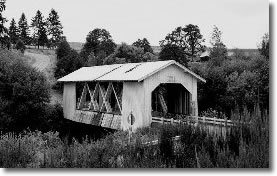
Jordan Covered Bridge (1937)
|
Oregon has the largest collection of covered bridges in the western part of the United States, with over 50 extant covered spans. Because of the easy availability of forest resources in Oregon, most of the early bridges in the state were timber structures. These timber bridges were often covered to protect them from the weather. Now, the remaining examples of this obsolete bridge construction technology, generally located in pastoral rural settings, provide one of the most significant tourist attractions in the state. The bridge shown above is the Jordan Covered Bridge (1937), now lost.
NEW!! ODOT´s Bridge Section has recently completed a survey of Oregon´s Covered Bridges, and has prepared a new website which includes information, photos, and maps to each of the covered bridges in the state. The file is assembled in PDF format, and requires Acrobat Reader to view. Additionally, the file size is large, and will take a few minutes to load using a dial-up modem connection. The online PDF version of the new Covered Bridges information and maps can be accessed here. If you have difficulty downloading the file, a CD version of the information is available free of charge from the ODOT Bridge Section. You can order the Covered Bridges CD here.
In 1990, the Oregon Department of Transportation worked with the Oregon Legislature to create the first comprehensive covered bridge preservation program in the nation. For information on other historic bridges in Oregon contact James Norman, Environmental Planning Manager.
(All photo's provided by James Norman, ODOT.)
|
| Weddle Bridge |
|
|
Thomas Creek (Weddle/Devaney) Bridge
Cascade Forest Resource Center, Sweet Home vicinity
Linn County, built 1937, relocated 1987
This bridge goes by two names: Linn County signed the structure "Weddle" Bridge after a nearby farmer, but locals preferred Devaney for another area resident. This bridge was removed from its original location on Kelly County Road, near Crabtree and placed in storage in 1987. In 1990 the 120-foot long housed Howe truss bridge was rebuilt at the Cascade Forest Resource Center, in Sweet Home. Sometime before it was moved to its current location the bridge had been closed to vehicular traffic, as a new replacement concrete span was built a quarter-mile away from its original location. The bridge is very similar in design to the other Thomas Creek covered bridges in Linn County.
|
| Larwood Bridge |
|
|
Crabtree Creek (Larwood) Bridge
Fish Hatchery Drive County Road, Crabtree vicinity
Linn County, 1939
Located at the confluence of the Roaring River and Crabtree Creek, the Larwood Bridge carries the historical name of the community. William T. Larwood opened the post office at a site in the vicinity of the bridge in 1893. The Larwood Bridge is one of three covered bridges across the Crabtree Creek in Linn County. The 105-foot housed Howe truss exhibits the common Linn County design of exposed truss side openings. The bridge is open to vehicular traffic and is adjacent to the Larwood Wayside Park.
|
| Myrtle Creek Bridge |
|
|
South Myrtle Creek (Neal Lane) Bridge
Neal Lane County Road, Myrtle Creek vicinity
Douglas County, 1939
One of the shortest covered bridges in Oregon at 42 feet, the Neal Lane Bridge is the only covered bridge with a kingpost truss in the state. The plank flooring, arched portals, narrow window openings, and rural setting add to the appeal of this bridge. The Neal Lane Bridge, built for only $1,000, was constructed by Douglas County in 1939. Floyd C. Frear was the county engineer, with Homer Gallop, the bridge foreman.
|
| Calapooia Bridge |
|
|
Calapooia River (Crawfordsville) Bridge
Halsey-Sweet Home Highway, Crawfordsville vicinity
Linn County, 1932
Orginally built by the county in 1932, the 105-foot Crawfordsville Bridge became part of a state highway route and remained in state ownership until bypassed in 1963. The bridge is closed to vehicular traffic, but serves as an historical exhibit-in-place in a Linn County Park. The community of Crawfordsville was named for Philemon Crawford, who settled in the area in the 1870´s. This Linn County structure displays eye-level ribbon openings, instead of the large exposed open truss plan of other bridges common to Linn County. The orginal semi-circular portal arches were modified to allow larger loads through the bridge.
|
| Gallon House Bridge |
|
|
Abiqua Creek (Gallon House) Bridge
Gallon House County Road, Silverton vicinity
Marion County, 1917
The Gallon House Bridge is the last remaining covered bridge in Marion County and one of the oldest covered bridges in Oregon. This structure is an 84-foot housed Howe truss with a timber roadway deck. Gallon House has rectangular portals, narrow ribbon openings at the eaves, and board-and-batten siding. The bridge is open to traffic. Marion County completed major repairs to the bridge in 1985. According to local tradition, the bridge owes its name to an unauthorized liquor dispensary which operated at the north approach prior to prohibition. During that time, Silverton to the south was a dry town, while Mount Angel to the north was not.
|
| Grave Creek Bridge |
|
|
Grave Creek Bridge
Sunny Valley-Placer County Road, Sunny Valley Vicinity
Josephine County, 1920
Because of its proximity to Interstate 5, the Grave Creek Bridge is Oregon´s most viewed covered bridge. Orginally built on the Pacific Highway (U.S. 99) in 1920, the structure was built by the State Highway Department and is a standardized state covered bridge. The housed Howe truss is 105-feet long. The orginal semi-elliptical portal arches have been reshaped to provide increased height clearance. Architectural features include false end heads. The Grave Creek Bridge is the only remaining covered bridge in Josephine County.
|
| Jordan Bridge |
|
|
Thomas Creek (Jordon) Bridge
Stayton Park, Stayton Vicinity
Linn County, Built 1937, Relocated 1988
A prominent local landmark and an attractive example of covered bridges, the Jordan Bridge is a 90-foot housed Howe truss. It was originally located on Jordan County Road near Lyons, but was later moved to a city park in Stayton. The bridge takes its name from the community of Jordan, named for the Jordan Valley in Israel. The Jordan Bridge is one of Linn County´s seven distinctive covered bridges with large side openings. The portal arches were originally rounded or segmental, but have been altered to a truncated rectangular shape, expanding clearance for large loads. The bridge was determined eligible for the National Register in February 1984.
|
| Office Bridge |
|
|
North Fork of the Middle Fork of the Willamette River (Office) Bridge
Private Road, Westfir Vicinity
Lane County, 1944
The most massive and longest of Oregon's covered bridges, this 180-foot housed Howe truss was constructed by the Westfir Lumber Company using triple timber beams to afford the strength nessary to carry heavy logging trucks. The bridge connects the lumber mill with the office (hence the common name of the bridge). The structure is one of only two covered bridges in Oregon built with triple truss members. A distinction of the bridge is the covered walkway on the side of the bridge, separate from the roadway. Westfir was established in 1923 as a company town by the Western Lumber Company. The privately owned bridge is closed to public traffic.
|
| Remote Bridge |
|
|
Sandy Creek (Remote) Bridge
Sandy Creek County Road, Remote Vicinity
Coos County, 1921
The 60-foot Remote Bridge is the only remaining covered span in Coos County. Bypassed in 1949, the Remote Bridge was formerly in state ownership on State Route 42. The truss consists of two crossed Howe truss members on each chord, a rarity in short covered trusses. The design of the bridge with large side openings is similar to those found in Linn County. Until the mid-1980's, the bridge was in poor condition, but has now been restored by volunteers. In September 1984, the bridge was dedicated as a Coos County park and serves pedestrian uses.
|
| Short Bridge |
|
|
South Fork Santiam River (Short) Bridge
High Deck County Road, Cascadia Vicinity
Linn County, 1945
Orginally named for the nearby topographic feature, Whiskey Butte, the Whiskey Butte Bridge was later renamed for long-term area resident, Gordon Short. The housed Howe truss is 105-feet in length and has the distinctive open feeling of most of Linn County's covered bridges. The open truss provides increased height visibility to the traveler and keeps wind resistance to a minimum. Familiar desing features also include segmental portal arches, exposed gable end beams, and white board-and-batten siding.
|
| Drift Creek Bridge |
|
|
Drift Creek Bridge
Drift Creek County Road, Lincoln City Vicinity
Lincoln County, 1914 (est.)

Though there is some controversy regarding the actual construction date of the Drift Creek Bridge, this structure has traditionally been noted as the oldest covered span in Oregon. It also had the distinction of being the covered bridge closest to the Oregon Coast, only 1-1/2 miles from the Pacific Ocean. Built by Lincoln County, the 66-foot housed Howe truss structure cost about $1,800 in 1914. The bridge has long been closed to vehicular traffic but served pedestrian traffic up until quite recently when the approaches were removed. The Drift Creek bridge housing included flared board-and-batten siding, arched portals, ribbon daylighting and wooden flooring. Lincoln County maintained the bridge as a historical exhibit-in-place since 1965. Unfortunately, this venerable old bridge was dismantled and removed from its original location in the fall of 1997, due to severe structural problems. The bridge is currently being reconstructed on private property near the small community of Otis.
|
| Hannah Bridge |
|
|
Thomas Creek (Hannah) Bridge
Camp Morrison Drive, County Road 830, Scio Vicinity
Linn County, 1936
The Hannah Bridge was originally one of five covered spans on Thomas Creek in Linn County, before the Jordan Bridge and Weddle Bridge were relocated. The 105-foot housed Howe truss is exposed through the large side openings on the bridge. Very attractive in appearance, the characteristic Linn County covered bridge design includes segmental portal arches, exposed beams at the gable ends, and white board-and-batten cladding. Thomas Creek was named for Frederick Thomas, who obtained a donation land claim on the banks of the stream in 1846.
|
|
| |
|
|