NCDC | Climate | Products | Events | Search | Help
Hurricane Bonnie edged into North Carolina's southern coastline near Wilmington on August 26, 1998. Bonnie was the first major hurricane (Category 3) of the 1998 season, and the winds and flooding rains damaged buildings and cut off power to nearly a half-million people. The storm, which was nearly 400 miles wide, stalled near Wilmington for an hour after its eye crossed land at Cape Fear at 5 PM EDT on August 26th. Due to the slow movement of Bonnie, rainfall totals were rather high in parts of eastern North Carolina and extreme southeastern Virginia. Overall damages are estimated in the $1.0 billion dollar range. Insured losses were approximately $360 million, but these losses do not include flooding and agricultural damages, which were quite extensive. Three deaths were attributed to the storm.
Peak wind gusts recorded during the hurricane included:
Frying Pan Shoals Light Tower (off NC coast) - 104 mph
Wilmington, NC - 74 mph
Myrtle Beach, SC - 77 mph
Hurricane Bonnie approaching Carolina coast (MPEG Movie ~1.2 MB)
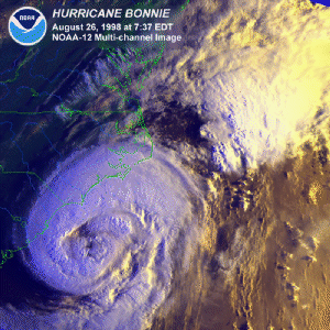
Hurricane Bonnie near Carolina coast - Colorized IR - (August 26)
Hurricane Bonnie - Colorized IR (August 25)
Hurricane Bonnie and Tropical Storm Danielle - 8km (August 25)
Hurricane Bonnie-Water Vapor Image (August 26)
Nexrad Radar Image of Bonnie Just Inland in North Carolina (August 27, 13 GMT)
Nexrad Radar Image of Bonnie In Coastal North Carolina (August 27, 15 GMT)
Nexrad Storm Total Precipitation (August 27)--note the 8.00+ inch amounts in southeastern North Carolina
Hurricane Bonnie Preliminary Precipitation Reports--rainfall in affected areas of North Carolina and Virginia for the 4-day period ending at 12Z on Aug 29, 1998 - amounts listed for totals of at least 2.00 inches. List includes National Weather Service cooperative stations as well as various river forecasting network gauges, as provided by the Climate Prediction Center.
DAY = Number of days of data for Aug 26-29, 1998 period
ID = National Weather Service Station ID
STATION = Station name
COUNTY = County for the station
ST = State
ELEV = Elevation in feet if exact value is known
LAT/LON = Latitude and Longitude in degrees and hundredths
RAIN = Total reported rainfall (inches) for Aug 26-29 period, ending at
       12Z on the 29th


DAY  ID    STATION           COUNTY         ST  ELEV  LAT     LON     RAIN

 4  NCA    JACKSONVILLE      ONSLOW         NC    24  34.72N  77.43W  11.34
 4  NKT    CHERRY POINT      CRAVEN         NC        34.90N  76.88W  11.03
 4  ILM    WILMINGTON        NEW HANOVER    NC    31  34.28N  77.91W   9.45
 4  GREN7  GREENVILLE        PITT           NC    32  35.63N  77.40W   8.20
 2  SHAN7  SHALLOTTE         BRUNSWICK      NC    20  33.92N  78.38W   6.50
 4  LNGN7  LONGWOOD          BRUNSWICK      NC    40  34.02N  78.55W   6.42
 4  WILN7  WILSON            WILSON         NC   110  35.70N  77.95W   5.56
 4  WLLN7  WILLIAMSTON       MARTIN         NC    20  35.85N  77.03W   5.55
 2  ELZN7  ELIZABETHTOWN     BLADEN         NC    60  34.63N  78.58W   5.49
 3  CBAN7  COLUMBIA          TYRRELL        NC    10  35.73N  76.13W   5.38
 4  NGU    NORFOLK           PRINCESS ANNE  VA        36.83N  76.33W   5.18
 4  CLIN7  CLINTON           SAMPSON        NC   158  35.02N  78.28W   4.79
 4  EDNN7  EDENTON           CHOWAN         NC    20  36.18N  76.78W   4.35
 4  RWI    ROCKY MOUNT       NASH           NC        35.85N  77.89W   4.28
 4  GOLN7  GOLDSBORO         WAYNE          NC   109  35.45N  77.97W   4.08
 2  RKMN7  ROCKY MOUNT       NASH           NC   130  35.90N  77.88W   3.80
 4  EFDN7  ENFIELD           HALIFAX        NC   110  36.18N  77.68W   3.66
 2  WHVN7  WHITESVILLE       COLUMBUS       NC    50  34.27N  78.70W   3.50
 4  SMIN7  SMITHFIELD        JOHNSTON       NC   150  35.52N  78.35W   3.02
 4  GSB    GOLDSBORO         WAYNE          NC   109  35.33N  77.97W   2.91
 4  STPN7  SAINT PAULS       BLADEN         NC    30  34.83N  78.80W   2.88
 4  ERWN7  ERWIN             HARNETT        NC   200  35.32N  78.68W   2.83
 3  CYNN7  CLAYTON           JOHNSTON       NC   330  35.65N  78.50W   2.76
 4  TARN7  TARBORO           EDGECOMBE      NC    35  35.88N  77.53W   2.61
 4  LFI    HAMPTON           HAMPTON (CITY) VA    10  37.07N  76.35W   2.52
 3  PHF    NEWPORT NEWS      NEWPORT NEWS   VA        37.13N  76.49W   2.49
 4  LBRN7  LUMBERTON         ROBESON        NC   112  34.62N  78.98W   2.45
 4  FAY    FAYETTEVILLE      CUMBERLAND     NC        34.99N  78.88W   2.40
 3  FAYN7  FAYETTEVILLE      CUMBERLAND     NC    96  35.07N  78.87W   2.17
 3  ZEBN7  ZEBULON           WAKE           NC   260  35.80N  78.37W   2.10
National Hurricane Center
Storm '98 Hurricane Central
Climatic Extremes and Weather Events
Hurricanes--Climatology and Reports
 Top of Page Top of Page
http://lwf.ncdc.noaa.gov/oa/reports/bonnie/bonnie.html
Downloaded Tuesday, 16-Sep-2008 05:17:24 EDT
Last Updated Tuesday, 12-Sep-2006 15:42:42 EDT by Neal.Lott@noaa.gov, Tom.Ross@noaa.gov, Axel.Graumann@noaa.gov, Mark.Lackey@noaa.gov
Please see the NCDC Contact Page if you have questions or comments.
|
