- NASA Home
- | Missions
- | Hurricanes
- | Archives
- | 2008
Feature
For Hurricanes, Storms, Raindrop Size Makes All the Difference
06.09.08
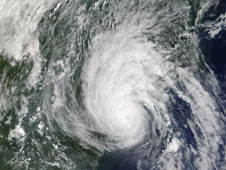
 Tropical Storm Gaston moved ashore over the coast of McClellanville, South Carolina on August 29, 2005 as captured by the MODIS instrument aboard NASA's Terra satellite. At the time this image was taken, Gaston poured large amounts of small and mid-sized raindrops across several states, including the city of Richmond, Va. Credit: NASA
When Tropical Storm Gaston hit Richmond, Va., in August 2004, its notable abundance of small and mid-sized raindrops created torrential rains that led to unexpected flash flooding throughout the city and its suburbs. New research from NASA has concluded that tropical cyclones like Gaston produce rain differently than another class of storms called "extra-tropical" cyclones. According to the study, making a proper distinction between these systems by looking at both raindrop size and abundance may be a key to assisting weather forecasters in estimating rainfall intensity. By doing so, forecasters can reduce the surprise factor of flash flooding and the unfortunate loss of property and life.
 Ali Tokay, a research scientist from the Joint Center for Earth Systems Technology (JCET) at the University of Maryland Baltimore County, Baltimore, and NASA's Goddard Space Flight Center, Greenbelt, Md., compared the rain measurements collected in tropical storms and hurricanes during the past three Atlantic hurricane seasons with measurements after these storms transitioned to being extra-tropical. Tokay’s study appeared in the May issue of the American Meteorological Society’s Monthly Weather Review.
When a tropical cyclone -- the generic name for tropical depressions, tropical storms and hurricanes -- merges with a mid-latitude frontal storm system, measurable changes to the raindrop size and abundance occur as the system transitions to become extra-tropical. Extra-tropical cyclones also form outside the tropics without being part of a tropical system, and tend to form over land rather than over the open ocean. This category of storm can produce anything from a cloudy sky to a thunderstorm as it develops between weather fronts, the boundaries separating air masses of different densities.
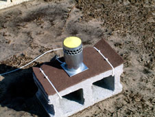
 Disdrometers like this one measure rainfall rates and size distribution. Credit: NASA
Tokay looked at raindrop size, rain intensity, and the area in which rain falls in both tropical cyclones and extra-tropical cyclones using ground-based rain-measuring instruments called disdrometers. These instruments measure the range of raindrop sizes in a storm and the intensity of the rainfall. The disdrometer is an important part of the ground-based rain measuring instruments that are used to validate rainfall seen from satellites including the Tropical Rainfall Measuring Mission (TRMM), a joint mission with NASA and the Japanese Space Agency. He concluded that tropical cyclones that form over water tend to rain harder and have a greater amount of smaller drops before they transition to being extra-tropical with raindrops of larger size and mass.
Disdrometers like this one measure rainfall rates and size distribution. Credit: NASA
Tokay looked at raindrop size, rain intensity, and the area in which rain falls in both tropical cyclones and extra-tropical cyclones using ground-based rain-measuring instruments called disdrometers. These instruments measure the range of raindrop sizes in a storm and the intensity of the rainfall. The disdrometer is an important part of the ground-based rain measuring instruments that are used to validate rainfall seen from satellites including the Tropical Rainfall Measuring Mission (TRMM), a joint mission with NASA and the Japanese Space Agency. He concluded that tropical cyclones that form over water tend to rain harder and have a greater amount of smaller drops before they transition to being extra-tropical with raindrops of larger size and mass.“Torrents of rainfall from tropical storms are not surprising since the systems are large and move slowly. It is also true that slow moving frontal systems associated with an extra-tropical cyclone can result in abundant rainfall at a site,” said Tokay. “What is less known is that the distribution of raindrops within a volume of air between the two systems differs substantially even though weather radar may measure the same returned power which is known as reflectivity.” This is why disdrometer measurements of raindrop size are needed.
“Both rain intensity and reflectivity are integral products of raindrop size distribution, but they are mathematically related to different powers of the drop size,” said Tokay. Weather radars cannot measure the range of raindrop sizes. As a result, rainfall estimates from weather radars must employ the use of equations that make assumptions about raindrop size. These assumptions can result in underestimation of rain intensity, and the possibility of deadly flooding.
 Hurricane Cindy (2005) was observed after it became an extratropical cyclone indicated by larger raindrops that are decreasing in abundance (lots of blue and green) of raindrops as the hours pass when compared to smaller raindrops in greater abundance (lots of red) during Hurricane Charley (2004). b>Click image to enlarge. Credit: NASA/Ali Tokay
In the study, Tokay uses disdrometer data from various sites around the U.S. and abroad. Most of the data were collected at NASA's Wallops Flight Facility, Wallops Island, Va., where Paul Bashor of Computer Sciences Corporation, Wallops Island, Va. maintains several types of disdrometers. The data from two tropical storms were collected at Orlando, Fla., and Lafayette, La. through collaborative efforts with Takis Kasparis at the University of Central Florida’s Orlando campus, and Emad Habib of the University of Louisiana at Lafayette.
Hurricane Cindy (2005) was observed after it became an extratropical cyclone indicated by larger raindrops that are decreasing in abundance (lots of blue and green) of raindrops as the hours pass when compared to smaller raindrops in greater abundance (lots of red) during Hurricane Charley (2004). b>Click image to enlarge. Credit: NASA/Ali Tokay
In the study, Tokay uses disdrometer data from various sites around the U.S. and abroad. Most of the data were collected at NASA's Wallops Flight Facility, Wallops Island, Va., where Paul Bashor of Computer Sciences Corporation, Wallops Island, Va. maintains several types of disdrometers. The data from two tropical storms were collected at Orlando, Fla., and Lafayette, La. through collaborative efforts with Takis Kasparis at the University of Central Florida’s Orlando campus, and Emad Habib of the University of Louisiana at Lafayette.Related Link:
> Tropical Rainfall Measuring Mission Web site
Goddard Space Flight Center