
- NASA Home
- | Missions
- | Hurricanes
- | Archives
- | 2008
Featured Images
Hurricane Season 2008: Tropical Storm Hanna (Atlantic Ocean)
Tropical Storm Hanna in Eastern Canada, Now Extra-Tropical
Tropical Storm Hanna was centered over New England during the early morning of Sunday, Sept. 7, and reached eastern Canada by mid-day.
At 5:00 a.m., Hanna's center was close to a frontal boundary. Meanwhile, the convection (rapidly rising air that creates thunderstorms) near her center was weakening, an Hanna was no longer considered to be a tropical cyclone by the National Hurricane Center at 5:00 a.m. EDT on Sept. 7.
At that time, her maximum sustained winds were still near 50 mph. She was located about 60 miles north of Chatham, Massachusetts or 350 miles west-southwest of Halifax, Nova Scotia. That's near 42.6 north latitude and 70.0 west longitude. She's was moving northeast near 36 mph, and by 11:00 a.m. EDT, her center of circulation was over Canada. She's now considered "extra-tropical."

> Larger image
Credit: NASA/NOAA GOES Project This visible image of Hanna was created on Sept. 7 at 14:32 UTC (10:32 a.m. EDT) from the Geostationary Operational Environmental Satellite (GOES-12), and Hanna's clouds are seen in the top right corner of the image, over eastern Canada.
GOES-12 is operated by the National Oceanic and Atmospheric Administration. It was created by NASA's GOES Project, located at NASA's Goddard Space Flight Center, Greenbelt, Md.
Some Rainfall Totals
New York City's Central Park reported 3.26 inches of rain from Hanna as she passed by on Saturday. JFK Airport received 2.51 inches, Upton, NY had 2.90 inches, and Boston, Massachusetts received 1.86 inches of rain.
Text credit: Rob Gutro/Goddard Space Flight Center
Sept. 6, 2008, second update
Hanna Making Her Way Up the U.S. East Coast, Hitting Washington DC
The Nation's Capital hasn't been under a tropical storm warning since 2003, when Hurricane Isabel roared up the Chesapeake Bay. Now, as Hanna plows up the U.S. East Coast on Saturday, Sept. 6, Washington, D.C is again under a tropical storm warning. That means tropical storm conditions are occurring and the rains were coming down at 9:00 a.m. EDT.
The GOES Satellite Captures Hanna's Track Up the U.S. East Coast

> Click to view movie
As Hanna was raining on Washington, D.C. the Geostationary Operational Environmental Satellite (GOES-12) has been watching her. This movie was created using satellite imagery from Sept. 4-6 from GOES-12. It shows Tropical Storm Hanna located over the Bahamas on Sept. 4, making landfall in the Carolinas and near Washington, D.C. on Sept. 6 on her way to New England.
GOES-12 is operated by the National Oceanic and Atmospheric Administration. It was created by NASA's GOES Project, located at NASA's Goddard Space Flight Center, Greenbelt, Md. Image and movie credit: NASA/NOAA GOES Project
Live National Weather Service Radar From Washington, D.C.: > NWS radar
Where is Hanna on Saturday, Sept. 6?
At 8:00 a.m. EDT on Sept. 6, Hanna's center was moving speedily through eastern North Carolina. She was about 40 miles east-southeast of Raleigh, North Carolina, near latitude 35.6 north and longitude 78.1 west. Hanna is moving toward the north-northeast near 22 mph and should turn to the northeast and speed up later today or Sunday, Sept. 7.
Hanna's maximum sustained winds have decreased to near 50 mph with higher gusts, and is expected to maintain strength today. Goldsboro, NC reported a wind gust of 52 mph on Saturday morning. The estimated minimum central pressure based on surface observations is 985 millibars.
Hanna's center will skirt across eastern North Carolina this morning, and then along the Mid-Atlantic coast today and tonight before arriving in New England and southeastern Canada on Sunday.
Forecast Storm Surges, Rainfall, Isolated Tornadoes
The National Hurricane Center forecast notes that the coastal storm surge flooding along the Atlantic coasts of South Carolina and North Carolina should gradually subside today. Today, Storm surge flooding of 1 to 3 feet above normal tide levels is expected in the Albemarle and Pamlico sounds and in Chesapeake Bay. Those will subside tonight after Hanna quickly passes to the northeast.
Hanna's rainfall expected from central North Carolina northeastward through eastern portions of the Mid-Atlantic states, southern New York and into southern New England will range from 4 to 6 inches with isolated maximum amounts of 10 inches possible. These rainfall amounts could produce flash flooding across these regions.
Another threat is isolated tornadoes. Tornadoes are possible today over eastern North Carolina, eastern Virginia, and southern Maryland.
For up to the minute forecasts, visit: > National Hurricane Center
Text credit: Rob Gutro/Goddard Space Flight Center
Sept. 6, 2008, first update
Hanna Falls Short of Hurricane Status
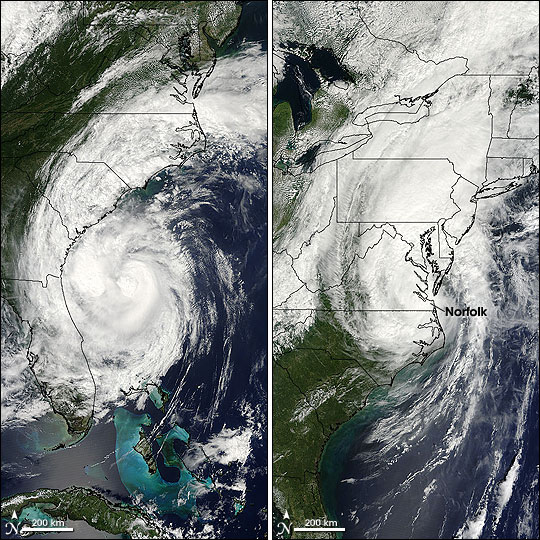
 Hanna on September 5 (left) and 6 (right).
Credit: Jeff Schmaltz, MODIS Rapid Response Team
> Larger image Tropical Storm Hanna did not reach hurricane strength before making landfall near the South Carolina–North Carolina state line in the pre-dawn hours of September 6, 2008, instead hovering just on the brink of minimal Category 1 hurricane status. When the National Hurricane Center issued their 2:00 a.m. Eastern Daylight Time advisory on September 6, Hanna was just about to make landfall, with sustained winds of 110 kilometers per hour (70 miles per hour.)
This pair of images from the Moderate Resolution Imaging Spectroradiometer (MODIS) sensors on NASA’s Aqua (September 5, left) and Terra satellites (September 6, right) shows how quickly the storm was moving in its final approach to the U.S. East Coast. On Friday afternoon (September 5), the eye of the storm was about 250 kilometers east of the Florida–Georgia state line. In just under a day, the weakening center of the storm was located west-northwest of Norfolk, Virginia, and Hampton Roads Harbor—more than 730 kilometers (more than 455 miles) north-northeast.
Text credit: Rebecca Lindsey
Sept. 5, 2008, third update
NASA Satellite Sees Hanna's Clouds and Rains From Va. to Fla.
 Credit: NASA/JPL
> Larger image Hanna's rains have a long reach. At 4:10 p.m. EDT Friday, Sept. 5, she her rains stretched as far south as Daytona Beach, Fla., north to Richmond, Va.!
A Satellite View of Cloud Temperatures and Rain
This infrared image of Hanna was created by data from the Atmospheric Infrared Sounder (AIRS), an instrument that flies aboard NASA's Aqua satellite. The image was created on Sept. 5 at 18:35 UTC (2:35 p.m. EDT).
The AIRS images show the temperature of the cloud tops or the surface of the Earth in cloud-free regions. The coldest cloud temperatures are in purple located around the center of Hanna. The second coolest temperatures are in blue, which make up the clouds outside of Hanna's eye. Those areas in purple have some of the strongest storms. Storms are also located in blue area of clouds near the North Carolina/Virginia border on the east coast.
Scientists use the AIRS data to create an accurate 3-D map of atmospheric temperature, water vapor and clouds, all of which are helpful to forecasters.
AIRS' infrared signal doesn't penetrate through clouds. Where there are no clouds the AIRS instrument reads the infrared signal from the surface of the ocean waters, revealing warmer temperatures in orange and red.
Where is Hanna?
Tropical storm Hanna was located near latitude 29.8 north...longitude 78.5 west or about 160 miles east-northeast of Daytona Beach, Florida and about 310 miles south of Wilmington, North Carolina. The National Hurricane Center noted at 2:00 p.m. EDT that she was quickly nearing hurricane strength at 70 mph.
Hanna is now moving toward the north near 20 mph and should continue today.
She's going to turn northeasterly and speed up over the next day. Minimum central pressure was 981 millibars.
LIVE RADAR FROM RALEIGH / DURHAM, NC: http://radar.weather.gov/radar.php?rid=RAX&product=NCR&overlay=11101111&loop=yes
 Credit: NASA/JPL
> Larger image QuikSCAT Watching Hanna's Winds
NASA's QuikSCAT satellite has been watching Hanna's winds by using microwaves to peer into the clouds. QuikSCAT can determine the speed of the rotating winds. This image from QuikSCAT shows Hanna's wind speeds in different colors and wind direction are indicated by small barbs. White barbs point to areas of heavy rain. The highest wind speeds, are shown in purple, which indicate winds over 40 knots (46 mph). This image was captured on Sept. 5 at 10:52 UTC (6:52 a.m. EDT)
Text credit: Rob Gutro, NASA's Goddard Space Flight Center
Sept. 5, 2008, second update
 Image credit:NASA/JPL
Left image (full resolution) | Right image (full resolution) East Coast Braces for Hanna's Arrival
Purples denote Tropical Storm Hanna's strongest winds (left image) and highest, coldest cloud tops (right image) in these Sept. 5 views from NASA's QuikScat and Aqua spacecraft, respectively.
Sept. 5, 2008, first update
Watches and Warnings Posted Along U.S. East Coast for Hanna
 Credit: NASA/JPL
> Larger image Tropical Storm Hanna is going to make landfall later today, Friday, Sept. 5, and the National Hurricane Center has posted Hurricane and Tropical Storm Watches and Tropical Storm Warnings.
Where are the Watches and Warnings and What do They Mean?
A tropical warning remains in effect from Altamaha Sound, Georgia northward to Chincoteague, Virginia and northward into Chesapeake Bay to Smith Point. That means tropical storm conditions will occur in 36 hours.
Meanwhile, because Hanna is expected to strengthen to a hurricane before landfall, a hurricane watch remains in effect from north of Edisto Beach, South Carolina to Currituck Beach Light, North Carolina, including Pamlico Sound.
A tropical storm watch remains in effect from north of Chincoteague, Virginia to Sandy Hook, New Jersey. That includes the Chesapeake Bay north of Smith Point, the tidal Potomac, Washington D.C. and the Delaware Bay. A tropical storm watch means that tropical storm conditions are possible within the watch area generally within 36 hours.
QuikSCAT Peering Through Clouds at Hanna's Winds
NASA's QuikSCAT satellite has been watching Hanna's winds as they swirl inside her clouds by using microwaves to peer into them. This image was captured on Sept. 4 at 23:40 UTC, or 7:40 p.m. EDT.
QuikSCAT can determine the speed of the rotating winds. This image from QuikSCAT shows Hanna's wind speeds in different colors and wind direction are indicated by small barbs. White barbs point to areas of heavy rain. The highest wind speeds, are shown in purple, which indicate winds over 40 knots (46 mph).
Where is Hanna in the Early Part of Sept. 5?
Hanna is on her way to making landfall in northeast South Carolina in the very early morning hours on Sat. Sept. 6, but winds and heavy rains will be felt long in advance.
For live radar from Wilmington, N.C., visit: http://radar.weather.gov/radar.php?rid=LTX&product=NCR&overlay=11101111&loop=yes
At 8:00 a.m. EDT Hanna had maximum sustained winds near 65 mph, and there's a slight possibility that she may become a category one hurricane before making landfall. Her center is located 115 miles east of Melbourne, Florida and about 425 miles south of Wilmington, North Carolina. That puts her near latitude 28.2 north and longitude 78.8 west.
Hanna is moving toward the northwest near 18 mph. She's expected to turn north and speed up later today. The minimum central pressure just reported by the aircraft was 980 millibars.
 Credit: NASA/JPL/Colorado State University/Naval Research Laboratory-Monterey
> Larger image
CloudSat Looks at Hanna Sliced in Half
Credit: NASA/JPL/Colorado State University/Naval Research Laboratory-Monterey
> Larger image
CloudSat Looks at Hanna Sliced in Half
NASA's CloudSat satellite's Cloud Profiling Radar captured a sideways look across Hanna on Sept. 4 at 7:02 UTC (3:02 a.m. EDT). For comparison, the top image is from the National Oceanic and Atmospheric Administration's Geostationary Operational Environmental Satellite (GOES-12) around the same time.
The red line through the GOES satellite image shows the vertical cross section of radar, basically what Hanna's clouds looked like sideways. The colors indicate the intensity of the reflected radar energy. The top of Hanna's clouds are over 14 kilometers (8.7 miles) high.
The blue areas along the top of the clouds indicate cloud ice, while the wavy blue lines on the bottom center of the image indicate intense rainfall. Notice that the solid line along the bottom of the panel, which is the ground, disappears in this area of intense precipitation. It is likely that in the area the precipitation rate exceeds 30mm/hr (1.18 inches/hour) based on previous studies.
What Will Hanna Bring to the U.S. Southeast?
According to the National Hurricane Center, Hanna is expected to produce total rainfall accumulations of 4 to 6 inches from coastal South Carolina northward through eastern North Carolina and into southeastern Virginia, with isolated maximum amounts of 10 inches possible. Florida's east coast and coastal Georgia may also see 1 to 2 inches of rain. Very heavy rainfall will be spreading northeastward through the Mid-Atlantic, southern New York, and into southern New England late Friday into Saturday.
Coastal storm surge flooding of 3 to 5 feet above normal tide levels, along with large and dangerous battering waves can be expected near and to the east of the path of the center of Hanna.
Text credit: Rob Gutro (from NHC Reports), NASA's Goddard Space Flight Center
Sept. 4, 2008
Tropical Storm Hanna Passing Bahamas Today, U.S. Hurricane Warnings Up
 credit: NASA/JPL
> Larger image Tropical Storm Hanna hasn't strengthened into a hurricane yet, although forecasters expect she will by the time she makes landfall in the U.S. this weekend. Today, she'll pass just east of the central and northwestern Bahamas, and will be near the southeast coast of the U.S. tomorrow, Sept. 5. However, the National Hurricane Center notes rains and winds associated with Hanna will reach the coast well in advance of the center.
Hurricane Watches are up now from Edisto Beach, South Carolina northward to Okracoke, North Carolina as those areas are in the expected landfall area for Hanna on Saturday.
At 11:00 a.m. EDT, Sept. 4, Hanna has maximum sustained winds near 65 mph and could become a hurricane on Friday, Sept. 5. Hanna's center was near latitude 24.5 north and longitude 73.5 west or about 245 miles east of Nassau and about 720 miles south-southeast of Wilmington, North Carolina.
Hanna is moving toward the northwest near 12 mph and will keep on that path over the next day, but will speed up then turn north late Friday. Estimated minimum central pressure is 989 millibars. Hanna could produce rainfall totals of 2 to 4 inches over the northern Bahamas.
NASA's Aqua Satellite Sees Cloud Temperatures
The top satellite image of Hanna was created by data from the Atmospheric Infrared Sounder (AIRS) on NASA's Aqua satellite. It shows the temperature of her cloud tops on Sept. 4, 6:47 UTC (2:47 a.m. EDT) as she continued tracking through the Bahamas. The lowest temperatures (in purple) are associated with high, cold cloud tops that make up her center. There are large areas of strong convection (rising air and rainfall) shown here in purple. Where there are no clouds the AIRS instrument reads the infrared signal from the surface of the Earth (over both land and water), revealing warmer temperatures (red).
The National Hurricane Center noted that swells from Hanna are expected to increase the risk of dangerous rip currents along portions of the southeastern U.S. east coast during the next couple of days. Meanwhile, it appears that Hanna's track is going to take her from the Carolinas up the east coast all the way up through Maine, and eastern Canada before exiting into the north Atlantic Ocean on Monday.
Text credit: Rob Gutro, NASA's Goddard Space Flight Center
Sept. 3, 2008, third update
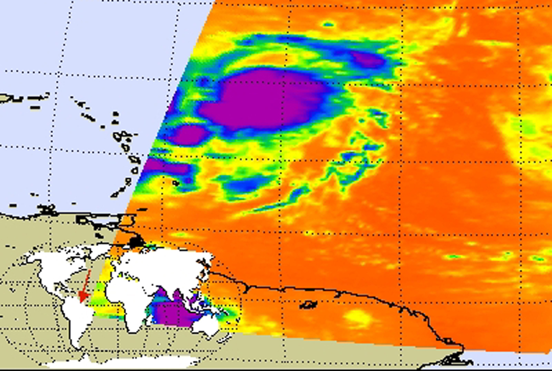
Tropical Storm Hanna's Towering Thunderclouds

NASA's TRMM spacecraft observed this view of Tropical Storm Hanna on September 1, 2008 at 1418 UTC (10:18 EDT). At this time the storm was a tropical storm with sustained winds of 50 knots (57.5 mph) and a pressure reading of 994 millibars. Three hours later, The National Hurricane Center upgraded this storm to a category 1 hurricane with sustained winds of 70 knots and a pressure reading of 984 millibars. TRMM documented one reason for this rapid intensification - strong thunderstorms with heights of over 17 kilometers (10.5 miles) in the eastern eyewall of this tropical storm. The cloud cover is taken by TRMM's Visible and Infrared Scanner(VIRS) and the GOES spacecraft. The rain structure is taken by TRMM's Tropical Microwave Imager (TMI) and TRMM's Precitation Radar(PR) instruments. TRMM looks underneath of the storm's clouds to reveal the underlying rain structure. The rain structure is colored by the height of the clouds.
> View and download Hanna animations
Sept. 3, 2008, second update
Hanna and Her Sister
 Tropical storms Hanna, left, and Josephine. Image credit: NASA/JPL
> Hanna (full resolution) | > Josephine (full resolution) While Tropical Storm Hanna moves toward the Bahamas, in the eastern Atlantic, her younger sister, Tropical Storm Josephine, begins her westward trek in these Sept. 3 infrared images from NASA's Aqua spacecraft.
Sept. 3, 2008, first update
Tropical Storm Hanna Ambling Northward Into the Southern Bahamas
 Credit: Hal Pierce (SSAI/NASA GSFC)
> Larger image Tropical Storm Hanna is now forecast to make landfall in South Carolina very late Friday night, Sept. 5, but for now, she's leaving Hispaniola and meandering her way through the southern Bahamas. Meanwhile, from now through the weekend, the U.S. East Coast is dealing with dangerous ocean swells from Hanna.
NASA's TRMM Satellite Checks Out Hanna's Rainfall from Space
The image above was made from data captured by the Tropical Rainfall Measuring Mission (TRMM) satellite on August 2 at 13:22 UTC (9:22 a.m. EDT). This TRMM image shows the horizontal pattern of rain intensity within Hanna. The center is located near the yellow, green and red areas, which indicate rainfall between 20 and 40 millimeters (.78 to 1.57 inches) per hour. The red area is considered moderate rainfall. In the image, Hurricane Hanna is shown generating numerous strong thunderstorms over Hispaniola. Very high thunderstorm towers are being produced due to interaction with the mountains over Haiti.
For more information about how TRMM looks at rainfall, visit NASA's TRMM website at: http://trmm.gsfc.nasa.gov/. TRMM is a joint mission between NASA and the Japanese space agency JAXA.
 Credit: NASA JPL
> Larger image NASA's Aqua Satellite Shows the Extent of Hanna's Cloud Cover
This infrared image of Hanna was created by data from the Atmospheric Infrared Sounder (AIRS), an instrument that flies aboard NASA's Aqua satellite. The image was created on Sept. 2 at 17:59 UTC (1:59 a.m. EDT).
The AIRS image shows the temperature of the cloud tops or the surface of the Earth in cloud-free regions, and you can see the extent to which Hanna's clouds stretch. The lowest temperatures (in purple) are associated with high, cold cloud tops that make up the top of Hanna. The AIRS data creates an accurate 3-D map of atmospheric temperature, water vapor and clouds, all of which are helpful to forecasters.
The infrared signal of the AIRS instrument does not penetrate through clouds. Where there are no clouds the AIRS instrument reads the infrared signal from the ocean and land surfaces, revealing warmer temperatures in orange and red.
Where is Hanna on Sept. 3?
At 8:00 a.m. EDT, Wed. Sept. 3, Hanna is sitting of the northern coast of Haiti. She has maximum sustained winds near 60 mph, and may again become a hurricane on Sept. 4. Meanwhile, she's located near 20.3 degrees north latitude and 71.8 degrees west longitude. That puts her center about 105 miles southeast of the Great Inagua Island. She's moving around 5 mph to the east, but will turn northwest later today, Sept. 3. Her minimum central pressure is 996 millibars. The southeastern Bahamas, Turks and Caicos Islands, and eastern Cuba can expect rainfall today between 4 and 8 inches, with isolated totals up to 12 inches. Slightly higher amounts can be expected over Hispaniola today.
Georgia, South Carolina Preparing
South Carolina Governor Mark Sanford's office reported to WIS-TV News that "Coastal evacuations are possible and the National Guard could be activated." In Georgia voluntary evacuations of Georgia’s barrier islands and low-lying coastal areas may begin today, Wednesday, Sept. 3. Meanwhile, federal, state and local emergency response teams, the American Red Cross were already preparing for Hanna's arrival.
Text credit: Rob Gutro, NASA's Goddard Space Flight Center
Sept. 2, 2008
 > Full resolution
Image credit: NASA JPL
Hanna Goes to Haiti
> Full resolution
Image credit: NASA JPL
Hanna Goes to Haiti Tropical Storm Hanna follows in Gustav's footsteps, affecting Haiti and the Dominican Republic in this Sept. 2 afternoon infrared image from NASA's Aqua satellite. Hanna is expected to become a hurricane tomorrow and may affect the entire U.S. eastern seaboard by this weekend.
Tropical Storm Hanna Next Big Threat to U.S., Now Affecting Southern Bahamas
The southern Bahamas, and Turks and Caicos islands are now under the gun as Tropical Storm Hanna brings drenching rains. By the end of the week, however, Hanna will be a memory there and is expected to make landfall in South Carolina.
Before Hanna even reaches the U.S., she's creating dangerous rip currents along the southeastern U.S. coast today and over the next couple of days.
On Monday, Sept. 1, Hanna strengthened to a Category One hurricane on the Saffir-Simpson scale after being freed from Hurricane Gustav's influence. Now, a day later, she's weakened a little to a Tropical Storm while battering the southeastern Bahamas, Turks and Caicos Islands, and as far south as Haiti with very heavy rainfall.
On Sept. 2, at 8:00 a.m. EDT Hanna's maximum sustained winds have decreased to 70 mph, but she could become a hurricane again later today or tomorrow. Estimated minimum central pressure is 987 millibars.
Hanna's center was near latitude 21.2 north and longitude 73.1 west or very near Great Inagua Island and about 385 miles southeast of Nassau. She's drifting west at 2 mph, and will continue to meander today over the southeastern Bahamas. By tonight, she'll get on a northwest track and move over the central Bahamas.
Just as with Fay and Gustav, the rains are the big story. Rainfall will range from 8 to 12 inches, and isolated areas can receive as much as 20 inches over the southeastern Bahamas, Turks and Caicos Islands. The central Bahamas may see as much as 8 inches of rainfall today.
NASA's Aqua Satellite Captures Hanna's Cold Clouds
 > Larger image
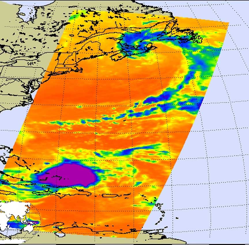
Credit: NASA JPL This infrared image of Hanna was created by data from the Atmospheric Infrared Sounder (AIRS), an instrument that flies aboard NASA's Aqua satellite. It was created on Monday, Sept. 1 at 6:17 UTC (2:17 a.m. EDT).
The infrared AIRS image shows the temperature of the cloud tops or the surface of the Earth in cloud-free regions. The lowest temperatures (in purple) are associated with high, cold cloud tops that make up the center of Hurricane Hanna. The AIRS data creates an accurate 3-D map of atmospheric temperature, water vapor and clouds, all of which are helpful to forecasters. "Now that the outflow from Gustav that Hanna has been "eating" has diminished, Hanna has consolidated (and was able to become a hurricane on Sept. 1)," said Edward Olsen of NASA's Jet Propulsion Laboratory, Pasadena, Calif.
The infrared signal of the AIRS instrument does not penetrate through clouds. Where there are no clouds the AIRS instrument reads the infrared signal from the surface of the ocean waters, revealing warmer temperatures in orange and red. To the far north of Hanna, near New England, the swirl of blue and purple is a low pressure system exiting the U.S. east coast.
CloudSat Looks at Hanna Sliced in Half
 > Larger image
Credit: NASA/JPL/Colorado State University/Naval Research Laboratory-Monterey NASA's CloudSat satellite's Cloud Profiling Radar captured a sideways look across Hanna on Aug. 31 at 18:16 UTC (4:16 p.m. EDT). For comparison, the top image is from the National Oceanic and Atmospheric Administration's Geostationary Operational Environmental Satellite (GOES-12) around the same time.
The red line through the GOES satellite image shows the vertical cross section of radar, basically what Hanna's clouds looked like sideways. The colors indicate the intensity of the reflected radar energy. The top of Hanna's clouds are over 15 kilometers (9.3 miles) high.
The blue areas along the top of the clouds indicate cloud ice, while the wavy blue lines on the bottom center of the image indicate intense rainfall. Notice that the solid line along the bottom of the panel, which is the ground, disappears in this area of intense precipitation. It is likely that in the area the precipitation rate exceeds 30mm/hr (1.18 inches/hour) based on previous studies.
Text credit: Rob Gutro, NASA's Goddard Space Flight Center
Sept. 1, 2008, second update
TRMM Captures Hanna
 Credit: SSAI/NASA, Hal Pierce
> Larger image Tropical storm Hanna was captured using data from the Tropical Rainfall Measuring Mission (TRMM) satellite on August 1, 2008 at 1418 UTC (10:18 AM EDT). Hanna was upgraded to a hurricane by the National Hurricane Center at 1730 UTC (1:30 PM EDT). Heavy thunderstorms with heights of over 10.5 miles (17 km) were observed by the TRMM Precipitation Radar (PR) in the eastern side of Hanna.
The Tropical Rainfall Measuring Mission (TRMM) is a joint mission between NASA and the Japan Aerospace Exploration Agency (JAXA) designed to monitor and study tropical rainfall.
Text credit: Hal Pierce, NASA's Goddard Space Flight Center/SSAI
Sept. 1, 2008, first update
Hanna Not Moving Much Near North of the Caicos Islands
 > Larger image
Credit: NASA/JPL Tropical Storm Hanna has virtually parked herself north of the Caicos Islands in the Atlantic Ocean, continuing to bring residents heavy rains and winds. A tropical storm warning remains in effect for the central and southeastern Bahamas and the Turks and Caicos islands.
This visible image of Hanna was created by data from the Atmospheric Infrared Sounder (AIRS), an instrument that flies aboard NASA's Aqua satellite. It was created on August 31 at 18:11 UTC (2:11 p.m. EDT).
At 8:00 a.m. EDT the center of Tropical Storm Hanna had maximum sustained winds near 50 mph. She was located near latitude 23.6 north and longitude 72.4 west or about 90 miles north-northeast of the southeastern Bahamas. She's been nearly stationary, drifting westward near 2 mph and will continue that way for the next day or two. On the forecast track the center of Hanna will move near or over the southeastern Bahamas during the next day or two. The estimated minimum central pressure is 996 millibars.
Rainfall expected through Thursday over the central and Southeastern Bahamas and the Turks and Caicos islands will be between 4 to 8 inches with maximum amounts near 12 inches. In addition, ocean swells are expected to increase the risk of dangerous rip currents along portions of the southeastern United States coast during the next couple of days.
Text credit: Rob Gutro, NASA's Goddard Space Flight Center
August 31, 2008
Tropical Storm Hanna Appears to Again Threaten U.S. East Coast
Tropical Storm Hanna is keeping forecasters on their toes. On Friday, Aug 29, she seemed headed toward the U.S. East Coast. On Saturday, it appeared a high pressure system that is intensifying may shoot her into the Gulf of Mexico. On Sunday, it appears that high may be moving enough and not strengthening enough to push her Gulf-ward and allow her to move toward the U.S. East Coast. She appears now to be on a short-term track through the Bahamas, Turks and Caicos.
Lots of Meteorological Factors Come into Hanna's Track
According to the National Hurricane Center discussion, "nearly all of the (computer forecast) models forecast the strong upper-trough to lift out to the Northeast and be replaced by a large ridge to the north and east of Hanna. The latter feature is expected to gradually induce a northwestward component of motion by days 4 and 5. The key to the forecast track at those forecast times will be just how far south and west Hanna moves before it begins to move northwestward. The bottom line is that everyone in the southeast U.S. coastal areas needs to be on guard for Hanna. Not only for her possible approach, but for dangerous rip currents that she will be creating over the next several days along U.S. east coast beaches.
 > Larger image
Credit: NASA/Hal Pierce At 8:00 a.m. EDT, Hanna's maximum sustained winds are near 60 mph with higher gusts. Little change in strength is expected during the next couple of days. Hanna's center was located about 155 miles northeast of Grand Turk Island, near latitude 23.2 north and longitude 69.5 west. She's moving west-northwest near 12 mph, taking her north of the Turks and Caicos Islands later today and tonight. Estimated minimum central pressure is 999 millibars.
Checking Rainfall in Hanna
The image above was made from data captured by the Tropical Rainfall Measuring Mission (TRMM) satellite on August 30 at 14:33 UTC (10:33 a.m. EDT). This TRMM image shows the horizontal pattern of rain intensity within Hanna. The center is poorly defined and is located near the yellow, green and red areas, which indicate rainfall between 20 and 40 millimeters (.78 to 1.57 inches) per hour. The very tiny red areas are considered moderate rainfall.
For more information about how TRMM looks at rainfall, visit NASA's TRMM website at: > TRMM. TRMM is a joint mission between NASA and the Japanese space agency JAXA.
The Aqua Satellite Catches a Visible View
 > Larger image
Credit: NASA/JPL This visible image was created by data from the Atmospheric Infrared Sounder (AIRS), an instrument that flies aboard NASA's Aqua satellite. It was created on August 30 at 17:29 UTC (1:29 p.m. EDT).
The visible image confirms what the TRMM image showed, and that is a very poorly organized center. It seems that most of the clouds and precipitation are on the northeast and eastern sides of the storm at this time.
For updates on Hanna's Track, visit: > National Hurricane Center
Text credit: Rob Gutro, NASA's Goddard Space Flight Center
August 30, 2008
Hanna Now Looks Like Another Gulf of Mexico Storm Due to a Developing High
 CLOUDSAT Image credit: NASA/JPL/Colorado State University/Naval Research Laboratory-Monterey
> Larger image Over the last couple of days, the forecast track of Tropical Storm Hanna has changed. Several days ago, the forecast models were taking her on a possible track toward Florida, now, forecast models agree that she'll be taking a southeast track toward Cuba.
An intensifying subtropical high pressure system is the reason for Hanna's change in track. It's located to the north-northwest of Hanna, and because High pressure systems have a clockwise wind flow, it will steer Hanna downward on a west-southwest track from heading to an almost a 3 o'clock position (due west of where it is now) to a 6 o'clock position (southward).
Who Will be Affected By Hanna?
In the short term, The Bahamas, Turks and Caicos are under the gun for Tropical Storm conditions, but the southeastern U.S. coast is going to deal with dangerous rip currents over the next couple of days. Beachgoers in all of these areas should take serious precautions.
CloudSat Looks at Hanna Sliced in Half
NASA's CloudSat satellite's Cloud Profiling Radar captured a sideways look across Hanna on Aug. 29 at 6:15 UTC (2:15 a.m. EDT). For comparison, the top image is from the National Oceanic and Atmospheric Administration's Geostationary Operational Environmental Satellite (GOES-12) around the same time.
The red line through the GOES satellite image shows the vertical cross section of radar, basically what Fay's clouds looked like sideways. The colors indicate the intensity of the reflected radar energy. The top of Fay's clouds are over 14 kilometers (8.5 miles) high.
The blue areas along the top of the clouds indicate cloud ice, while the wavy blue lines on the bottom center of the image indicate intense rainfall. Notice that the solid line along the bottom of the panel, which is the ground, disappears in this area of intense precipitation. It is likely that in the area the precipitation rate exceeds 30mm/hr (1.18 inches/hour) based on previous studies.
Where is Hanna on Saturday, August 30, 2008?
Tropical storm watches have been issued for portions of the Bahamas and the Turks and Caicos Islands. At 11 a.m. EDT, the government of the Bahamas has issued a tropical storm watch for the southeastern Bahamas.
At 11:00 a.m. EDT Hanna's center was near latitude 21.9 north and longitude 66.4 west or about 240 miles north of San Juan, Puerto Rico and about 305 miles east of Grand Turk Island. Hanna has slowed from 12 to 8 mph westward and will gradually turn west-northwest before heading back in a westerly direction on Aug. 31.
Hanna's maximum sustained winds remain near 50 mph with higher gusts. Little change in strength is forecast today but Hanna could be near hurricane strength on Sunday. Estimated minimum central pressure has dropped from1001 to 1000 millibars, which is a slight indication of strengthening. The Leeward Islands could receive between 1 and 2 inches of rainfall as Hanna passes by.
Text credit: Rob Gutro, NASA's Goddard Space Flight Center
Aug. 29, 2008
Tropical Storm Hanna moving Away from Leeward Islands
 Credit: NASA JPL
> Larger image At 5:00 a.m. EDT, the center of Tropical Storm Hanna was located near latitude 21.7 north and longitude 62.3 west or about 245 miles north-northeast of the northern Leeward Islands.
Hanna is moving toward the northwest near 14 mph and will move west-northwest and northwest away from the Leeward Islands. Maximum sustained winds are near 50 mph. Little change in strength is forecast today but Hanna could become a hurricane in a couple of days. Estimated minimum central pressure is 1000 millibars.
This infrared image of Hanna was created by data from the Atmospheric Infrared Sounder (AIRS), an instrument that flies aboard NASA's Aqua satellite. The image was created on August 29 at 5:53 UTC (1:53 a.m. EDT).
The AIRS image shows the temperature of the cloud tops or the surface of the Earth in cloud-free regions. The lowest temperatures (in purple) are associated with high, cold cloud tops that make up the top of Hanna. The infrared signal of the AIRS instrument does not penetrate through clouds. Where there are no clouds the AIRS instrument reads the infrared signal from the ocean and land surfaces, revealing warmer temperatures in orange and red.
Text credit: Rob Gutro, NASA's Goddard Space Flight Center
Aug. 28, 2008, third update
Hanna and Gustav in the Atlantic
 Credit: NASA/NOAA GOES Project
> Larger image This satellite image from the Geostationary Operational Environmental Satellite (GOES-12) was created on August 28, when Tropical Storm Gustav was near Kingston, Jamaica, and Tropical Storm Hanna was about 305 miles away from the northern Leeward Islands.
Text credit: NOAA
Aug. 28, 2008, second update
Tropical Depression Eight Becomes Tropical Storm Hanna
 Credit: NASA JPL
> Larger image It didn't take long for the eighth tropical depression in the Atlantic Ocean to warm up and strengthen into Tropical Storm Hanna.
The National Hurricane Center noted that there's an upper level low pressure system (not on the surface) to the west of Hanna that is impacting the system (keeping it from becoming stronger), but the warmer waters have allowed her to strengthen.
At 11:00 a.m. EDT on Aug. 28, Hanna's maximum sustained winds are near 40 mph with higher gusts. Some strengthening is forecast during the next 24 hours. Tropical Storm Hanna's center was located near latitude 20.5 north and longitude 59.2 west or about 305 miles northeast of the northern Leeward Islands. Hanna is moving toward the west-northwest near 12 mph and will turn northwest later today. Minimum central pressure was 1002 millibars.
This infrared image was created by data from the Atmospheric Infrared Sounder (AIRS), an instrument that flies aboard NASA's Aqua satellite. The image was created on August 28 at 5:05 UTC (1:05 a.m. EDT).
The AIRS images show the temperature of the cloud tops or the surface of the Earth in cloud-free regions. The lowest temperatures (in purple) are associated with high, cold cloud tops that make up the top of Hanna. The AIRS data creates an accurate 3-D map of atmospheric temperature, water vapor and clouds, all of which are helpful to forecasters.
The infrared signal of the AIRS instrument does not penetrate through clouds. Where there are no clouds the AIRS instrument reads the infrared signal from the surface of the ocean waters, revealing warmer temperatures in orange and red.
Text credit: Rob Gutro, NASA's Goddard Space Flight Center
Aug. 28, 2008, first update
Atlantic Hurricane Season Kicks Into High Gear with Eighth Tropical Depression
 Credit: NOAA/NASA GOES Project
> Larger image On Thursday, August 28, Forecasters were busy. As Fay's remnants rain on the Mid-Atlantic and U.S. northeast, and Hurricane Gustav is on a deadly path into the Gulf of Mexico, the eighth tropical depression formed in the Atlantic.
At 5:00 a.m. EDT, the center of newly formed Tropical Depression Eight (TD8) was located near latitude 19.8 north and longitude 57.9 west or about 355 miles east-northeast of the Northern Leeward Islands. TD8 is expected to pass far north of the Northern Leewards on its 5 mph track west-northwest. It is expected to turn toward the northwest later today, Aug. 28, however. Estimated minimum central pressure is 1004 millibars.
Maximum sustained winds are near 35 mph with higher gusts, and forecasters at the National Hurricane Center said it could become Tropical Storm Hanna later today or Friday.
This satellite image was captured on August 28 at 1:23 UTC (9:23 a.m. EDT from the Geostationary Operational Environmental Satellites (GOES-11 and GOES-12). In the image, the surface Low pressure area that was Fay is the area of clouds over the mid-Atlantic that stretch northward, Hurricane Gustav is in the lower left as he heads toward Jamaica, and in the lower left is Tropical Depression 8.
GOES is operated by the National Oceanic and Atmospheric Administration. It was created by NASA's GOES Project, located at NASA's Goddard Space Flight Center, Greenbelt, Md.
Text credit: Rob Gutro, NASA's Goddard Space Flight Center