| 1 |  |
Aggregate hailstone. Large hailstone with smaller stones visible. Ruler shows radius of this remarkable hail stone. Diameter is approximately 6 centimeters - the size of a baseball. |
|
2 |  |
Large hailstone with diameter of approximately 4" (softball size). Smaller stones are collected together to form this large stone. |
Ada, Oklahoma April 29, 1978 |
3 |  |
Large hail collects on streets and grass during severe thunderstorm. Larger stones appear to be nearly 2 to 3 inches in diameter. |
|
4 |  |
Neighbors and friends work to remove debris around remains of a farmhouse. Large tornado devastated area. |
Union City, Oklahoma May 24, 1973 |
5 | 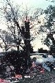 |
Tornado leaves a path of damage to treetops and windswept homes. Here windswept debris is collected against a fence. |
Newkirk, Oklahoma April, 1978 |
6 |  |
Tornado crushes and rolls farm vehicle, pinning it against a post. |
Verden, Oklahoma April 1965 |
7 |  |
Remains of a home. A tornado destroyed everything except the innermost bathroom. |
Tulsa, Oklahoma |
8 |  |
Damage to a farm caused by an April, 1978 Newkirk, Oklahoma tornado. |
Newkirk, Oklahoma April 18, 1978 |
9 |  |
Damage caused by Union City Tornado. |
Union City, Oklahoma May 24, 1973 |
10 |  |
Multiple cloud-to-ground and cloud-to-cloud lightning strokes during night-time. Observed during night-time thunderstorm. |
|
11 |  |
A cloud-to-ground lightning stroke originating from higher based cloud structure . Lightning stroke penetrates a low level cloud before reaching earth. |
Norman, Oklahoma |
12 |  |
Multiple cloud-to-cloud and cloud-to-ground lightning strokes caught using time-lapse photography during a night-time thunderstorm. |
|
13 |  |
Time-lapse photography captures cloud-to-ground lightning during a night-time thunderstorm in Norman, Oklahoma - home of the NSSL. |
Norman, Oklahoma March 1978 |
14 |  |
Storm clouds from night-time thunderstorm. Illuminated by cloud-to-cloud lightning. |
|
15 |  |
Storm clouds and bands of rain. Illuminated by lightning within a night-time thunderstorm. |
|
16 |  |
Time-lapse photography captures multiple cloud-to-ground lightning strokes during a night-time thunderstorm. |
Norman, Oklahoma March, 1978 |
17 |  |
Time-lapse photography captures multiple cloud-to-ground lightning strokes during a night-time thunderstorm. |
Norman, Oklahoma March 1978 |
18 |  |
Intense cloud-to-ground lightning Caught using time-lapse photography during a night-time thunderstorm. |
Norman, Oklahoma March 1978 |
19 |  |
Large rawinsonde balloon is released in foreground It will measure atmospheric conditions during ascent. In the background are surface weather instruments. These measure temperature, relative humidity, pressure and precipitation. A mobile radar unit is also shown. |
|
20 |  |
Rawinsonde weather balloon just after launch. Notice a parachute in the center of the string and a small instrument box at the end. After release it measures many parameters. These include temperature, relative humidity, pressure, and wind speed. This information is transmitted back to surface observers. |
|
21 |  |
The National Severe Storms Laboratory (NSSL) research facility with radar dome in the background. |
Norman, Oklahoma Ca. 1970 |
22 |  |
NSSL's first Doppler Weather Radar located in Norman, Oklahoma. 1970's research using this radar led to NWS NEXRAD WSR-88D radar network. |
Norman, Oklahoma April 1973 |
23 |  |
NSSL's second Doppler Weather Radar, 15 miles west of Oklahoma City. Researchers used this radar and the Norman Doppler radar to study thunderstorms. Doppler radar gave better estimates of winds within storms than earlier radars. |
Cimarron, Oklahoma |
24 |  |
NSSL used this equipment to detect, analyze, and map lightning strikes. Lightning studies were conducted during the late 1970s and 1980s. |
|
25 |  |
NSSL's first research Doppler Weather Radar. Radar dish in the foreground. Triangular panels of protective fiberglass radar dome in the background. |
|
26 |  |
NSSL's first research Doppler Weather Radar. Radar dish in the foreground. Triangular panels of protective fiberglass radar dome are in the background. The dish has a 30-foot diameter. |
December 1971 |
27 |  |
Standard instrument shelter (called a Stevenson Screen) used by NSSL. Shelter houses temperature, pressure, and relative humidity instruments. Observer comes to shelter to take readings. The shelter is a wooden box painted white with double-louvered sides. It is mounted on a stand 4 feet above the ground. |
|
28 |  |
A solar-powered Surface Automated Measurement (SAM) site. These are deployed to take measurements in and around severe weather. Tower instruments give wind direction and speed; rain gauge on left. White box houses temperature, relative humidity and pressure instruments. |
|
29 | 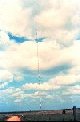 |
NSSL researchers mounted weather instruments on this very tall TV tower. This was the WKY-TV, Oklahoma City, 1602' tower. This tower was used during the 1970's and 1980's. |
Oklahoma City, Oklahoma |
30 | 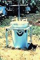 |
During the early 1980s, NSSL and University of Oklahoma researchers place TOTO (TOtable Tornado Observatory) in the path of an on-coming tornado. It would measure temperature, pressure, relative humidity etc. It would record the data on tape inside the 55 gallon drum. TOTO was hit by a small tornado only once in April, 1985. |
April, 1985 |
31 |  |
NSSL researchers test new multi-moment Doppler Radar display in the late 1970's. A large complex of thunderstorms is passing near the radar. |
|
32 |  |
Schematic of the components of a potentially tornadogenic thunderstorm. |
|
33 |  |
Cumulus clouds forming over water. Some clouds appear to be developing into a thunderstorm. |
|
34 |  |
Globular mammatus clouds with radar in foreground. Often associated with thuderstorms and severe weather. |
|
35 |  |
Anvil of large cumulonimbus thunderhead during early stages of developing storm. |
|
36 |  |
Building line of cumulonimbus thunderstorms. View is from behind storms during early stages of development. |
|
37 |  |
NSSL Doppler with rainshaft nearby. If you don't believe the radar, look out the window. |
May, 1976 |
38 |  |
Description not available. |
|
39 |  |
An anti-cyclonic circulation was observed in this tornado. |
West of Alva, Oklahoma June 6, 1975 |
40 |  |
Dust Storm |
|
41 |  |
Approaching thunderstorm with lead gust front. Rain-cooled air from the storm moves out ahead of the storm. It ploughs under the warm moist air forming a flat"shelf cloud." |
1982 |
42 |  |
Globular mammatus clouds with radar in foreground. Often associated with thunderstorms and severe weather. |
June, 1970 |
43 |  |
Towering cumulus. Mammatus clouds visible under the"anvil". |
|
44 |  |
Wall cloud - Towering cumulus with rain-free base. A wall cloud, a lowering of the cloud base underneath main storm updraft, forms in this thunderstorm. Tornadoes can form out ot the wall clouds. |
1982 |
45 |  |
Approaching thunderstorm with lead gust front. Rain-cooled air from the storm moves out ahead of the storm. It ploughs under the warm moist air forming a flat"shelf cloud." |
Brookhaven, New Mexico 1982 |
46 |  |
Cumulonimbus (Thunderstorm) forming in background. Smaller low level"scud"appearing in foreground. |
|
47 |  |
Isolated supercell south of Norman Ok. Photo taken from roof of NSSL. |
Norman, Oklahoma 1982 |
48 |  |
Isolated severe thunderstorm. Main updraft core is in the background, storm anvil is in upper foreground. |
Central Oklahoma 1982 |
49 |  |
Severe thunderstorm with a clear slot near main updraft core. Typically a tornado, if present, will form in this area. |
1982 |