|
Beginning Sunday evening, February 13 and continuing into the early morning hours of Monday, February 14, 2000, NWS WFO Tallahassee issued 52 warnings. These included 25 tornado, 24 severe thunderstorm, and 3 special marine warnings. During this time, warnings were issued for three deadly tornadoes, which caused the loss of 19 lives in three southwest Georgia counties, an event unequaled for south Georgia in nearly 50 years. The following is a preliminary assessment of the three deadly tornadoes that struck southwest Georgia early Monday morning.
The Camilla tornadic storm came ashore in extreme southeast Walton County, Florida, at approximately 0130 UTC (8:30pm EST). The cell rapidly developed a circulation and became Supercell #1. The storm was responsible for extensive damage in extreme northern Bay County around 0200 UTC (8:00pm CST) and southeastern Washington County around 0215 UTC (8:15pm CST) before continuing across the northeastern Florida Panhandle into Jackson County. It weakened slightly as it crossed Lake Seminole around 0400 UTC (11pm EST), the dividing line between Florida, Alabama, and Georgia. Supercell #1 then rapidly regained strength across Seminole County, Georgia, becoming tornadic around 0442 UTC (11:42pm EST) near Branchville, Georgia (Figure 1) and remaining tornadic (F3) as it passed just south of Camilla before dissipating around 0503 UTC (12:03am EST). This tornado was responsible for 11 deaths in the Camilla vicinity. An aerial view of some of the Camilla devastation can be seen in Figure 2.
Supercell #2 developed in western Seminole County at 0430 UTC (11:30pm EST). Supercell #2 can be observed in Figure 1 to the southwest of Supercell #1. This supercell ultimately developed a circulation nearly as intense as that of Supercell #1. Ironically, it followed almost exactly the same track as the Camilla tornado and could have been tornadic at 0529 UTC (12:29am EST) as shown in Figure 3. However, there is no evidence at this time that the circulation ever reached the ground. One can only speculate about the potential for an even greater disaster had this occurred.
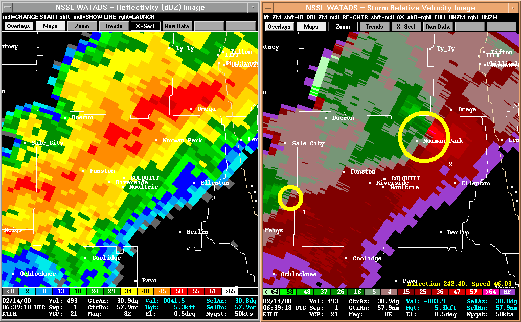
Supercell #3 also developed in southern Seminole County, Georgia, at about 0500 UTC (midnight EST). The storm rapidly developed on the heels of Supercell #2, exhibiting TVS signatures as it moved rapidly across Decatur County into Grady County. It became tornadic at 0549 UTC (12:49am EST) approximately 10 miles north of Cairo, and then passed along the northern outskirts of Meigs at 0600 UTC (1:00am EST). Figure 4 shows the storm just west of Meigs at 0552 UTC (12:52am EST). The mesocyclone then weakened and the tornado lifted northeast of Meigs. However, it reintensified at 0621 UTC (1:21am EST) just west of Moultrie, Georgia, in Colquitt County, and became tornadic again at 0639 UTC (1:39am EST; Figure 5) as it passed through Crosland and Omega, Georgia. The two tornadoes associated with this supercell resulted in six deaths north of Cairo in Grady County, one death north of Meigs in Mitchell County, and one death near Crosland in Colquitt County.
The damage paths of the three deadly tornadoes and their intensity based on the Fujita scale are found in Figure 6. A preliminary storm report can be found here.
|


