|
Tsunamis - General |  | Tsunami is a Japanese word meaning "harbor wave." It is a water wave or a series of waves generated by an impulsive vertical displacement of the surface of the ocean or other body of
water. This slide set depicts advancing waves, harbor damage, and structural damage from seven tsunami events which have occurred since 1946 in the Pacific region. The set includes before-and-after views of Scotch Cap Lighthouse (the Aleutian Islands).
View
Captions,
Thumbnails,
or
Slides,
|
|
Major Tsunamis of 1992 - Nicaragua and Indonesia |  | On September 1, 1992 (September 2 at 00:16 GMT), an earthquake
with a magnitude of 7.0 generated a tsunami with waves between
8 and 15 meters high that struck 26 towns along
250 km of Nicaragua's Pacific coast. More than 40,000 people
were affected by the loss of their homes or means of income.
The waves left 116 dead, 63 missing and another 489 injured.
On December 12, 1992, a 7.8 surface wave magnitude earthquake
occurred in the Flores region of Indonesia. Flores Island is
located about 1,800 km east of Jakarta. The death toll as a
result of the combined earthquake and tsunami effects was more
than 2,000. This slide set shows damage from the
September tsunami along Nicaragua's Pacific coast (6 slides)
and the December tsunami in the Flores region of Indonesia
(14 slides).
View
Captions,
Thumbnails,
or
Slides,
|
|
Hokkaido Nansei-Oki Tsunami, July 12, 1993 |  | On July 12, 1993, a magnitude 7.8 earthquake occurred off the west coast of Hokkaido and the small offshore island of Okushiri in the Sea of Japan. In two to five minutes the tsunami, one of
the largest in Japan's history, engulfed the coastline of Okushiri Island and the central west coast of Hokkaido. Almost two hundred fatalities were associated with the event, with more than half attributed to the tsunami. The $600 million in property losses were attributed primarily to the tsunami. This tsunami caused spectacular localized damage, especially on the southwestern
shores of Hokkaido and on Okushiri Island. This slide set shows damage to ships, dwellings, and businesses, and unique views of clocks stopped in time by the tsunami.
View
Captions,
Thumbnails,
or
Slides,
|
|
Shikotan, Kuril Islands Earthquake & Tsunami October 4, 1994 Set 1 | 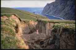 | A magnitude 8.1 earthquake occurred in the southern Kurils and on northern Hokkaido on Tuesday, October 5, 1994, (October 4 at 13:23 GMT). It was a sudden event, without any short-
term precursors or foreshocks. The earthquake epicenter was located 80 km east southeast of Shikotan Island. The slides in this set show views of a newly-created landslide formation, ground
cracks, structural damage, and effects of tsunami runup on Shikotan Island. The documentation
is a scientific overview of this event, written by a member of the international team that studied
it.
View
Captions,
Thumbnails,
or
Slides,
|
|
Shikotan, Kuril Islands Earthquake & Tsunami October 4, 1994 Set 2 |  | The first slide set of Shikotan, Kuril Islands focused on damage caused by the earthquake. This second set, depicts much of the tsunami damage that occurred. At Kuzhno-Kurilsk, Kunsashir Island, tsunami heights ranged from 2.5-3.0 m. In the older part of town (fronted by a gentle beach) all houses were damaged by the wave that penetrated 200-500 m inland. The photos and documentation in this set are from the publication entitled Geodynamics of Tectonosphere of the Pacific Eurasia Conjunction Zone. Russian Academy of Sciences, Far East Branch, Institute of Marine Geology and Geophysics, Yuzhno-Sakhalinsk, 1997.
View
Captions,
Thumbnails,
or
Slides,
|
|
Papua New Guinea Tsunami, July 17, 1998 |  | On the evening of Friday July 17, 1998, a magnitude Ms 7.1 earthquake
occurred near the northwest coast of Papua New Guinea 850 km
(510 miles) northwest of Port Moresby, the capitol of Papua New Guinea
(PNG). The earthquake, which occurred at 6:49 pm local time (08:49 GMT),
was followed by a series of three catastrophic tsunami waves that
devastated the villages of Sissano, Warupu, Arop (1 and 2) and Malol
on the north coast of PNG killing at least 2,182, injuring 1,000,
and displacing more than 10,000 people.
View
Captions,
Thumbnails,
or
Slides,
|
|
Great Chile Earthquake of May 22, 1960 - Anniversary Edition |  | On May 22, 1960, a Mw 9.5 earthquake, the largest earthquake ever instrumentally recorded, occurred in southern Chile. The series of earthquakes that followed ravaged southern Chile and ruptured over a period of days a 1,000 km section of the fault, one of the longest ruptures ever reported. The number of fatalities associated with both the tsunami and the earthquake has been estimated to be between 490 and 5,700. Reportedly there were 3,000 injured, and initially there were 717 missing in Chile. The Chilean government estimated 2,000,000 people were left homeless and 58,622 houses were completely destroyed. Damage (including tsunami damage) was more than $500 million U.S. dollars. The main shock setup a series of seismic sea waves (tsunami) that not only was destructive along the coast of Chile, but which also caused numerous casualties and extensive property damage in Hawaii and Japan, and which was noticeable along shorelines throughout the Pacific Ocean area. There were several other geologic phenomena besides tsunamis associated with this event. Subsidence caused by the earthquake produced local flooding and permanently altered the shorelines of much of the area in Chile impacted by the earthquake. Landslides were common on Chilean hillsides. Cordón Caulle erupted forty-seven hours after the main shock. It is only a matter of time until Chile once again has a "world-class" earthquake whose impact, like the 1960 Chile event, will be felt around the world.
View
Captions,
Thumbnails,
or
Slides,
|
|
Tsunami Damage, Solomon Islands, April 1, 2007 |  | An earthquake measuring 8.1 struck 345km northwest of the Solomon Islands' capital Honiara at 0740 local time on 2 April. (2040 GMT 1 April). The earthquake created a tsunami causing significant damage in the Solomon Islands. Large tsunami waves (reports range from 2m to 10m) are reported to have struck the islands in the Western Province area of Solomon Islands and some parts of Papua New Guinea. The National Disaster Council (NDC) in the Solomon Islands reports that the affected area includes Gizo, Simbo, Ranogga, Shortlands, Munda, Noro, Vella la Vella, Kolombangarra and parts of the southern coast of Choiseul. Aerial surveillance on 2 April showed that the worst-affected areas appear to be the southern coast of Gizo, Simbo island and the central southern coast of Choiseul between Moli and Posarae and Sasamunga. At least 34 were killed and several dozen missing. 5,500 people are thought to have been displaced in total. The Ministry of Health and Medical Services (MHMS) estimates that up to 50,000 people may be affected out of a total population of 100,000 in Western and Choiseul provinces.
View
Captions,
Thumbnails,
or
Slides,
|
|
Tsunami Damage, Indian Ocean December 26, 2004 |  | The tsunami generated by the earthquake off the coast of northern Sumatra was recorded nearly world-wide and killed more people than any other tsunami in recorded history. More than 297,248 people were either killed or listed as missing and presumed dead and 1,126,900 were displaced by the earthquake and subsequent tsunami. The estimated economic losses exceed $10 billion.
View
Captions,
Thumbnails,
or
Slides,
|
|
April 1, 1946 Unimak Island, AK Earthquake and Tsunami |  | On April 1, 1946, at 12:29 [local time] a rather strong magnitude 7.4 earthquake occurred with source to the south of Unimak Island, causing one of the most destructive tsunamis in the Pacific Ocean.
View
Captions,
Thumbnails,
or
Slides,
|
|
|
|
