Extreme Atlantic Swell Event of March 2008
(A higher resolution image is available by selecting
the image of interest.)
Synopsis
On the night of Saturday, March 15, 2008, a strong short wave trough
and accompanying surface low moved quickly off of the mid-Atlantic
coast of the U.S. This deep layered feature slowed its forward motion
and deepened to 984 mb, as it moved east northeastward into the
northwest Atlantic by 00Z, March 17, 2008.
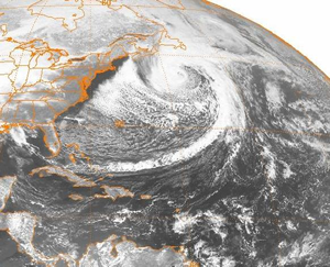
Figure 1: Satellite imagery of a
large surface low deepening off the northeast coast of the United
States taken on March 17, 2008 at 0000Z.
This large surface low then deepened rapidly during the next 24
hours, to 964 mb by 00Z on the 18th, and then drifted northeast
through the 20th, before eventually weakening significantly and
shifting southeastward across the central Atlantic. The nearly stalled
nature of the synoptic feature allowed for a very strong and broad
north to northwest wind fetch to spread from the Canadian Maritimes
and the northeastern U.S. coastline south and southeastward across
the west central Atlantic, to nearly 25 degrees north.
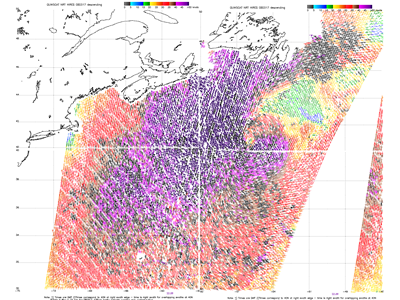
Figure 2: Satellite-derived winds from QuikScat imagery
reveal extremely strong counterclockwise flow around the center
of the deepening low pressure system. The deep purple wind barbs
across the center of the image reveal winds in excess of 50 knots
(nearly 60 mph).
A strong and dynamic wind fetch associated with this expanding
wind field produced extreme wave growth, and spread large and very
long period swells propagating across the entire regional Atlantic,
to the Bahamas, across the Greater and Lesser Antilles, to the northeast
coast of South America, and across the entire tropical Atlantic,
continuing to the west African coast and into the south Atlantic.
Locally across Puerto Rico and the U.S. Virgin Islands, extreme
breaking wave heights of 20 to 30 feet were common from early on
the 19th through the 21st, with occasional breaking waves reaching
35 to 40 feet and higher across the outer reef lines.
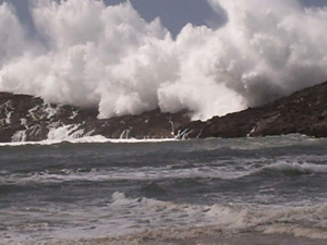
Figure 3: Waves crashing across
an outer reef along the north coast of Puerto Rico.

Figure 4: An impressive breaking
wave near the outer reef along the northwestern coast of Puerto
Rico.
These swells rivaled the swell event produced by the “Perfect
Storm” of October 1991, which killed two teens on the island
in its aftermath. Recent regional wave history suggests that this
size and wave length has a return period of 15 to 20 years.
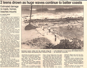
Figure 5: Newspaper article on the aftermath of
the coastal flooding event of October 1991.
Next page...
|

 National Weather Service Forecast Office


