Arlene, the first tropical storm of the 1999 Atlantic hurricane season, spent
its life at sea in the central Atlantic. Arlene passed roughly 100 n mi east
of Bermuda, but did not bring tropical storm force winds to the islands.
a. Synoptic History
During its initial stages of development Arlene was not a purely tropical
system. Although initially cold-core, by the time depression status had been
attained on 11 June, the overall structure more-closely resembled a tropical,
rather than a subtropical cyclone. At some (unknown) point, the system
became warm-core, as revealed by reconnaissance data on the 15th.
Arlene's complex development can be traced to a mid- to upper-level cold low
that developed near the tail end of a diffuse front in the central Atlantic.
Water-vapor imagery first showed the circulation of the upper low a
few-hundred miles north of Puerto Rico late on 8 June. Simultaneously, a
fairly large-amplitude tropical wave passed through the tail end of the
frontal zone southeast of the upper low, and a low-level cloud swirl became
visible near 22N, 61W, close to the wave axis, and southeast of the upper
low. The low-level cloud swirl then moved slowly north-westward over the
next two days without development due to westerly shear from the upper low.
Throughout this period, fairly steady convection had been maintained in the
diffluence region to the east of the upper low. By 0600 UTC on the
10th, the low-level circulation moved underneath the cold low,
near 24N, 63W. Shortly thereafter, the upper low began to move off to the
east into the convective area. As the upper low accelerated northeastward
late on the 10th, satellite microwave imagery revealed the rapid
downward development of a vortex in the convection, which led to the formation
of a new low-level center. During the morning of the 11th, the
convection acquired a well-defined banding pattern, and it is estimated that
a tropical depression formed at 1800 UTC on the 11th, about 465 n mi
southeast of Bermuda. The original low-level cloud swirl continued moving
away to the west and gradually dissipated.
The best track locations and intensities for Arlene are given in Table 1,
with the track plotted in Figure 1. Almost immediately after reaching
depression status, the cyclone slowed and began a northward drift for 24 h.
By 1200 UTC on the 12th, Dvorak satellite classifications from the
Tropical Analysis and Forecast Branch (TAFB) of the Tropical Prediction
Center and the NOAA/NESDIS Satellite Analysis Branch (SAB) indicated that
tropical storm strength had been attained. Arlene intensified for 12 h until
westerly shear began to expose the low-level circulation center. The maximum
intensity was reached at 0000 UTC on the 13th, when the winds were
estimated to be 50 kt and the minimum central pressure was estimated to be
1006 mb. From the 13th to the 15th, Arlene moved
generally west-northwestward while weakening slightly under the westerly
shear.
Steering currents became poorly defined and Arlene moved little on the
15th. The best track indicates that Arlene executed a small
cyclonic loop, although this apparent motion may have been due a reformation
of the center closer to the convection on the east side of the cyclone. A
northwesterly motion resumed late on the 15th, followed by a
gradual turn to the north then northeast over the next three days as Arlene
moved around the western edge of the subtropical ridge. Arlene's closest
approach to land was at 0600 on the 17th, when the cyclone passed
about 100 n mi to the east of Bermuda. Convection began to diminish on the
16th as the environmental shear changed to northeasterly and
Arlene moved over cooler waters. Synoptic-scale upper-level confluence and
subsidence in the immediate environment of Arlene also acted to suppress
convection. The low-level circulation weakened to depression status at
0000 UTC on the 17th, and dissipated ahead of an approaching
frontal zone on the 18th.
b. Meteorological Statistics
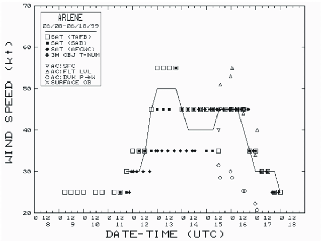
Figures 2 and 3 show the best track curves of maximum sustained surface wind
(defined as a 1 min average at an elevation of 10 m) and minimum central
pressure, respectively, as well as the observations on which the best track
estimates are based. There were no direct measurements of surface winds; the
best track values are based on interpretation of Dvorak satellite
classifications from TAFB, SAB, and the Air Force Weather Agency (indicated
by AFGWC in figure legends), as well as reductions of (mostly near 1000 ft)
flight-level reconnaissance winds.
There was only a limited amount of in-situ aircraft reconnaissance
data from the Air Force Reserve Hurricane Hunter Squadron, from 1200 UTC on
the 15th to 0000 UTC on the 17th. The maximum winds
from the reconnaissance aircraft were observed from 15/1200-16/0600 UTC, when
the surface winds were estimated to be 45 kt (Figure 2). As is typical for
storms in the subtropics, central pressures measured by reconnaissance were
somewhat higher than satellite-based estimates (Figure 3). Arlene's minimum
central pressure is estimated from satellite imagery and ship reports to be
1006 mb at 13/0000 UTC, although the lowest pressure measured by aircraft
reconnaissance was 1008 mb at 15/1200 UTC.
There are no known ship or land reports of winds in excess of 34 kt
associated with Arlene.
c. Casualty and Damage Statistics
There have been no reports of casualties or damage from Arlene.
d. Forecast and Warning Critique
Official forecast track errors for Arlene were 30, 55, 89, 101, and 99 n mi,
for the 12, 24, 36, 48, and 72 h forecasts, respectively. These errors are
30%-60% lower than the average official Atlantic basin errors for the period
1989-1998. Early forecasts did not capture the sharp turn to west. The
recurvature path was fairly well forecast, although there was a slight
westward bias (in the direction of Bermuda).
Arlene's intensity was generally overforecast, but with errors comparable to
the 1990-1997 period average. Arlene was briefly forecast to become a
hurricane. Intensity forecast errors during the second half of Arlene's
track were very low.
Tropical storm watches and warnings (Table 2) were issued for Bermuda;
however, Arlene passed sufficiently far to the east that no significant
weather affected the islands.

Figure 1.
Best track positions for Tropical Storm Arlene, 11-18 June 1999.

Figure 2.
Best track maximum sustained wind speed curve for Tropical Storm Arlene.
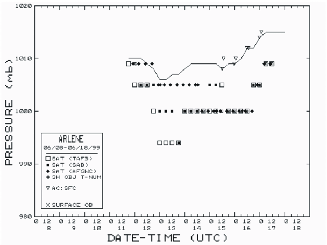
Figure 3.
Best track minimum central pressure curve for Tropical Storm Arlene.
Table 1.
Best track for Tropical Storm Arlene, 11-18 June 1999.
Date/Time
(UTC) |
Position |
Pressure
(mb) |
Wind Speed
(kt) |
Stage |
| Lat. (°N) |
Lon. (°W) |
| 11/1800 | 27.1 | 58.1 | 1010 | 30 | tropical depression |
| 12/0000 | 27.7 | 57.4 | 1010 | 30 | " |
| 12/0600 | 28.1 | 57.3 | 1010 | 30 | " |
| 12/1200 | 28.3 | 57.3 | 1009 | 35 | tropical storm |
| 12/1800 | 28.5 | 57.4 | 1008 | 45 | " |
| 13/0000 | 28.8 | 57.5 | 1006 | 50 | " |
| 13/0600 | 29.0 | 57.8 | 1006 | 50 | " |
| 13/1200 | 29.1 | 58.2 | 1007 | 50 | " |
| 13/1800 | 29.1 | 58.7 | 1007 | 50 | " |
| 14/0000 | 29.1 | 59.2 | 1008 | 45 | " |
| 14/0600 | 29.2 | 59.8 | 1009 | 40 | " |
| 14/1200 | 29.3 | 60.4 | 1009 | 40 | " |
| 14/1800 | 29.6 | 60.7 | 1009 | 40 | " |
| 15/0000 | 29.8 | 61.1 | 1009 | 40 | " |
| 15/0600 | 29.7 | 61.5 | 1009 | 40 | " |
| 15/1200 | 29.6 | 61.3 | 1008 | 45 | " |
| 15/1800 | 29.9 | 61.4 | 1009 | 45 | " |
| 16/0000 | 30.0 | 61.7 | 1009 | 45 | " |
| 16/0600 | 30.3 | 62.0 | 1010 | 45 | " |
| 16/1200 | 30.8 | 62.3 | 1012 | 40 | " |
| 16/1800 | 31.3 | 62.5 | 1012 | 35 | " |
| 17/0000 | 31.8 | 62.8 | 1014 | 30 | tropical depression |
| 17/0600 | 32.5 | 63.0 | 1015 | 30 | " |
| 17/1200 | 33.4 | 63.0 | 1015 | 30 | " |
| 17/1800 | 34.4 | 62.3 | 1015 | 30 | " |
| 18/0000 | 35.4 | 61.6 | 1015 | 25 | " |
| |
| 13/0000 | 28.8 | 57.5 | 1006 | 50 | minimum pressure |
Table 2.
Watch and warning summary for Tropical Storm Arlene, June 1999.
Date/Time
(UTC) |
Action |
Location |
| 14/1500 | tropical storm watch issued | Bermuda |
| 16/0600 | tropical storm warning issued | Bermuda |
| 17/0900 | tropical storm warning discontinued | Bermuda |
![[NCEP Logo]](graphics/ncep.gif)