|
Oil Spills: A Guided Tour
6 - Sensitivity Maps
Animals and plants that live in the water or along the coasts, and the habitats they depend on, are of special concern during spill response. At left is a photo of volunteers cleaning a common murre (Uria aalge) that was oiled during the Exxon Valdez spill. Birds like this one often do not survive oiling, even when they have been cleaned, so it is important to protect them from oiling whenever possible. Spill responders use our Environmental Sensitivity Index maps ("ESI maps") to see the locations of sensitive animal and plant populations, important historical sites, and other places important to people.
Below is a section of an ESI map, showing part of the Point Reyes National Seashore, California. Color coding and symbols mark sensitive locations.
On the map, shorelines are color-coded to show their sensitivity to oiling. For example, shorelines shown in red are salt marshes that are especially vulnerable to oil. Symbols mark locations important to spill responders, such as areas where seals or sea lions congregate or breed (marked with a sea lion symbol), areas where different kinds of birds (such as shorebirds, waterfowl, or raptors) concentrate for feeding or nesting, and areas used by people (such as an aquaculture facility, indicated on this map by an "AQ" symbol, and a recreational beach, marked by a sun umbrella).
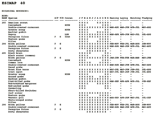
ESI maps also display more detailed information about species, habitats, and human-use areas, for use by response specialists.
On the back of each ESI map are tables showing when bird and animal species are present in the area shown on the front of the map, and indicating which species of animals and plants are present in large numbers and which are less common. The tables also show when birds are nesting, laying, hatching, and fledging, when fish are spawning or migrating through the area, when shellfish are mating or spawning, and when marine mammals are breeding, calving, or pupping. Contact information for parks, historic sites, and other facilities is also included.
People use our ESI maps--along with our computer model predictions of the trajectory of spilled oil--to identify areas that need special protection from spills or attention during cleanup. For example, if our model predicts that an oil slick is likely to travel towards important wildlife habitat shown on an ESI map, and it's the time of year when the animals are present, the spill response team may decide to protect this area by placing a boom around it. A boom is a floating barrier designed to keep oil out.
|