Tropical Cyclone Report
Tropical Storm Larry
1 - 6 October 2003
Stacy R. Stewart
National Hurricane Center
7 December 2003
Tropical Storm Larry developed from a complex low
pressure system over the Bay of Campeche. Larry moved inland over
southeastern Mexico causing widespread floods which resulted in
five deaths.
a. Synoptic History
A tropical wave moved off the coast of western Africa
on 17 September. A deep upper-level trough situated over the Lesser
Antilles produced hostile vertical shear conditions across much of
tropical Atlantic as the wave traversed westward across the region.
However, by 26 September, the wave moved west of the trough axis
and passed underneath an upper-level anticyclone over the western
Caribbean Sea. The favorable upper-level outflow and low-shear
environment allowed deep convection to redevelop and consolidate
along the wave axis. By the next day, surface observations
indicated a weak surface low pressure system had developed along
the wave axis a couple hundred miles east of the Yucatan Peninsula
of Mexico.
Deep convection continued to develop and become
organized around the low-level center, and the system nearly formed
into a tropical depression before it moved west-northwestward over
the northern Yucatan Peninsula on 29 September. Interaction with
the Yucatan land mass arrested the development process, and the
entrainment of dry mid-level air later that afternoon likely caused
the deep convection to weaken and become disorganized. By early 30
September, surface observations from ships and buoys, along with
conventional satellite imagery, indicated the warm core tropical
low had crossed into the southern Gulf of Mexico and merged with a
stationary frontal boundary. The air mass to the north and west of
the front was unusually cool and dry, and surface pressures were
higher than typically seen with early season cold outbreaks. The
unseasonably strong surface high pressure system located over the
northern Gulf of Mexico combined with the low pressure area and
strengthened the pressure gradient and the low-level wind between
the two systems. This resulted in a large area of gale force winds
over the central and southern Gulf of Mexico, including the Bay of
Campeche. An Air Force Reserve reconnaissance flight at 2119 UTC
later that day confirmed that cool, stable air had been drawn into
the low-levels of the system suggesting that the cyclone had
acquired extratropical characteristics, at least below the 700
mb-level.
By early 1 October, the low had drifted slowly
westward into the Bay of Campeche, and significant deep convection
had re-developed northeast and southwest of the broad low-level
center. The convection continued to become better organized into
curved band features during the day and the gale center gradually
began to take on a convective appearance more reminiscent of a
tropical cyclone. However, a reconnaissance flight at 1833 UTC
indicated the cool, dry air low-level air had moistened
considerably and had also warmed by more than 3°C,
suggesting that the extratropical low had made the transition into
Tropical Storm Larry at 1800 UTC that day about 260 n mi
east-southeast of Tampico, Mexico. The "best track" chart of the
tropical cyclone's path is given in Figure 1, with the wind and
pressure histories shown in Figure 2 and Figure 3,
respectively. The best
track positions and intensities are listed in Table 1.
Larry was caught in a break in a mid-level
subtropical ridge that extended east-west across the Gulf of Mexico
from Florida westward into Texas and northern Mexico. The
unseasonably strong surface high pressure over the northern Gulf of
Mexico contributed to blocking any significant northward motion.
The weak steering flow caused Larry to meander slowly westward for
the next 2 days. During that time, the cyclone gradually
strengthened and reached its peak intensity of 55 kt at 0000 UTC 3
October about 160 n mi east-northeast of Vera Cruz, Mexico. Larry
maintained that intensity for almost 3 days afterwards.
While Larry was moving slowly westward, the mid-level
ridge over Texas gradually built in behind the strong shortwave
trough associated with the earlier cold front. As mid-level ridging
and increasing northerly flow developed north and west of Larry,
the cyclone moved erratically southward into the southern Bay of
Campeche and eventually made landfall around 1000 UTC 5 October
along the southeastern coast of Mexico near Paraiso, in the State
of Tabasco. Larry steadily weakened as it continued its slow
southward trek across the Isthmus of Tehuantepec and became a
Tropical Depression at 0600 UTC 6 October before degenerating into
a non-convective remnant low pressure just 6 h later over the state
of Vera Cruz. The remnant low moved southwestward for next 24 h
before emerging over the Gulf of Tehuantepec in the North Pacific
Ocean. The weak low gradually opened into a low pressure trough and
dissipated at 0000 UTC 8 October about 240 n mi east-southeast of
Acapulco, Mexico.
b. Meteorological Statistics
Observations in Tropical Storm Larry
(Figure 2 and Figure 3)
include satellite-based Dvorak technique intensity estimates from
the Tropical Analysis and Forecast Branch (TAFB), the Satellite
Analysis Branch (SAB) and the U. S. Air Force Weather Agency
(AFWA), as well as flight-level and dropwindsonde observations from
flights of the 53rd Weather Reconnaissance Squadron of
the U. S. Air Force Reserve Command.
Several ships reported gale force or tropical storm
force winds associated with Larry. In addition, several oil
drilling platforms also observed tropical storm force winds, but
these measurements were made more than 100 feet above the surface
and may not be representative of actual surface wind conditions.
The ship and oil platform reports of winds of tropical storm force
associated with Larry are given in Table 2. Selected surface
observations from land stations and data buoys are given in
Table 3.
Larry's maximum intensity of 55 kt at 0000 UTC 3
October is based on a peak reconnaissance 1500 ft flight-level wind
speed of 66 kt at 1932 UTC 2 October (which converts to a surface
wind value of about 53 kt). This is also consistent with visual
surface wind speed estimates of 55 kt and 60 kt at 1909 UTC and
2319 UTC 2 October, respectively, that were determined by the
flight crew.
There were no official storm surge reports
received.
Rainfall totals listed in Table 3 are likely not
representative of the maximum rainfall that occurred across
southeastern Mexico due to lack of sufficient surface observations
along the coast and inland. However, the National Meteorological
Service of Mexico indicated that heavy rainfall occurred across the
states of Vera Cruz and Tabasco causing localized floods and mud
slides. The rainfall total of 6.33 in at Villa Hermosa, Mexico was
the largest official report received.
No tornadoes were reported.
c. Casualty and Damage Statistics
The Government of Mexico reported 5 deaths associated
with Tropical Storm Larry. The deaths were caused by heavy
rainfall-induced freshwater floods.
d. Forecast and Warning Critique
Average official track errors (with the number of
cases in parentheses) for Tropical Storm Larry were 29 (17), 44
(15), 56 (13), 76 (11), 114 (7), and 191 (3) n mi for the 12, 24,
36, 48, 72, and 96 h forecasts, respectively1
(Table 4) These errors are exceptionally lower than the
average official track errors for the 10-yr period 1993-20022
(45, 81, 116, 150, 225, and 282 n mi, respectively).
While the first few forecasts showed a general westward motion
toward the east-central Mexican coast, subsequent forecasts
correctly indicated a slow southward motion toward the southeastern
coast of Mexico where landfall eventually occurred (Figure 4).
Although the slow forward speed of Larry may have contributed to
the small track forecast errors, the forecast process was not as
straight-forward as one might first assume. On several occasions,
the numerical model guidance varied widely in both direction (some
cases had model tracks in all directions) and forward speed.
Average official intensity errors were 4, 5, 7, 10,
16 and 27 kt for the 12, 24, 36, 48, 72, and 96 h forecasts,
respectively. For comparison, the average official intensity errors
over the 10-yr period 1993-2002 are 6, 10, 13, 15, 19, and 21 kt,
respectively. The higher than average error at 96 h was mainly due
the first 3 forecasts indicating that Larry was expected to remain
over the Bay of Campeche and strengthen to just below hurricane
intensity. Once it became apparent that a large high pressure ridge
to the north would drive Larry southward over Mexico, subsequent
intensity forecasts showed significant weakening over land.
However, those forecasts were not verified since the cyclone
degenerated into a non-convective remnant low over land and over
the eastern North Pacific Ocean.
In addition, the lack of significant development
beyond the 55 kt peak intensity obtained on 3 October was mainly
due to northerly upper-level shear and the entrainment of cool, dry
mid-level air. The combination of these two environmental factors
prevented deep convection from developing and wrapping around the
low-level center. The effect of the northerly vertical shear was
indicated by satellite imagery showing little or no outflow and a
general sharp edge to the cirrus clouds in the northern
semicircle.
The Tropical Analysis and Forecast Branch issued a
gale warning for the pre-Larry extratropical low pressure system
about 24 h before the it acquired tropical characteristics and made
the transition into a tropical storm.
Table 5 lists the watches and warnings associated
with Tropical Storm Larry. Due to the uncertainty in the exact
direction and speed of motion that Larry would assume after it
became a tropical storm, the Government of Mexico's tropical storm
warnings and hurricane watches were issued approximately 61 h in
advance of the time of landfall.
1All forecast verifications in this report include the
depression stage of the cyclone. National Hurricane Center verifications
presented in these reports prior to 2003 did not include the depression
stage.
2Errors given for the 96 period is an average over the
two-year period 2001-2002.
Table 1: Best track for Tropical Storm Larry, 1-6 October
2003.
Date/Time
(UTC) | Position | Pressure
(mb) | Wind Speed
(kt) | Stage |
Lat.
(°N) | Lon.
(°W) |
| 27 / 1800 | 18.5 | 84.7 | 1009 | 15 | low |
| 28 / 0000 | 18.7 | 84.9 | 1009 | 15 | " |
| 28 / 0600 | 19.0 | 85.3 | 1008 | 20 | " |
| 28 / 1200 | 19.3 | 86.0 | 1008 | 20 | " |
| 28 / 1800 | 19.7 | 86.9 | 1008 | 20 | " |
| 29 / 0000 | 20.0 | 87.5 | 1007 | 20 | low over
Yucatan |
| 29 / 0600 | 20.3 | 88.2 | 1007 | 20 | " |
| 29 / 1200 | 20.6 | 88.9 | 1007 | 20 | " |
| 29 / 1800 | 21.0 | 89.6 | 1007 | 20 | " |
| 30 / 0000 | 21.2 | 90.5 | 1007 | 25 | extratropical
low |
| 30 / 0600 | 21.4 | 91.5 | 1007 | 25 | " |
| 30 / 1200 | 21.3 | 92.1 | 1007 | 30 | " |
| 30 / 1800 | 21.2 | 92.5 | 1006 | 35 | extratropical
gale |
| 01 / 0000 | 20.9 | 92.9 | 1006 | 40 | " |
| 01 / 0600 | 20.9 | 92.9 | 1005 | 40 | " |
| 01 / 1200 | 21.0 | 93.0 | 1004 | 40 | " |
| 01 / 1800 | 21.0 | 93.2 | 1003 | 45 | tropical
storm |
| 02 / 0000 | 20.9 | 93.4 | 1002 | 45 | " |
| 02 / 0600 | 20.7 | 93.4 | 1000 | 45 | " |
| 02 / 1200 | 20.5 | 93.4 | 998 | 45 | " |
| 02 / 1800 | 20.4 | 93.6 | 996 | 50 | " |
| 03 / 0000 | 20.5 | 94.0 | 993 | 55 | " |
| 03 / 0600 | 20.3 | 94.3 | 994 | 50 | " |
| 03 / 1200 | 20.1 | 94.5 | 994 | 50 | " |
| 03 / 1800 | 19.9 | 94.7 | 995 | 50 | " |
| 04 / 0000 | 19.6 | 94.5 | 995 | 50 | " |
| 04 / 0600 | 19.5 | 94.0 | 994 | 50 | " |
| 04 / 1200 | 19.3 | 93.8 | 994 | 50 | " |
| 04 / 1800 | 18.8 | 93.8 | 996 | 50 | " |
| 05 / 0000 | 18.6 | 93.6 | 996 | 50 | " |
| 05 / 0600 | 18.5 | 93.5 | 996 | 50 | " |
| 05 / 1200 | 18.4 | 93.5 | 997 | 50 | tropical
storm |
| 05 / 1800 | 18.2 | 93.7 | 1000 | 40 | " |
| 06 / 0000 | 17.9 | 93.8 | 1003 | 35 | " |
| 06 / 0600 | 17.5 | 93.9 | 1005 | 25 | tropical
depression |
| 06 / 1200 | 17.2 | 94.1 | 1006 | 20 | remnant
low |
| 06 / 1800 | 16.9 | 94.3 | 1006 | 20 | " |
| 07 / 0000 | 16.6 | 94.5 | 1007 | 15 | " |
| 07 / 0600 | 16.3 | 94.7 | 1007 | 15 | " |
| 07 / 1200 | 16.0 | 95.0 | 1008 | 15 | remnant low over Northern
Pacific |
| 07 / 1800 | 15.8 | 95.3 | 1009 | 15 | " |
| 08 / 0000 | | | | | dissipated |
| 05 / 1000 | 18.4 | 93.5 | 996 | 50 | landfall near Paraiso, Mexico |
| 03 / 0000 | 20.5 | 94.0 | 993 | 55 | minimum pressure |
Table 2: Selected
ship and oil drilling platforms with winds of at least 34 kt or significant
surface pressure values for Tropical Storm Larry, 1-6 October 2003,
including extratropical gale
stage.
| Ship Name or Call Sign | Date/Time (UTC) | Lat.
(°N) | Lon.
(°W) | Wind dir/speed (deg/kt) | Pressure (mb) |
| 3FPQ9 | 29 / 1800 | 25.8 | 87.7 | 030 / 35 | 1013.0 |
| ELXU6 | 02 / 0300 | 19.8 | 94.8 | 280 / 46 | 1008.4 |
| S6HF | 02 / 1800 | 19.1 | 94.1 | 300 / 40 | 1009.0 |
| ZIYE7 | 02 / 1800 | 19.9 | 96.2 | 320 / 50 | 1006.0 |
| ZIYE7 | 02 / 2100 | 20.5 | 96.5 | 280 / 48 | 1005.5 |
| S6HF | 03 / 0000 | 19.3 | 94.1 | 280 / 45 | 1009.0 |
| ZIYE7 | 03 / 0000 | 21.2 | 96.9 | 340 / 44 | 1006.5 |
| ZIYE7 | 03 / 0600 | 22.3 | 97.5 | 340 / 40 | 1010.5 |
| ZIYE7 | 03 / 0900 | 22.6 | 97.5 | 340 / 37 | 1010.0 |
| Oil Platformsa | | | | | |
| Whittington | 30 / 1200 | 20.1 | 96.4 | W / 39 | 1011.8 |
| Whittington | 30 / 2000 | 20.1 | 96.4 | W / 39 | 1008.8 |
| Ambassador | 01 / 1200 | 18.6 | 94.5 | NNW / 48 G 52 | |
| Ambassador | 02 / 0000 | 18.6 | 94.5 | NW / 48 G 52 | |
| Ambassador | 02 / 0600 | 18.6 | 94.5 | NW / 35 G 43 | |
| Whittington | 02 / 0600 | 20.1 | 96.4 | W / 43 G 52 | 1007.1 |
| Worker | 02 / 1130 | 19.35 | 92.95 | SW / 78 G 91b | 1013.9 |
| Dos Bocas (Boyas) | 02 / 1200 | 18.65 | 93.15 | W 35 G 40 | 1005.9 |
| FSO Ta'Kuntah | 02 / 1200 | 19.65 | 92.1 | | 1005.0 |
| Ixtoc-A | 02 / 1200 | 19.4 | 92.2 | | 1006.4 |
| Whittington | 02 / 1230 | 20.1 | 96.4 | W / 43 G
54 | 1008.1 |
| Whittington | 02 / 1600 | 20.1 | 96.4 | W / 43 G 52 | 1005.1 |
| Whittington | 02 / 1700 | 20.1 | 96.4 | W / 43 G 53 | 1004.4 |
| Whittington | 03 / 1130 | 20.1 | 96.4 | W / 38 G 48 | 1009.1 |
| Worker | 03 / 1130 | 19.35 | 92.95 | S / 30 G 35 | |
| Whittington | 03 / 1130 | 20.1 | 96.4 | W / 39 G 54 | 1006.4 |
| Ambassador | 03 / 1130 | 18.6 | 94.5 | WNW / 26 G 35 | 1000.3 |
| Whittington | 03 / 1500 | 20.1 | 96.4 | W / 33 G 37 | 1004.0 |
| Ambassador | 04 / 1400 | 18.6 | 94.5 | WNW / 26 G 35 | 999.6 |
| Ambassador | 05 / 0700 | 18.6 | 94.5 | WNW / 18 G 22 | 999.6 |
| Ambassador | 05 / 1700 | 18.6 | 94.5 | NE / 8 G 13 | 999.6 |
aPlatform elevations range from 100-400 ft above
the surface.
bQuestionable data. |
Table 3: Selected surface observations for Tropical Storm
Larry, 1-6 October 2003.
| | Minimum
Sea-level
Pressure | Maximum Surface Wind Speed
(kt) | |
| Location | Date/
Time
(UTC) | Press.
(mb) | Date/
Timea
(UTC) | Sust.
Windb
(kts) | Peak
Gust (kts) | Storm
Surge
(ft) | Storm
Tide
(ft) | Rain
(storm total)
(in) |
| Mexico |
| Campeche | | | | | | | | 1.49 |
| Coatzacoalcos | | | | | | | | 1.09 |
| Villa Hermosa | | | | | | | | 6.63 |
| Drifting Buoy | | | | | | | | |
| 41901 (19.3°N 95.6°W) | 05/1100 | 1011.0 | 05/1100 | | 41 | | | |
aDate/time is for wind gust.
b Buoy averaging periods is 8 min. |
Table 4: Preliminary forecast evaluation (heterogeneous
sample) for Tropical Storm Larry, 1-6 October 2003.
Forecast errors (n mi)
are followed by the number of forecasts in
parentheses. Errors smaller than the NHC official forecast are
shown in bold-face type. Verification
includes the depression stage, but does not include the
extratropical stage.
| Forecast Technique | Period (hours) |
| 12 | 24 | 36 | 48 | 72 | 96 | 120 |
| CLP5 | 36 (17) | 67 (15) | 127 (13) | 182 (11) | 309 (7) | 435 (3) | |
| GFNI | 28 (10) | 50 (8) | 86 (8) | 114 (6) | 123 (2) | | |
| GFDI | 33 (17) | 51 (15) | 71 (13) | 100 (11) | 140 (5) | 124 (1) | |
| GFDL | 33 (16) | 49 (14) | 71 (12) | 100 (10) | 144 (6) | 169 (2) | |
| GFDN | 39 (7) | 43
(6) | 66 (4) | 95 (4) | 127 (2) | | |
| LBAR | 49 (17) | 111 (15) | 195 (13) | 292 (11) | 549 (7) | 1144 (3) | |
| AVNI | 31 (15) | 52 (13) | 64 (11) | 82 (9) | 111 (5) | 147 (1) | |
| AVNO | 33 (16) | 40 (14) | 60 (12) | 76 (10) | 103 (6) | 102 (2) | |
| AEMI | 38 (12) | 69 (11) | 113 (10) | 160 (8) | 267 (5) | 479 (2) | |
| BAMD | 51 (17) | 100 (15) | 157 (13) | 228 (11) | 462 (7) | 1303 (3) | |
| BAMM | 60 (17) | 115 (15) | 183 (13) | 250 (11) | 321 (7) | 371 (3) | |
| BAMS | 90 (17) | 173 (15) | 265 (13) | 363 (11) | 515 (7) | 736 (3) | |
| NGPI | 29 (15) | 40 (13) | 51 (11) | 58 (9) | 143 (5) | | |
| NGPS | 33 (14) | 37 (12) | 48 (10) | 57 (8) | 106 (4) | | |
| UKMI | 41 (15) | 63 (13) | 78 (11) | 89 (8) | 117 (5) | 183
(1) | |
| UKM | 52 (8) | 69 (7) | 69 (6) | 68 (5) | 103 (3) | 157 (1) | |
| A98E | 33 (17) | 57 (15) | 93 (13) | 145 (11) | 228 (7) | 371 (3) | |
| A9UK | 34 (8) | 65 (7) | 105 (6) | 165 (5) | 251 (3) | | |
| GUNS | 27 (13) | 39 (11) | 48 (9) | 66 (6) | 81 (3) | | |
| GUNA | 29 (13) | 42 (11) | 48 (9) | 69 (6) | 66 (3) | | |
| OFCL | 29 (17) | 44 (15) | 56 (13) | 76 (11) | 114 (7) | 191 (3) | |
| NHC Official (1993-2002 mean) | 45 (2985) | 81 (2726) | 116 (2481) | 150 (2230) | 225 (1819) | 282 (265) | |
|
Table 5: Watch and warning summary for Tropical Storm
Larry, 1-6 October 2003.
| Date/Time | Action | Location |
| 02 / 2100 | Tropical Storm Warning
Issued | Vera Cruz to Campeche,
Mexico |
| 02 / 2100 | Hurricane Watch
Issued | Vera Cruz to Campeche,
Mexico |
| 04 / 0000 | Tropical Storm Warning
ExtendedNorthward | Vera Cruz to Tuxpan,
Mexico |
| 04 / 0000 | Hurricane Watch
ExtendedNorthward | Vera Cruz to Tuxpan,
Mexico |
| 05 / 0000 | Tropical Storm Warning
ExtendedEastward | Campeche to Ciudad Del
Carmen, Mexico |
| 05 / 0000 | Hurricane Watch
Extended | Campeche to Ciudad Del
Carmen, Mexico |
| 05 / 0000 | Tropical Storm Warning
Discontinued | Vera Cruz to Tuxpan,
Mexico |
| 05 / 0000 | Hurricane Watch Discontinued | Vera Cruz to Tuxpan,
Mexico |
| 05 / 1500 | Hurricane Watch
Discontinued | Vera Cruz to Ciudad Del
Carmen, Mexico |
| 06 / 0300 | Tropical Storm Warning
Discontinued | Vera Cruz to Ciudad Del
Carmen, Mexico |
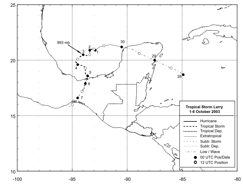
Figure 1:
Best track positions for
Tropical Storm Larry, 1-6 October 2003.
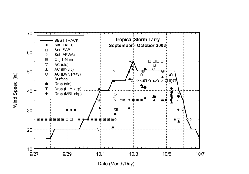
Figure 2:
Selected wind
observations and best track maximum
sustained surface wind speed curve for Tropical Storm Larry, 1-6
October 2003. Aircraft observations have
been adjusted for elevation using an 80% reduction factor for
observations from both 850 mb and 1500 ft. Dropwindsonde
observations include actual 10 m winds (sfc), as well as surface
estimates derived from the mean wind over the lowest 150 m of the
wind sounding (LLM), and from the sounding boundary layer mean
(MBL).Estimates during the remnant low
stage are based on analyses from the National Hurricane Center and
the Tropical Analysis and Forecast Branch. Landfall is indicated by
the vertical line.
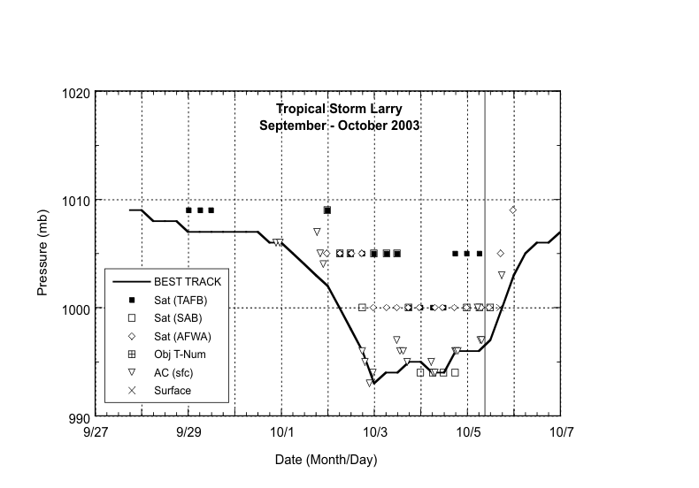
Figure 3:
Selected pressure
observations and best track minimum
central pressure curve for Tropical Storm
Larry, 1-6 October 2003.Landfall is indicated by
the vertical line.
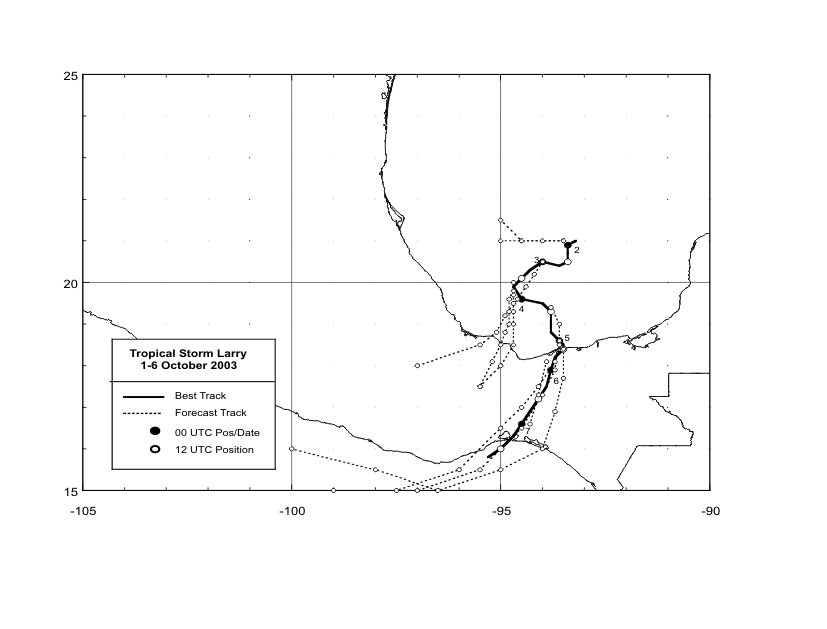
Figure 4:
Selected official track
forecasts (in 12h intervals and indicated by the dashed lines, with
0, 12, 24, 36 ,48, and 72 h positions indicated) for Tropical Storm
Larry, 1-6 October 2003.The best track is given by
the thick solid line with positions given at 6 h
intervals.
|


