Tropical Storm Harvey, which formed in the eastern Gulf of Mexico and moved
across southern Florida, produced heavy rainfall over portions of southwest
Florida.
a. Synoptic History
The tropical wave that produced Harvey moved off the west coast of Africa
late on 4 September with little fanfare. From the 4th through the
14th, the wave's trek across the tropical Atlantic into the
eastern Caribbean Sea was uneventful. This was due, in part, to the
disruptive effects of the upper-level outflow from Hurricane Floyd. By 16
September, with the influence of Floyd's circulation abating, convective
activity in association with the wave began to increase over the western
Caribbean Sea and a broad area of low pressure formed. Upper-air
observations from the northwest Caribbean showed an associated mid-level
circulation near the Cayman Islands. The system drifted northwestward during
the next two days and by the morning of the 18th, the broad area
of low pressure was over the south central Gulf of Mexico. Early on the
19th, satellite imagery showed increasing deep convection near and
east of the broad surface circulation center. This, coupled with a sustained
30 knot wind report from the National Data Buoy Center (NDBC) buoy
42003, located in the eastern Gulf of Mexico, is
the basis for initiating Tropical Depression Ten at 0600 UTC 19 September,
at which time the circulation center was located about 350 n mi
west-southwest of St. Petersburg, Florida as shown in the post-storm "best
track" in Table 1 and Figure 1.
Upper-tropospheric outflow improved over the depression throughout the
19th, indicative of gradual strengthening . Surface observations
and reconnaissance data from the U.S. Air Force Reserve "Hurricane Hunters"
(USAFR) indicated that by 0000 UTC 20 September surface winds were near 40
knots and the system became Tropical Storm Harvey, while located about 300 n
mi west-southwest of St. Petersburg, Florida. Over the next 24 hours,
Harvey's central pressure dropped a modest 7 mb and the storm is estimated
to have reached a peak intensity of 50 knots from 1800 UTC 20 September to
1800 UTC 21 September. Satellite images showed that the system did not
become better organized during this period because of westerly vertical wind
shear. Data from the NOAA G-IV synoptic flow mission over the Gulf of Mexico
on the afternoon of the 20th showed 25 to 35 knot westerly
upper-level winds over the cyclone. This resulted in the displacement of
Harvey's center to the northwest edge of the deep convection along with
restricted outflow over the western semicircle. Satellite imagery also
suggested that dry air was being entrained into the circulation from the
northwest.
After turning from a north to a northeast heading on the afternoon of the
19th, Harvey moved slowly eastward on the 20th. By early on the
21st, the system turned southeast and the forward speed increased
to 9 knots in response to mid-level northwesterly flow depicted in NOAA G-IV
synoptic flow data. Harvey's track bent back to the east by mid morning of
the 21st and the cyclone accelerated in advance of a mid-latitude trough
approaching from the west. Harvey made landfall near Everglades City,
Florida around 1700 UTC 21 September with maximum sustained winds of 50
knots and a minimum central pressure of 999 mb. Later that afternoon, the
center of Harvey became elongated while becoming absorbed by a developing
extratropical cyclone located just off the coast of South Carolina with an
associated front extending into south Florida. Harvey lost its identity over
the western Atlantic early on the 22nd as it merged with the
extratropical cyclone.
b. Meteorological Statistics
The best-track curves of minimum central sea-level pressure and maximum
sustained one-minute average "surface" (10 meters above ground level) wind
speed are shown in Figure 2a.
This figure also contains the data upon which
the curves are based: USAFR reconnaissance data, satellite-based
Dvorak-technique intensity estimates from the Tropical Analysis and Forecast
Branch (TAFB), the Satellite Analysis Branch (SAB), and the U.S. Air Force
Weather Agency (AFGWC in the figures).
1. Wind and Pressure Data
The USAFR Hurricane Hunters flew five reconnaissance missions into Harvey
and made 14 center fixes. The highest wind speed reported in Harvey was 58
knots, at 1500 feet, at 1554 UTC 21 September; the lowest central pressure
was 994 mb at 0813 UTC 21 September.The maximum sustained wind of 50 knots
at 1800 UTC 20 September was based on an observation of 47 knots from ship
WCOB; The C-MAN buoy at Molasses
Reef (MLRF1) recorded a maximum wind of 47 knots,
with a gust to 59 knots, at 1743 UTC 21 September while Fowey Rocks Light
(FWYF1) reported 45 knots sustained winds, with
a gust to 51 knots at 1800 UTC, and the aircraft data, all support the
continuation of the 50-knot maximum sustained wind speed in the best track
through 1800 UTC 21 September. These reports, along with other buoys and
ship reports of 34 knot winds or higher, are listed in
Table 2.
Table 3 lists a selection of surface observations
from land stations. The highest official sustained surface wind observed
over land was 32 knots at the Key West Airport at 1956 UTC 21 September.
The Turkey Point Nuclear Power Plant recorded a 10-minute 46 knot wind, at a
9 meter elevation, at 1610 UTC 21 September while the highest gust, 48
knots, was recorded at Tenraw in the Everglades in Dade County (25.6N/81.9W)
at 1700 UTC. The lowest pressure observed in south Florida was 999.4 mb at
the Fort Lauderdale Airport at 1953 UTC 21 September.
A Carnival Cruise Line vessel provided two observations on
20 September of tropical storm-force winds. These reports were used to help
define the tropical storm-force wind and the 12-foot sea radii.
2. Rainfall Data
The highest storm-total rainfall recorded in Harvey was 10.03 inches at the
Naples Conservancy in Collier County. Naples Lakewood measured 10 inches of
rainfall while Naples/Collier County Emergency Management estimated
a similar amount at their operations center. These measurements are
consistent with NWS doppler radar estimates. Substantial street flooding was
reported in the Naples area. Street flooding was also reported in portions
of Lee County, with two homes flooded in Bonita Springs. Rainfall totals of
5.53 and 6.72 inches were observed at Immokalee and Everglades City,
respectively. Storm total rainfall across Miami-Dade, Broward, and Palm
Beach counties ranged from 0.75 inches (West Palm Beach Airport) to 2.85
inches (Coral Springs).
3. Storm Surge Data
The maximum recorded storm surge was 2.41 feet at Fort Myers with estimates
of 2 to 3 feet common elsewhere in Charlotte County. Storm surge values
ranged from 1 to 2 feet elsewhere in southwest Florida and in the Florida
Keys. Tidal flooding was reported in Everglades City including the county
airport where a portion of the runway was flooded resulting in the closure
of the airport. Minor coastal flooding was also reported along the
south-facing portions of the Florida Keys and the west-facing shores of
Florida Bay. Sections of Highway A1A in the Keys were closed due to the
flooding. The combined effect of wave action and the storm surge resulted
in minor beach erosion in Sarasota County, along the south-facing shores of
the Keys, and in the back country of Everglades National Park.
4. Tornadoes
Harvey resulted in two confirmed tornadoes. One tornado, an F0, touched down
briefly in Collier County near Paradise Point taking the roof off one house,
while the other touched down in Dade County with no reported damage.
c. Casualty and Damage Statistics
No reports of casualties due to Harvey have been received at the National
Hurricane Center.
Property damage estimates supplied by the Property Claims Services Division
of the American Insurance Services Group indicate that Harvey caused about
$7.5 million in insured losses in southern Florida. This estimate excludes
storm surge damage. To determine the total estimated damage, a ratio of 2:1
is applied to the insured property damage; this is based on comparisons done
in historical hurricanes. Thus, the total estimated damage from Harvey is
$15 million.
d. Forecast and Warning Critique
The incipient disturbance that was to become Harvey was first identified as
a candidate for development in NHC's Tropical Weather Outlook about two and
a half days before it became a tropical depression.
There were only nine forecasts issued while Harvey was a tropical storm with
only one verifying at 48 hours and none at 72 hours. This number of cases is
too small to obtain a meaningful quantitative evaluation of forecast
accuracy. However, Harvey was forecast to move across central Florida by
most of the computer guidance as well as the official forecasts, and instead
moved through south Florida.
Table 4 lists the various watches and warnings
that were issued for Harvey.
The formation of Harvey in the eastern Gulf of Mexico prompted the issuance
of a tropical storm watch for the west coast of Florida, from the mouth of
the Swannee River to Bonita Beach, with the first advisory. A tropical
storm warning and a hurricane watch were issued six hours later with the
warning extended southward to east Cape Sable at 2100 UTC 20 September. This
was 20 hours prior to Harvey's landfall in southwest Florida near
Everglades City. By early on the 21st, Harvey turned southeast
and the forward speed increased, necessitating the extension of tropical
storm warnings at 0900 UTC 21 September from Cape Sable to Boca Raton,
including the Florida Keys.
Acknowledgements
Some of the data in this report was provided by the National Weather Service
Forecast Offices in Tampa, Melbourne, Key West, and Miami . James Franklin
produced the wind and pressure plots.

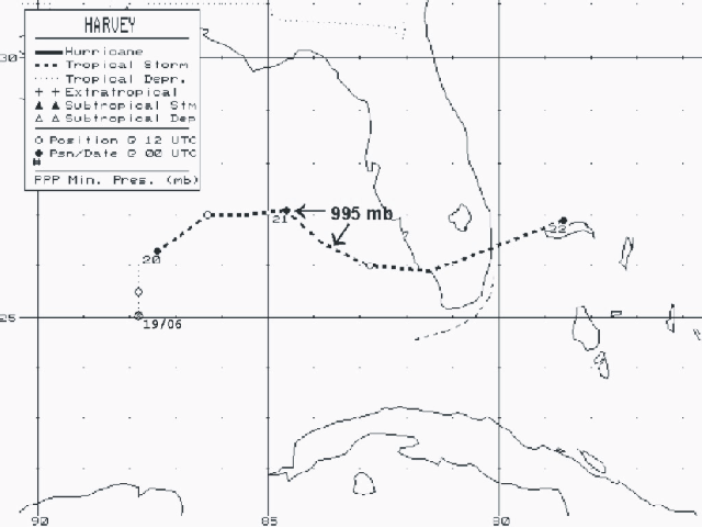
Figure 1. Best track positions for Tropical Storm Harvey, 19-21 September 1999.

Figure 2a.
Best track minimum central pressure curve for Tropical Storm Harvey, 19-22
September 1999.

Figure 2b. Best track maximum sustained 1-minute 10 meter wind
speed curve for Tropical Storm Harvey, 19 - 22 September 1999.
Table 1. Preliminary Best Track - Tropical Storm Harvey, 19 - 21 September 1999.
Date/Time
(UTC) |
Position |
Pressure
(mb) |
Wind Speed
(kt) |
Stage |
| Lat. (°N) | Lon. (°W) |
| 19/0600 | 25.0 | 87.8 | 1005 | 30 | Tropical Depression |
| 19/1200 | 25.5 | 87.8 | 1004 | 30 | " |
| 19/1800 | 26.0 | 87.8 | 1003 | 30 | " |
| 20/0000 | 26.3 | 87.4 | 1002 | 40 | Tropical Storm |
| 20/0600 | 26.6 | 86.9 | 1001 | 40 | " |
| 20/1200 | 27.0 | 86.3 | 998 | 40 | " |
| 20/1800 | 27.0 | 85.5 | 998 | 50 | " |
| 21/0000 | 27.1 | 84.6 | 995 | 50 | " |
| 21/0600 | 26.5 | 83.9 | 995 | 50 | " |
| 21/1200 | 26.0 | 82.8 | 996 | 50 | " |
| 21/1800 | 25.9 | 81.5 | 999 | 50 | " |
| 22/0000 | 26.9 | 78.6 | 1000 | 40 | " |
| 22/0600 | | Merged with Low |
| |
| 21/0800 | 26.3 | 83.7 | 994 | 50 | Minimum Pressure |
| 21/1700 | 25.9 | 81.7 | 999 | 50 | Landfall near Everglades City, FL |
Table 2.
Tropical Storm Harvey selected National Buoy Data Center (NBDC) and ship
observations, September 1999.
| |
Minimum
sea-level
pressure |
Maximum surface wind speed
(kt) |
|
| Location |
Pressure
(mb) |
Date/time
(UTC) |
Sustained
winda
(kts) |
Peak
gust (kts) |
Date/timeb
(UTC) |
Significant
Wave Height
(ft) |
| CMAN Stations |
| Lake Worth, FL (LKWF1) | 1010.0 | 25/1100 | 30 | 35 | 25/1400 | |
| Fowey Rocks, FL (FWYF1) | | | 45 | 51 | 21/1800 | |
| Molasses Reef, FL ( MLRF1) | 1001.5 | 21/1800 | 47 | 59 | 21/1743 | |
| Long Key, FL (LONF1) | 1003.1 | 21/1800 | 28 | 40 | 21/1200 | |
| Sombrero Key, FL (SMKF1) | | 21/1600 | 36 | 41 | 21/1400 | |
| Sand Key, FL (SANF1) | 1002.9 | 21/1700 | 35 | 40 | 21/1305 | |
| Dry Tortugas, FL (DRYF1) | | | 25 | 31 | 21/1200 | |
| NBDC Buoys |
| 42003 (25.9N / 89.9W) | 1001.6 | 20/2200 | 34 | 42 | 20/0400 | |
| 42036 (28.5N / 84.5W) | 1003.5 | 20/2200 | 26 | 32 | 20/1800 | |
| 34-Knot Ship Reports |
| WCPU (25.6N / 86.7W) | 1004.0 | 19/2300 | 40 | | 19/2300 | 23.0 |
| PFFV (25.3N / 85.8W) | 1003.2 | 20/1200 | 40 | | 20/1200 | 16.0 |
| WCHF (25.0N / 84.8W) | 1004.8 | 20/1500 | 40 | | 20/1500 | 15.0 |
| WCOB (25.7N / 85.2W) | 1003.0 | 20/1800 | 47 | | 20/1800 | 18.0 |
| Carnival Cruise Line (26.2N/83.6W) | | 20/2200 | 40 | | | 12.0 |
| Carnival Cruise Line (26.0N/83.3W) | | 21/0000 | 35 | | | 10.0 |
| ELXB9 (24.3N / 83.2W) | 1007.0 | 21/0000 | 35 | | | |
| ELBM9 (25.7N / 83.6W) | | 21/0600 | 40 | | 21/0600 | |
| WCOB (25.5N / 79.7W) | 1000.5 | 21/1800 | 45 | | 21/1800 | 16.4 |
aStandard NWS C-MAN averaging period is 2 min; buoys are 8 min.
bDate/time is for sustained wind when both sustained and gust are listed.
Table 3. Tropical Storm Harvey selected surface observations, September 1999.
| |
Minimum
sea-level
pressure |
Maximum surface wind speed
(kt) |
|
| Location |
Pressure
(mb) |
Date/time
(UTC) |
Sustained
winda
(kts) |
Peak
gust (kts) |
Date/timeb
(UTC) |
Storm
surgec
(ft) |
Storm
tided
(ft) |
Rain
(storm total)
(in) |
| Florida | | | | | | | | |
| Key West Airport | 1004.1 | 21/1956 | 32 | 37 | 21/1404 | | | 0.33 |
| Tavernier | | | | | | | | 1.13 |
| Marathon | | | | | | | | 0.04 |
| Key West | | | | | | 0.8 | | |
| Vaca Key | | | | | | 1.0 | | |
| Homestead | | | | | | | | 0.96 |
| Turkey Pt. Nuclear Plant | | | 46* | | 21/1800 | | | |
| Tamiami Aprt (KTMB) | | | 25 | 36 | 21/1909 | | | 1.26 |
| Miami Int. Aprt (KMIA) | | | 23 | 36 | 21/1925 | | | 1.52 |
| NWSFO Miami | 29.6 | 21/1930 | | | | | | |
| Hollywood | | | | | | | | 3.29 |
| Ft. Lauderdale | | | | | | | | 6.62 |
| Ft. Lauderdale Beach | | | | | | | | 3.88 |
| Ft. Lauderdale (KFLL) | 999.4 | 21/1953 | 23 | 33 | 21/1904 | | | 1.87 |
| Ft. Lauderdale (KFXE) | 999.5 | 21/1953 | | | | | | |
| Pompano Beach (KPMP) | 999.5 | 21/1950 | | | | | | |
| W. Palm Beach (KPBI) | | | | | | | | 0.73 |
| Tenraw WIMS (Dade) | | | 28 | 48 | 21/1700 | | | 1.61 |
| Naples/Collier EM | 29.6 | 21/1445 | | 34 | 21/XXXX | | | 10.00 |
| Immokalee (Collier) | | | | | | | | 5.53 |
| Everglades City (Collier) | | | | | | | | 6.72 |
| Naples Conserv (Collier) | | | | | | | | 10.03 |
| Naples Lkwd (Collier) | | | | | | | | 10.00 |
| Ochopee WIMS (Collier) | | | | | | | | 2.06 |
| Coral Springs (Broward) | | | | | | | | 2.85 |
| Sarsota Aprt (KSRQ) | 1003.1 | 21/1053 | 25 | 31 | 21/0410 | | | 1.80 |
| Sunshine Skywy (Hillsb) | | | | 31 | 21/0006 | | | |
| Venice Dardc (Sarsota) | | | 21 | | 21/2000 | | | |
| St Petersburg (KPIE) | 1003.1 | 21/1053 | 14 | 19 | 21/0117 | | | |
| Tampa Arpt (KTPA) | 1004.5 | 21/0956 | 11 | 17 | 20/0320 | | 1.79 | |
| Fort Myers (KFMY) | 1004.0 | 21/1053 | 14 | 20 | 21/0853 | | 2.41 | |
| Levy County | | | | | | | 1-2 | |
| Citrus County | | | | | | | 1-2 | |
| Hernando County | | | | | | | 1-2 | |
| Pasco County | | | | | | | 1-2 | |
| Pinellas County | | | | | | | 1-2 | |
| Hillsborough County | | | | | | | 1-2 | |
| Manatee County | | | | | | | 1-2 | |
| Sarasota County | | | | | | | 1-2 | |
| Charlotte County | | | | | | | 2-3 | |
bDate/time is for sustained wind when both sustained and gust are listed.
cStorm surge is water height above normal astronomical tide level.
dStorm tide is water height above NGVD.
eEstimated.
*10 minute/9 meter wind
XXXX - time unknown
Table 4. Watch and warning summary, Tropical Storm Harvey, September 1999.
Date/Time
(UTC) |
Action |
Location |
| 19/0300 | Tropical Storm Watch Issued | Florida West Coast: Bonita Beach Florida to the mouth of the Suwannee River |
| 20/1500 | Tropical Storm Warning and Hurricane Watch Issued | Florida West Coast: Bonita Beach Florida to the mouth of the Suwannee River |
| 20/1500 | Tropical Storm Watch Issued | Florida East Coast: North of Jupiter Inlet to just south of Flagler Beach...including Lake Okeechobee |
| 20/2100 | Tropical Storm Warning Extended | Florida West Coast: East Cape Sable to the mouth of the Suwannee River |
| 20/2100 | Tropical Storm Watch Extended | Florida East Coast: Florida City to just south of Flagler Beach... including Lake Okeechobee |
| 21/0000 | Tropical Storm Watch Issued | Northwest Bahamas: Grand Bahama Island and the Abacos |
| 21/0300 | Tropical Storm Warning Extended | Florida East Coast: south of Flagler Beach to Boca Raton... including Lake Okeechobee |
| 21/0900 | Tropical Storm Warning Issued | Northwest Bahamas: Grand Bahama Island and the Abacos |
| 21/0900 | Tropical Storm Warning Extended | Boca Raton to East Cape Sable including the Florida Keys... the Dry Tortugas... Florida Bay and the Florida Straits |
| 21/0900 | Tropical Storm Warning Discontinued | Florida East Coast: North of Sebastian Inlet
Florida West Coast: North of Longboat Key |
| 21/0900 | Hurricane Watch Discontinued | Florida West Coast: Bonita Beach to the mouth of the Suwannee River |
| 21/1500 | Tropical Storm Warning Discontinued | Florida East Coast: North of Jupiter Inlet to just south of Flagler Beach ...including Lake Okeechobee
Florida West Coast: Bonita Beach to the mouth of the Suwannee River |
| 21/2100 | Tropical Storm Warning Discontinued | South of Bonita beach southward through the Florida Keys to just west of Craig Key...including the Dry Tortugas |
| 22/0000 | Tropical Storm Warning Discontinued | Florida East Coast: Craig Key to Jupiter Inlet...including Florida bay and the Florida Straits |
| 22/0300 | Tropical Storm Warning Discontinued | Northwest Bahamas: Grand Bahama Island and the Abacos |
![[NCEP Logo]](graphics/ncep.gif)