The inland wind model was developed by Mark DeMaria (NOAA/NWS/TPC) and John Kaplan (NOAA/AOML/HRD). The model applies a simple two parameter decay equation to the hurricane wind field at landfall to estimate the maximum sustained surface wind as a storm moves inland. This model can be used for operational forecasting of the maximum winds of landfalling tropical cyclones. It can also be used to estimate the maximum inland penetration of hurricane force winds (or any wind threshold) for a given initial storm intensity and forward storm motion. For further explanation refer to:
Kaplan, J., DeMaria, M., 1995: A Simple Empirical Model for Predicting the Decay of Tropical Cyclone Winds After Landfall. J. App. Meteor., 34, No. 11, 2499-2512.
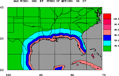
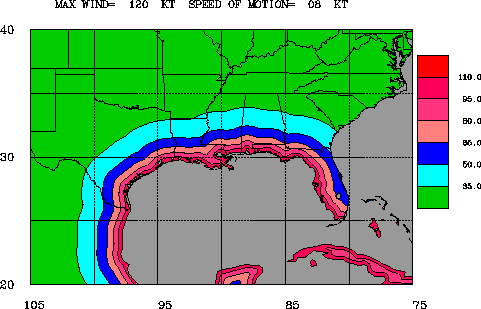
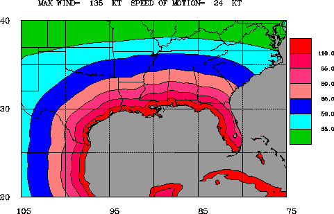
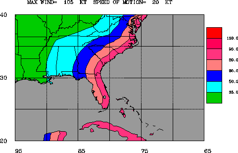
The tables below will allow you to display examples of the Maximum Envelope Of Winds (MEOW). Three tables are shown, one for each of the regions: Gulf coast, East coast, and Northeast Coast. Click on the word GIF to display the MEOW for a specific hurricane strength (as measured by the Saffir-Simpson Hurricane Scale) and forward motion of a typical hurricane.
NOTE: The MEOW references in this document do not pertain to the hurricane storm surge term "MEOW" - which refers to the "Maximum Envelope of Water".
| Strength | Forward Motion (knots) | ||||
|---|---|---|---|---|---|
| Category 1 | 8 | 12 | 16 | 20 | 24 |
| Category 2 | 8 | 12 | 16 | 20 | 24 |
| Category 3 | 8 | 12 | 16 | 20 | 24 |
| Category 4 | 8 | 12 | 16 | 20 | 24 |
| Category 5 | 8 | 12 | 16 | 20 | 24 |
| Strength | Forward Motion (knots) | ||||
|---|---|---|---|---|---|
| Category 1 | 8 | 12 | 16 | 20 | 24 |
| Category 2 | 8 | 12 | 16 | 20 | 24 |
| Category 3 | 8 | 12 | 16 | 20 | 24 |
| Category 4 | 8 | 12 | 16 | 20 | 24 |
| Category 5 | 8 | 12 | 16 | 20 | 24 |
| Strength | Forward Motion (knots) | ||
|---|---|---|---|
| Category 1 | 15 | 25 | 35 |
| Category 2 | 15 | 25 | 35 |
| Category 3 | 15 | 25 | 35 |
Get Storm Info
Satellite Imagery -
US Weather Radar -
Aircraft Recon -
Advisory Archive -
Mobile Products -
E-Mail Advisories -
RSS Feeds -
About NHC Products
Tropical Analysis and Forecasting
Atlantic Products -
E Pac Products -
About TAFB Products
Learn About Hurricanes
Hurricane Awareness -
Frequently Asked Questions -
AOML Hurricane-Research Division -
Hurricane Hunters -
The Saffir-Simpson-Hurricane Scale -
Forecasting Models -
Inland Wind Model -
Eyewall Wind-Profiles -
TPC Glossary -
TPC Acronyms -
Storm Names
Breakpoints
Hurricane History
NHC/TPC Archives -
Forecast Verification -
Climatology -
1492-1996 (Atlantic) -
1900-2000 (USA) -
Most Expensive -
Most Intense -
US Strikes by Decade -
US Strikes by State
About Us
About the TPC -
Mission/Vision -
Other NCEP Centers -
TPC Personnel -
NOAA Locator -
Visitor Information -
NHC Library -
WX4NHC Amateur Radio Station
NOAA/
National Weather Service
National Centers for Environmental Prediction
National Hurricane Center
Tropical Prediction Center
11691 SW 17th Street
Miami, Florida, 33165-2149 USA
nhcwebmaster@noaa.gov
Disclaimer
Privacy Policy
Credits
About Us
Glossary
Career Opportunities
Page last modified: Wednesday, 28-Jun-2006 18:55:19 GMT