SEVERE DOWNSLOPE WIND STORMS
A Primer and Case Study of the February
3, 1998 Gabbs, Nevada Event
Kim Runk
1.
INTRODUCTION
During the Winter and Spring months,
windy days occur fairly regularly in Nevada,
and indeed across the entire Great Basin. Prolonged periods of strong, gusty wind in
our area are typically caused by some combination of concentrated pressure
gradient force and gap flow. But
occasionally conditions favor a more uncommon and very damaging windstorm that
can be characterized as a mountain wave event.
Such was the case in the central Nevada
mining town of Gabbs
(Fig.1) on February 3, 1998.
 (Click
on thumbnail to view full size image)
(Click
on thumbnail to view full size image)
Fig. 1 – Topographic map of west central Nevada. The mining town of Gabbs is on the
northwest slopes of the
Paradise Range, and is located approximately 90 miles
southeast of Reno.
A downslope windstorm occurred
early that morning along the western side of the Paradise Range,
producing sustained winds estimated at 70-80 mph with gusts approaching 100 mph
in Gabbs.
Several mobile homes were either overturned or blown off their moorings,
numerous mature trees were completely uprooted, and there was widespread structural
damage to small buildings around the mining facility (Fig.
2). Most of the community was
awakened from sleep by the storm as the strongest winds occurred between the
hours of 3:00-6:00 a.m. PST. Residents
reported they had never encountered wind of that intensity before, describing
the experience as frightening.
 (Click
on thumbnail to view full size image)
(Click
on thumbnail to view full size image)
Fig. 2 – Damage photos in Gabbs
the morning after a 100-mph downslope wind event in
February 1998.
This case study will document the windstorm as it appeared
in analyses and forecast products centered around 1200 UTC, February 3, 1998,
highlighting the most significant aspects of attempting to forecast such an
event. It is important to note that the
available NCEP model guidance was unable to resolve several crucial details
surrounding this event=s
development, primarily owing to three deficiencies:
(1)
the
highest horizontal resolution of any operational numerical guidance at the time
was the 32-km Eta; a grid spacing that is generally
too coarse to resolve the most useful and identifiable forecast parameters;
(2)
the
operational Eta is a hydrostatic model, and some of
the most important processes involved in generating downslope
windstorms are non-hydrostatic.
(1)
the Eta
step coordinate has been shown to be ineffective at generating mountain wave
features, even when run experimentally at very high resolution.
These shortcomings notwithstanding, it is hoped that this
discussion will provide sufficient background information that can be used to infer
the presence or development of the key precursors when confronting similar
situations in the future. In order to
gain insight into the processes surrounding the storm=s
development, a high-resolution modeling simulation was conducted after the
fact, using a non-hydrostatic, two-way interactive nest configuration of RAMS
at 4-km horizontal grid spacing on the inner nest (Fig.
3). Output from this simulation
will be used to complement the Eta guidance in order
to identify and explain the most important forecast parameters for severe
mountain wave-type downslope windstorms.
 (Click
on thumbnail to view full size image)
(Click
on thumbnail to view full size image)
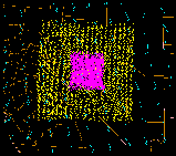
Fig. 3 – Plan view depiction of double nest configuration
for RAMS simulation of Gabbs wind event.
Horizontal grid spacing for innermost nest is 4 km. Outer
nest is 12 km. Initialization and boundary
conditions were input from the
29-km MesoEta.
1.
KEY CONCEPTS
OF DOWNSLOPE WINDSTORMS
Downslope windstorms have been the
topic of numerous studies, ranging from dynamical assessments (e.g., Klemp and Lilly, 1975; Smith, 1985) to detailed
investigations of specific cases (e.g., Mass and Albright, 1985; Neiman et al.,
1988). From a forecaster=s perspective, one of the most
practical references published in recent years was a two-part paper by Colle and Mass (1998), studying windstorms along the slopes
of the Washington Cascades. In this
study, the authors identified four significant factors associated with the
development of major downslope wind events:
(1) Strength of the cross‑barrier flow
(2) Magnitude of the cross‑barrier
pressure gradient (measured as MSLP)
(3) Presence of a critical level
(4) A stable layer near ridge crest with
lower stability above
All four factors were evident in the strongest downslope wind events, although the first two factors
accounted for a significant amount of variance in the strength of observed
winds. For situations characterized by
strong cross-barrier flow, the presence of a critical level was found to be
crucial to the development of mountain wave-type storms. However, it was noted that wave formation
results in warming of the column and lowers the surface pressure in the lee of
the mountains, which increases the cross‑barrier pressure gradient. So, a
wave‑type event can actually induce stronger gap flow.
Since the presence of a so-called Acritical
level@ has been
identified as a fundamental factor for mountain wave development, it=s important to understand what it
is. When strong flow encounters a
topographic barrier, a vertically propagating gravity wave is generated. Sometimes this energy is simply dispersed as
turbulence. But sometimes the gravity
wave is prevented from continuing its ascent and expansion, and the energy is
deflected and redirected toward the surface.
A critical level (or more accurately, a critical layer) is the region in
the atmosphere that prevents the gravity wave energy from continuing
upward. This is key
to mountain‑wave formation. This
process of redirecting packets of concentrated wave energy downward is why it
is possible to produce surface wind speeds at the base of the mountains far
exceeding wind speeds observed at any level in the free atmosphere.
If a critical level exists in the synoptic scale observed or
forecast data, it is said to be a Amean-state@ critical level. A mean‑state critical level is
typically defined as a point in the atmosphere where the cross‑barrier
flow goes to zero. This can be a place
where the winds become very light, or where the winds become parallel to the
barrier. In ideal situations, it occurs
in a region where a wind direction reversal takes place in the vertical (e.g.,
going from easterly to westerly flow).
Another important aspect of a critical level is that it is
found within a layer of relatively unstable air aloft which is superimposed on
a stable layer located near the ridge-crest.
A fluid oscillation can take place in the stable layer, but not in the
unstable layer, so the energy from the oscillation (a gravity wave) cannot propagate
upward. An idealized diagram of this
configuration is shown in Figure 4.
 (Click
on thumbnail to view full size image)
(Click
on thumbnail to view full size image)
Fig. 4 – Idealized cross section diagram of a downslope wind event on the western slopes of a north-south
oriented mountain
range (view is to the north).
Vertical scale is pressure in mb. Black lines are isentropes. Shaded areas represent relative
wind speed (e.g., red > 75kts,
blue > 55 kts, green > 35 kts).
Wave breaking seems to be enhanced in the presence of a
cross‑barrier flow that decreases with height, also known as Areverse shear@. It is thought that reverse shear can lead to
wave breaking even in the absence of a mean‑state critical level. Such a structure can be visualized as the
turbulence generated by a breaking ocean wave.
As the wave crests and breaks, a region of turbulence is created where
the flow may either reverse or go to zero.
This region acts to prevent energy from propagating through it. This specialized type of critical level is
referred to as a Aself-induced@ critical level. It can be generated by the mountain wave
circulation itself and occurs on a much smaller scale than the mean-state
type. In fact, a self-induced critical
level can only be observed with a high-resolution network of equipment such as
that which is available in a field experiment.
A closer look at the Gabbs example
should help to clarify these concepts.
2.
SYNOPTIC
SETTING
Unfortunately it=s
difficult to assess the actual local flow conditions at analysis time since the
area of interest is well out of radar range, and a considerable distance from
the nearest radiosonde site. In addition, there are no automated
observation platforms near Gabbs, nor were there any
trained weather observers in the area.
Thus much of what occurred has to be inferred from the model forecast
data, making the assumption that it is a reasonable representation of what
really happened. This is not the best
method for evaluating an event such as this, but in this case there are some
useful insights to be gained by starting with this premise.
A deep trough was moving toward the Pacific coast with a
vertically stacked closed low forecast to form about 150 miles west of Eureka by 1200 UTC, 03
February 1998 (Fig. 5). Jet level energy was lifting out of the base
of the trough with strong southwest flow aloft spreading across Nevada. Pressure tendencies seen in the METAR
observations, and captured by the RUC Surface Analysis, showed pressure rises
in eastern Utah and northeast Arizona, while pressure falls were occurring over
western Nevada and eastern California (Fig. 6). A three-hour fall maximum was located over
Pershing County in western Nevada. The
prevailing low level wind was directed from southeast to northwest, and the mean
sea level pressure gradient was forecast to strengthen across Nevada to around
12-15mb from LAS-RNO by 1200 UTC. A
region of strong dynamic ascent was forecast in the 700-500mb layer over
central California
along and west of the Sierra (Fig. 7). A weaker wave lifting out of the mean trough
position was forecast to generate a modest up-down couplet of forcing for
vertical motion in northwestern Nye
County near the area of
interest with an accompanying cross-barrier flow of 25-30 knots at 850mb and
about 45 knots at 700mb.
 (Click
on thumbnail to view full size image)
(Click
on thumbnail to view full size image)
Fig. 5 – Eta 12h 500mb height/vorticity forecast, valid 1200 UTC, February 3, 1998.
 (Click
on thumbnail to view full size image)
(Click
on thumbnail to view full size image)
Fig. 6 – RUC surface pressure and 3h change analysis, valid
1100 UTC, February 3, 1998.
 (Click
on thumbnail to view full size image)
(Click
on thumbnail to view full size image)
Fig. 7 – Eta 700-500mb
omega forecast, valid 1200 UTC, February 3, 1998.
A northwest-to-southeast MesoEta
cross-section between Fallon (NFL) and Tonopah (TPH) is depicted in Figure 8. While
there is a significant cross-barrier flow in the lower levels, and some
suggestion of an unstable mid-tropospheric layer (as
evidenced by a relatively large separation in the isentropes)
above a marginally stable mountain-top layer, it does not reveal any compelling
evidence that points to the presence of a mean-state critical level for
mountain wave development. The unusually
strong sea‑level pressure gradient was sufficient to raise concerns for
the likelihood of wind advisory criteria being exceeded, but the potential for
a major mountain wave event was not recognized.
 (Click
on thumbnail to view full size image)
(Click
on thumbnail to view full size image)
Fig. 8 – Eta
cross section of isentropes and winds from Fallon NAS, NV (NFL) to Tonopah, NV
(TPH), valid 1200 UTC, February 3, 1998. Gabbs
is approximately half way between the two end points.
3.
MESOSCALE
SIMULATION
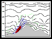
A similar cross-section from the high-resolution RAMS
simulation (Fig. 9) reveals a more detailed
structure that might have provided needed clues for the forecaster to be wary
of an impending mountain wave event. The
layer of moderately unstable air between about 550-300mb is comparable to the
one shown by the MesoEta, but the stable layer
beneath it (which tops out just above ridge-crest level) is slightly more
pronounced in the RAMS output. There is
no flow reversal per se, but there is a well-defined windspeed
minimum accompanied by a deep wave in the isentropes
directly above Gabbs.
This region of relatively light mid-tropospheric
winds coincides with the point where the mean wind became parallel to the
central Nevada mountain ranges. As a
result, winds tangential to the plane of the cross-section diminished to less
than 20 knots at 350mb. This region of
low-speed winds embedded in an unstable layer represents the critical
level. This feature
along with the accompanying deep wave in the isentropes
are important indicators of mountain wave formation. Because RAMS was able to resolve these key
features, it developed a much stronger low-level wind over the area of
interest, indicating a sustained wind of 38 ms-1
(~80 knots) in the Gabbs area (Fig.
10).
 (Click
on thumbnail to view full size image)
(Click
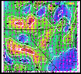
on thumbnail to view full size image)
Fig. 9 – RAMS cross section (inverted from Fig 8), depicting
isentropes (black) and wind speeds (shaded with white
contour lines). Note improved resolution of stable layer near mountain tops,
presence of a critical layer centered near 360mb, and defined wave action in isentropes with accompanying descent of high speed winds.
 (Click
on thumbnail to view full size image)
(Click
on thumbnail to view full size image)
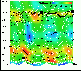
Fig. 10 –
Plan view of RAMS 4 km wind forecast, valid 1200 UTC, February 3,
1998. Grid point nearest Gabbs
suggests wind speeds in the 70-75 kt range.
In eastern California and
extreme southern Nevada, these conditions
would manifest themselves in a strong upper tropospheric
westerly flow against the Sierra or the Spring Mountains. Such a case occurred in the Mt Charleston
area on November 18, 1998 when an unusually strong wind was reported by both
the Nevada Division of Forestry at Mt Charleston and by the U.S. Forest Service
at Red Rock Canyon. The cross-section
from a 10km RAMS simulation (Fig. 11) indicates a
stable layer from surface to mountain-top beneath a more unstable layer with
up-down couplets and a wind reversal (east near the surface to west-southwest
aloft). In this case, the strong winds
were localized to the lee of the Spring Range, with reports suggesting about
60-70 mph sustained, much higher than the gradient would support. Localized high wind events are undoubtedly
far more common along the eastern Sierra slopes, but lack of observational data
makes it difficult to verify, or even build a climatology
of key antecedent conditions based on actual cases.
 (Click
on thumbnail to view full size image)
(Click
on thumbnail to view full size image)
Fig. 11 – Cross section of Spring Mountains
from operational 10 km RAMS simulation, valid 0000 UTC, November 12, 1998. Winds reversed from easterly near the surface
to westerly aloft through a mountain top stable layer. Wave action was suggested in advance by isentropes and vertical velocity signatures. Sustained winds along the lee slopes of Mt
Charleston exceeded 60 kts.
4.
CONCLUSION
Despite these limitations, it is possible to identify and
predict significant downslope wind events in remote
areas, given an understanding of the physical mechanisms that generate such
events. The conditions outlined and
illustrated here should provide forecasters the basic tools to assess similar
events in the future.
*********************
BIBLIOGRAPHY
Colle, B.A., and C.F. Mass, 1998:
Windstorms along the western side of the Washington
Cascades. Part I: A high resolution observational and
modeling study of the 12 February 1995 event.
Mon. Wea Rev., 126, 28-52.
Colle, B.A., and C.F. Mass, 1998: Windstorms along the
western side of the Washington Cascades.
Part II: Characteristics of past events and three-dimensional idealized
simulations. Mon. Wea
Rev., 126, 53-71.
Klemp, J.B., and D.K. Lilly, 1975: The dynamics of wave
induced downslope windstorms.
J. Atmos.
Sci., 32, 320-339.
Mass, C.F., and
M.D. Albright, 1985: A severe windstorm in the lee of the Cascade mountains of Washington state. Mon. Wea Rev., 113, 1261-1281.
Neiman, P.J.,
R.M. Hardesty, M.A. Shapiro, and R.E. Cupp, 1988:
Doppler lidar observations of a downslope
windstorm. Mon. Wea.
Rev., 116, 2265-2275.
Smith, R.B., 1985: On severe downslope
winds. J. Atmos.
Sci., 42, 2597-2603.
 (Click
on thumbnail to view full size image)
(Click
on thumbnail to view full size image) (Click
on thumbnail to view full size image)
(Click
on thumbnail to view full size image) (Click
on thumbnail to view full size image)
(Click
on thumbnail to view full size image)


