
Overview
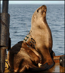
The National Marine Mammal Laboratory (NMML) Alaska Ecosystem Program uses satellite telemetry to collect information on Steller sea lion foraging ecology. NMML began satellite telemetry studies of Steller sea lions in the late 1980s, using this emerging technology to remotely track the movements of individual adult females through the marine environment. Satellite transmitters attached to sea lions provide information on location, dive characteristics, time on land and at sea, and other data. The current focus of our research is on sea lions 6 months old to 2+ years of age whose survival rate is an important component of the decline of Steller sea lions.
The Alaska Ecosystem Program Telemetry Research Pages contain satellite telemetry data from current and previous NMML satellite transmitter deployments on Steller sea lions at research sites throughout Alaska and Washington State. The telemetry research pages include a description of the capture methods and instrumentation, how the data are collected and processed, current and previous deployments, and a user guide to help navigate the site. The Current Deployments page has a map of the northern Pacific showing study areas where NMML deploys satellite transmitters on Steller sea lions. The map corresponding to each area shows Steller sea lion rookeries, haulouts and deployment sites within the regional study area. Underneath the map is a deployment table with links displaying when each capture trip was made and whether any satellite tags are still active and transmitting data. The Animal List table for active deployments shows the tagging location, animal ID, dates of the deployment and the last reception, the quality of the last location, the number of hits received by the satellite on the transmitters last active day, the deployment duration, and when it was last heard from. The archive link shows similar information for sea lions instrumented on previous tagging trips. The "Interactive Map" link connects to an Internet map server where users can display and query tracking data for sea lions instrumented on each tagging trip.