USGS CoreCast
USGS Podcasts Home > CoreCast Home Page
Can't see Flash? Install Flash Player.
|
10
|
In our second Earth Science Week installment, we talk with scientist Richie Williams about the USGS's amazing new satellite imagery of Antarctica as well as what's going on with ice on the southernmost continent.
Type: audio/mpeg
File Size: 4472375 bytes Duration: 4:34 Released: Tue, 16 Oct 2007 10:32:57 UTC |
Transcript:
[music fades in and out]
Steve
Hello and welcome. You're listening to the USGS CoreCast, Earth Science Week daily special. Today is Tuesday, October 16th, 2007. I'm Steve Sobieszczyk.
Yesterday you heard Scott Horvath talk with the USGS Senior Science Advisor Tom Armstrong about the Northwest Passage in the Arctic. Today, we're switching gears and crossing the globe to examine what's up on the bottom, as we discuss the new Landsat Image Mosaic of Antarctica. You could say today is the polar opposite of yesterday. Get it, polar . . . opposite . . . yeah—you know what I'm talking about.
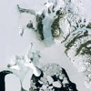
The Landsat Image Mosaic of Antarctica is unique because it is the first seamless, continent-wide, high-resolution imagery available. The imagery will be conveniently located within the new USGS Antarctic Web portal at lima.usgs.gov.
Access to the data will be free and offered in four versions including natural color, false color, panchromatic, and pan-sharpened. If you'd like to see an example of what the natural color looks like, you can head over to the USGS publications Web site at pubs.usgs.gov and search for the USGS fact sheet 2007-3016.
The Web portal and imagery are currently getting their finishing touches but should be available by December. To give perspective on what this Antarctic imagery means to polar scientists, I'm joined on the phone by Richie Williams.
Richie is a USGS geologist and glaciologist from Woods Hole, Massachusetts. Couple questions: first, how useful is the imagery to those scientists who are studying the South Pole?
Richie
This is an extraordinary achievement by NASA-Goddard, who collaborated with the USGS, British Antarctic Survey, with funding from the National Science Foundation to create this seamless mosaic.
It provides another set of data for scientists looking at changes in the periphery of Antarctica. It joins a number of other sets of Radarsat, that was done in the late 1990s and then, of course, the early Landsat. But it's still just a superb piece of work.
Steve
Yesterday there was a discussion about the Northwest Passage and how it's remained open longer, as the Arctic sea ice has receded earlier. Expanding on that thought, have there been any changes to the ice in Antarctica?
Richie
We're just completing the final volume in the "Satellite Image Atlas of Glaciers of the World," another USGS project looking at sea ice, looking at glaciers, snow cover, permafrost; and over the satellite observation era, which goes from essentially the '70s to the present time. We have a continuing decrease in the Arctic sea ice cover, but a slight increase in the sea ice surrounding Antarctica.
Now, however, the ice shelves around Antarctica, particularly those on the Antarctic Peninsula, are losing ground very, very rapidly. The British Antarctic Survey, their stations there at Rothera and other places, have shown a remarkable increase in temperatures since the 1940s. And it's reflected in recent years in a very sharp deterioration of the area of ice shelves on the peninsula, which the U.S. Geological Survey, with the British Antarctic Survey, is also documenting in a series of maps to show the changes.
Steve
Well, Richie, thanks for the input. That's all the time we have for today's CoreCast. To learn more about the Landsat Image Mosaic of Antarctica, check out the links at the USGS Earth Science Week Web site at www.usgs.gov/esw.
Don't forgot, we have a whole week of these daily episodes. So, join us again tomorrow as we'll bring you some more Corecastic content. Thanks again for listening to the USGS CoreCast . . . we appreciate your support and input.
If you'd like to get a hold of us, send us an e-mail at corecast@usgs.gov. You can also visit the CoreCast homepage by going to www.usgs.gov/corecast. If you are listening via the Web and haven't subscribed yet, you can do so through iTunes or the USGS CoreCast Web site. Also, we've recently added a subscribe-by-e-mail feature. So there's no excuse not to listen. Oh, by the way, tell a friend and help promote earth science awareness.
The CoreCast is a product of the U.S. Geological Survey, Department of the Interior. I'm Steve Sobieszczyk—until next time, rock on.
[music fades in and out]
Music credit:
"Give It Up Daddy Blues," Albinia Jones
Mentioned in this segment: