National Weather Service Forecast Office
Midland/Odessa, TX |
|||||
|
|
|
HOME > Headlines
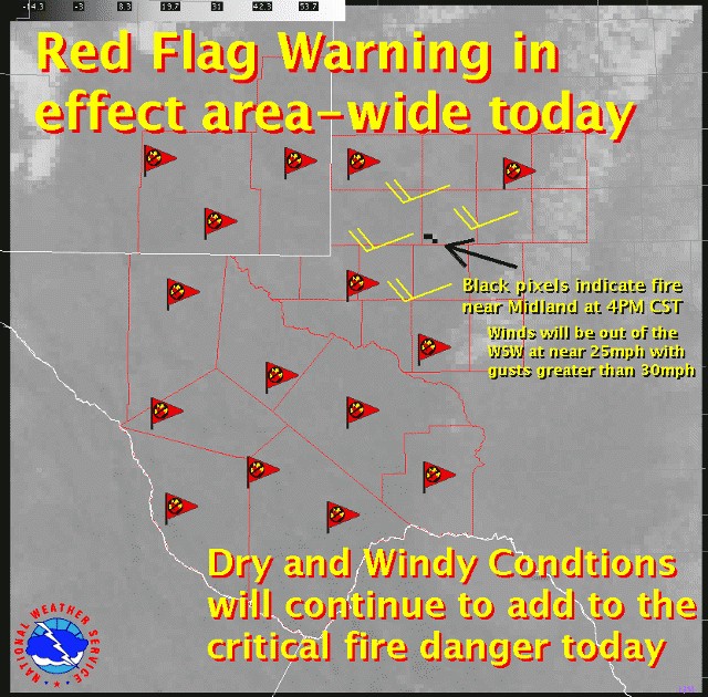
A big change in weather is in store for tonight and Monday. Currently, unseasonably warm temperatures and very dry and windy conditions continue to contribute to critical fire danger across much of the area. That will continue into the early overnight hours ahead of a cold front that will be moving through the area later this evening.
Winds ahead of the front continue to be sustained near 25 mph with gusts higher than 30 mph, sometimes gusting greater than 40 mph! Expect the winds to begin shifting around to a more westerly direction this evening before the front moves through. Once the front comes screaming through the area, northerly winds behind it will continue to blow near 25 mph with gusts continued above 30 mph.
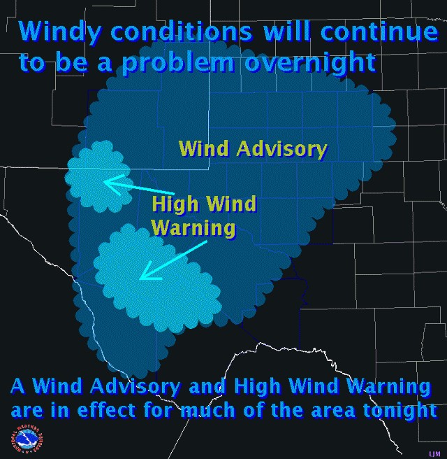
A Wind Advisory will be in effect overnight and into early Monday morning for much of the area. A High Wind Warning will remain in effect for the west Texas and Southeast New Mexico mountains as well through early Monday morning. Expect sustained winds of 45 to 55 mph with gusts to near 75 mph in the mountains tonight. The winds will remain out of the southwest until after the cold front moves through when they will shift around from a more northerly direction.
To further complicate things, snow will be possible across the extreme northern portions of the area and into the mountains. With the strong winds, blowing snow could possibly reduce visibilities across portions of southeast New Mexico tonight and into Monday morning. A Snow and Blowing Snow Advisory is in effect tonight until near lunchtime Monday. Expect snow accumulations of 1 to 2 inches in these areas with lowered visibilities and drifting snow possible.
Highs on Monday will be considerably colder than the recent mild temperatures that have occured across west Texas and southeast New Mexico. Be prepared for the abrupt change!
Other Recent Headlines:
10/4/2008 - WINDS AND SEVERE WEATHER POSSIBLE
|
|||||||
|
||||||||