|

| Roadside Park and Turner River Road | Concho Billy Trail and Other Photos | Clyde Butcher |

|
| Map showing location of Big Cypress National Preserve. Big Cypress Swamp lies to the west of the Everglades and grades slowly into the coastal marshes of southwest Florida. Big Cypress National Preserve, Corkscrew Swamp Sanctuary and Fakahatchee Strand State Preserve all offer access into the mystical cypress swampland of Big Cypress Swamp and perhaps an encounter with some of the swamp’s inhabitants such as snakes, alligators, bobcats, deer, black bears and Florida panthers. |
Big Cypress National Preserve is located in South Florida, between Naples and Miami, along the western border of Everglades National Park. Three major highways: I-75 (Alligator Alley), US 41 (Tamiami Trail) and State Road 29, provide access to the preserve.
| The "Big" in Big Cypress Swamp refers to the size of the swamp, which consists of more than 2,400 mi2. |
In the 1930’s and 1940’s, much of the old-growth cypress tree strands were logged and the trees came close to being wiped out. Land development in the 1960’s began the drainage of the swamp. In 1968, plans for an international airport along the swamp's eastern edge were revealed. The threat to Everglades National Park's watershed encouraged the establishment of The Big Cypress National Preserve in 1974.
The preserve was created to protect the natural system and water resources flowing into Everglades National Park, and to protect the recreational values of the area. As a result, activities not allowed in most national parks such as oil drilling, cattle grazing, privately owned camps, hunting and off-road vehicle use, are permitted.
| Swamps are generally wet, wooded areas where standing water of depths from a few inches to a few feet can occur for much of the year. Swamps are often referred to as strands, sloughs, estuaries, bogs, domes, bayheads and bottomlands. |
|
| The term "slough" is pronounced slew. Sloughs contain areas of slightly deeper water and a slow current. They can be thought of as the "broad, shallow rivers of the Everglades". |
Today the preserve totals more than 700,000 acres, about 2/3 of which are covered with cypress. In addition to cypress swamp, the preserve also contains freshwater marsh, dry and wet prairie, hardwood hammocks, pineland and estuarine mangrove forests. Small variations in elevation (in some cases, only inches), water salinity, soil type and fire frequency dictate which landscape community will prevail.
For more information, please visit the Big Cypress National Preserve website.
Visit with some alligators at the H.P. Williams Roadside Park, or see the plants and animals along Turner River Road.
| H.P. Williams Roadside Park |
H.P. Williams Roadside Park is located at the intersection of US 41 (Tamiami Trail) and Hwy 839 (Turner River Road). This small park consists of picnic tables along a canal active with fish and alligators.
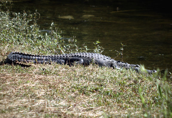
(right) An alligator basking on a canal bank near H. P. Williams Roadside Park.
Alligators are commonly seen in freshwater areas throughout Florida and throughout the Everglades. The alligator is Florida's official state reptile.
Alligators have been around since the age of dinosaurs. They can grow up to 20 feet long and can reach weights of more than half a ton. Wild alligators have a natural fear of people, however, when people feed them gators associate humans with food and lose their fear. It is very important not to feed or approach alligators.
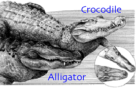
South Florida, along the southern shores of Everglades National Park, is the only place in the world where alligators and crocodiles coexist.
How do you identify an alligator from a crocodile?
Alligators have a broad and rounded snout. Crocodiles have a narrow pointed snout and its fourth tooth on the lower jaw is visible when its mouth is closed. Alligators don't have a protruding fourth tooth and when an alligators mouth is closed, usually only the upper teeth show. |
(image courtesy of Florida Power and Light Co.) |
| No swimming allowed here! |

[larger image]

[larger image]
|
(top) An alligator swimming in a canal near H. P. Williams Roadside Park. Only the alligator's head and part of its back are visible above the water when an alligator swims at the surface. This makes it easier for an alligator to approach its prey undetected. Foods an alligator may eat include fish, turtles, mammals, birds, dead animals and other alligators.
(bottom) Alligators basking on a canal bank near H. P. Williams Roadside Park. Alligators are cold-blooded, therefore their body temperatures adjust to surrounding temperatures
|
Turner River Road is located north, off of the US 41 (Tamiami Trail). A drive along this dirt road takes you through mostly open prairie interspersed with slash pine and along canals frequented by birds and alligators.
| Air Plants |
| All along Turner River Road, high in the treetops, cardinal wild pine (Tillandsia fasciculata) bromeliads were in bloom. This epiphyte ("air plant") is self-sufficient and uses other plants only for support. Epiphytes receive their nourishment from falling organic debris and rainfall trapped by the plant. |

[larger image] |
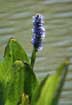
| Pickerelweed |
[larger image] |
Close-up of a pickerelweed flower spike. The violet-blue flower spikes of this aquatic is generally between 2 and 6-inches long.
Pickerelweed commonly grows in calm waters throughout Florida and generally blooms in all but the winter months.
|

[larger image] |
Mashed (Duck) Potatoes? |
(right) Duck potato (Sagittaria falcata) growing in canal waters along Turner River Road (839). White duck potato flowers grow on stalks above the plants elliptical leaves. Leaves are typically 4 inches wide and up to 2 feet long.
(left) Close-up of duck potato. The 3-petaled white flowers of this native aquatic are usually 1 to 1.5-inches across. Duck potato commonly grows in marshes, swamps and calm waters throughout Florida and generally blooms in all but the fall months.
|

[larger image] |
| Panoramic of Big Cypress NP |

Looking northwest from Turner River Road across open prairie interspersed with slash pine. [larger image] |
Related SOFIA Information
Below we have listed science projects and publications for studies that are being conducted, or have been conducted, in the area of Big Cypress National Preserve. Follow these links to read about each project and to see project-related publications and data.
Science Projects:
Related Publications:
TOP
|