California Water Science Center
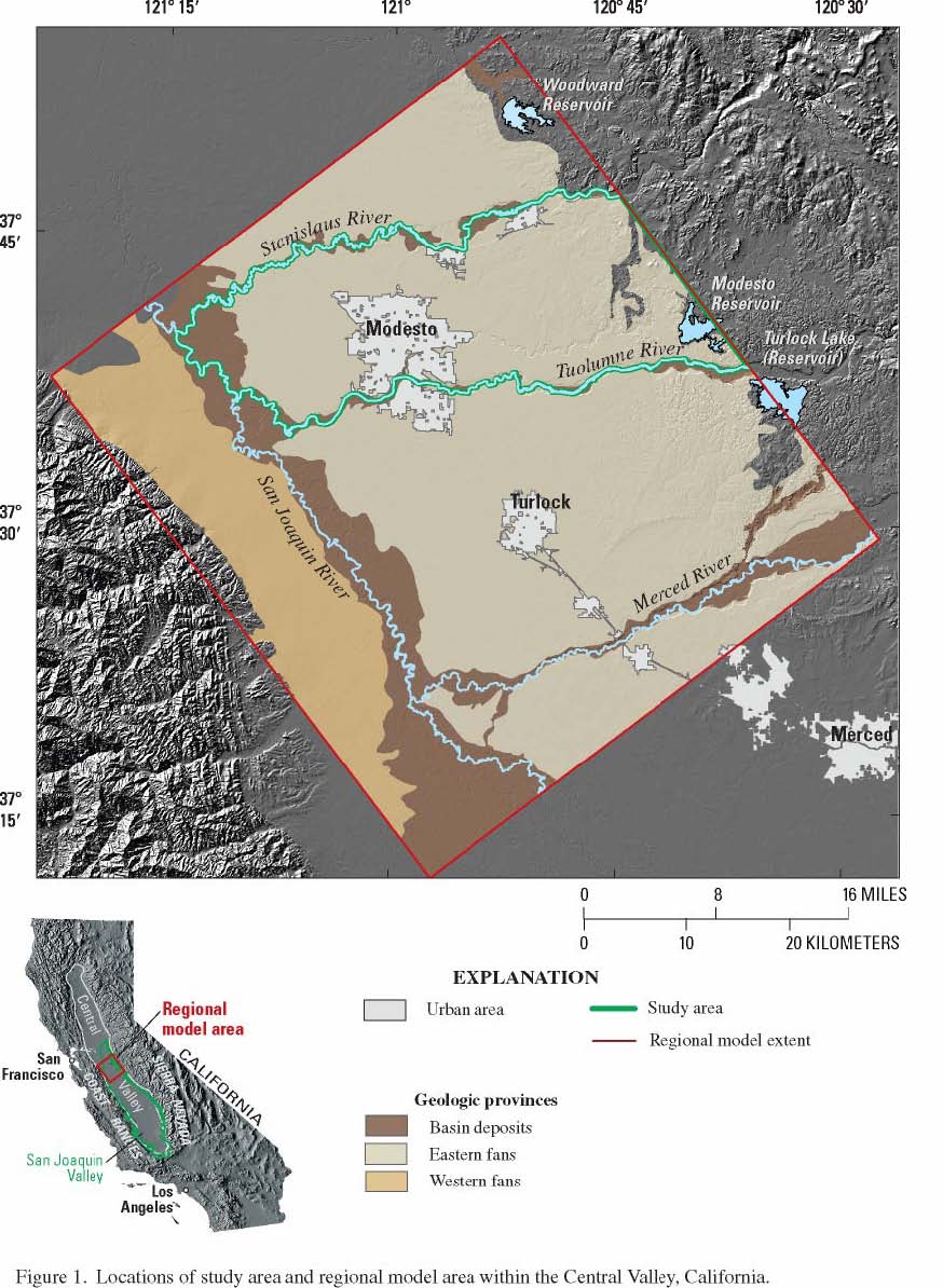
Development Of A Simulation/Optimization Model Of The Modesto Area Ground-Water Basin For Evaluation Of Water Resource Management AlternativesProject Chief: Steve Phillips Urban water use has been increasing in the Modesto ground-water basin as a result of rapid population growth, and is expected to continue or accelerate. Accompanying this increase are growing incidences of water quality problems and associated abandonment of public supply wells (14 wells in Modesto alone). Agricultural issues include vast areas underlain by a shallow water table, variable quality of water pumped to lower the water table, limited surface storage for pristine surface water, and increased early-season runoff resulting from global warming. The population in the State of California is expected to increase by about 20 million people in the next 25 years. Cities in the Central Valley are among those with the highest growth rates in the Nation, resulting in urbanization of adjacent farmlands. Although about 90 percent of the current water demands in Stanislaus County are for irrigation, the population in the Modesto area increased by 10 percent in the 1990's (U.S. Census Bureau, 1997). Surface water is the dominant water supply in Stanislaus County, supplying 62 percent of water demands in 1995; however, an increased reliance on ground water is expected during dry years and as a result of increasing demands for municipal drinking water supplies and a gradual shift in timing and intensity of runoff with global warming. Existing surface storage capacity provides limited protection against multi-year droughts, and cannot capture much of the early-season runoff without sacrificing flood protection. Rapid early-season runoff also will likely result in reduced ground-water recharge associated with losing streams. Accompanying the increased reliance on ground water is an increased incidence of public supply wells exceeding regulatory water-quality thresholds. Fourteen wells in Modesto alone were shut down during the last seven years from uranium contamination. A key agricultural issue in Stanislaus County is associated with a large area adjacent to the San Joaquin River underlain by shallow ground water. In the Modesto area, agricultural viability is maintained by pumping shallow wells to lower the water table. Some of this pumped water is of poor quality, resulting in the need for blending with surface water or disposal. This combination of factors creates a need for reliable tools to evaluate various management strategies for ensuring adequate long-term water supplies. To efficiently manage the water resources of this basin and to ensure an adequate water supply during drought years and in anticipation of increased urbanization, optimization of the water resources is needed. Previous work on this project has resulted in a detailed understanding of the hydrogeologic setting and water budget, and a transient ground-water flow model from 1960-2004. This project will provide tools to help the Stanislaus and Tuolumne Rivers Groundwater Basin Association efficiently manage the water resource.
ReportsBurow, K.R., Shelton, J.L., Hevesi, J.A., and Weissmann, G.S., 2004, Hydrogeologic characterization of the Modesto area, San Joaquin Valley California: U.S. Geological Scientific Investigations Report 2004-5232, 54 p. Contact InformationSteve Phillips
|

![]() U.S. Department of the Interior | U.S.
Geological Survey
U.S. Department of the Interior | U.S.
Geological Survey
URL: http://
ca.water.usgs.gov
/projects/CA08C.html
Page Contact Information: gs-w-cadist_www@usgs.gov
Page Last Modified:
Wednesday, 14-May-2008 12:52:50 EDT