A series of strong winter storms struck the Inland Northwest starting on Saturday 1 Dec 2007 and continuing through Monday 3 December.
On Saturday morning, a deep cold air mass covered the Pacific Northwest. The figure below shows the low temperatures on Saturday morning.

A low pressure center developed off the Washington coast on Saturday. Light snow began during the afternoon, mainly north of Interstate 90. By Sunday morning 2-3" of light fluffy snow had fallen north of I-90, with as much as 6-8" of snow in the valleys near the Canadian border.
A much stronger series of storms was approaching the Northwest at this time. But these storms were due to arrive from the southwest bringing moisture and warmer air to the region. The satellite picture below shows the remnants of a typhoon off the coast of Japan on Thursday. The moisture from this system was caught up in the jet stream and brought across the Pacific into the Northwest US.

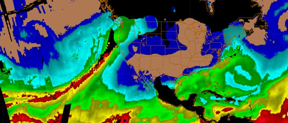
The image below is a satellite measurement of precipitable water. This is a way of showing moist and dry areas in the atmosphere. The green and red colors indicate high moisture. This image was taken midday on 3 December. Note the plume of high moisture from the subtropics (near Hawaii) to the Pacific Northwest.
The result was a typical shoving match. The cold air in place over us was slowly pushed to the north as this warm Pacific air collided with it. The movie loop shows this graphically. The temperatures are shaded where sub-freezing air is colored blue, purple and white, while above-freezing air is shown in shades of green, yellow and red. The loop starts on Saturday afternoon and ends Tuesday morning. The movie loop shows the cold air pushed to the north by the warmer air coming up from the southwest. The black arrows indicate wind speed and direction.

When this collision occurs, heavy precipitation is the result. While most of the precipitation started as snow, it gradually changed to rain on Sunday as the warmer air moved northward. The locations that remained snowing the longest were in the Cascades as well as the valleys near the Canadian border. Some of the valley locations in the Cascades received up to 3 feet of snow during these storms. The Wenatchee area also received some freezing rain before the temperatures warmed above freezing.

The heavy snow followed by rain caused minor flooding in southeast Washington and the southern Idaho Panhandle areas. The storm total precipitation (shown below) was rather impressive for this series of storms. The numbers in white are from valley weather stations, while the numbers is blue are taken from remote mountain weather stations. Even more rain fell over western Washington where flooding was widespread. A section of Interstate 5 was closed due to flooding.

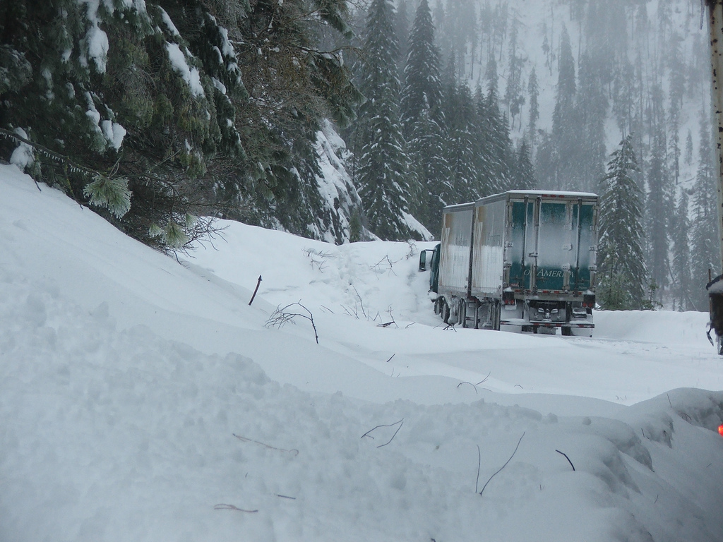
The heavy snow and rain also caused avalanches in the Cascades. The Washington state DOT reported that avalanches closed Highway 2 east of Stevens Pass early Monday morning. Three semi trucks and a state trooper were trapped between the snow slides between 2-3 am. DOT crews were able to clear enough snow to free the motorists. The picture below shows a semi stuck in a 17 foot snow slide near Tumwater canyon.
|


