Spokane NWS Precipitation
A look at Precipitation
for the 2003-2004 Water Year
Jeremy Harbeck
Hydrological years are measured from
October 1st, to September 30th. The following graphs report the precipitation
at various stations from the beginning of the 2004 hydrological year through
June. The blue line represents the normal amount of rain expected to be received,
based upon a 30 year average at that station. The yellow line represents the
actual rain reported from observations taken daily at each site.
Spokane has been below average throughout
the entire year. October to mid-November was fairly dry. However, from the last
part of October into December precipitation was much more pronounced, bringing
totals back up to a near normal amount. Starting in mid-December a slightly
below average amount was maintained, leaving Spokane a half-inch below normal
by February. A marked dry trend began in February, with only three main precipitation
events until mid-May. The total of these three events amounted to only slightly
over two inches in the three month span. This dry trend came to an end with
the large amount of rain that was received beginning on May 20th. Over the next
two days more than two and a half inches of rain fell. This event combined with
another small one in June brought totals back to near normal amounts by the
end of June.

Back to Top
Beginning at the onset of winter
Lewiston was dry and over an inch and a half below normal. Due to many precipitation
events December was rather wet and amounts were brought back up to near normal.
Rates matched average until mid-March at which point a dry spell ensued. This
period is similar to the one seen previously in Spokane, except for one added
rain event in April which contributed an additional inch. This added event combined
with the rains beginning again on May 10th were, unlike Spokane, enough to bring
the total precipitation amounts for Lewiston back up above the normal. The remainder
of the period was dry, except for two significant events, one on the 8th giving
us .46'' and one on the 19th giving us .41''. Both of these were crucial to
keeping the precipitation above the normal.

Back to Top
Wenatchee began the season relatively
dry, with one small brief event bringing above normal amounts, it was short-lived
however. From November until late-January most days were dry, interspersed with
moderate events that kept Wenatchee close to its normal. Then in early February
the sporadic precipitation was small and Wenatchee fell behind. There was a
marked change in the latter half of the month, in which the total precipitation
went from 3.05'' on the 15th to 5.04'' on the 25th in just three events. This
was followed by another dry period until May 10th which started a wet trend
that brought over another inch of rain and Wenatchee back up above its normal.
This was essentially the end of the precipitation for the season in Wenatchee.

Back to Top
Winthrop began with a drier October,
which set the stage for an overall below average year. A normal amount fell
from November to mid-March keeping Winthrop just below its average. Less fell
after this, bringing a drier two months starting in mid-March. This dry patch
was broken by an extremely wet period extending from May 16th to the 30th in
which 8.24'' of rain fell. This combined with another 1.38'' that fell on the
6th, 7th and 8th of June were still not enough to cancel out the previous dryness
and bring Winthrop back up to the usual total here of 17'' for the year. Little
precip has been received since these events making June drier than normal.

Back to Top
Mazama had two extremely large events
in a dry period early on in the season, one on the 20th of October and another
on the 18th of November, bringing them 3.23'' and 2.29'' of precipitation, respectively.
An average amount of precip fell up until the first of the year, at which point
a drier trend ensued. The rate of precipitation continued until late May, however
the normal rate was matched as precipitation tends to usually fall off at the
beginning of spring. June is accented with the usual amount of sporadic rain
due mainly to thunderstorms.

Back to Top
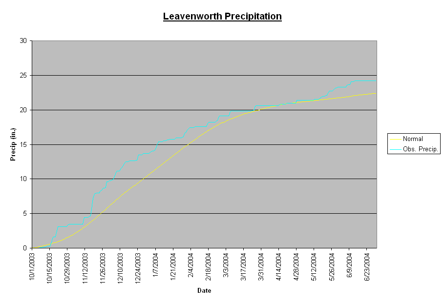
October was relatively dry except
for one major event which dropped over an inch and a half of rain on the 20th
and 21st. This was followed by another large event on the 17th and 18th in which
2.58'' of precipitation fell. After this good start to the year Leavenworth
leveled out and remained on par with their average until the first of the year,
at which point precip began to slacken. From January until May less and less
precipitation is received, bringing the accumulated precip down to the normal
of 20.64'' on April 13th. This trend is reversed however in the latter half
of May in which a wetter trend returns and brings 1.73 more inches of rain.
June so far has received little precipitation.
Back to Top
Republic began the year out with
a few precipitation events, but in mid to late October was below average for
nearly a month. Beginning in December however, rates reached normal amounts
and accumulated precip continued to follow just below the normal trend. This
pattern persisted up until early-March, at which point a dryer trend ensued
up until May 11th, broken only by two small rains centered around February and
March 26th. A much wetter trend begins on the 11th of May, slowly bringing the
accumulated precip back up the normal levels. One noteworthy event, on the 25th
of June, brought 1.62'' of Rain in one day.

Back to Top
Lind began the year with less rain
than normal, but quickly made up for it with the wet period of mid-November
to mid-December, evident as well in Spokane, Lewiston, Porthill and on many
other graphs. This section was wet enough though, to bring Lind above their
normal accumulated precip. After remaining at their normal rate for a month,
Lind increased in precipitation from February to March, then had less for the
next month and a half. April 14th brought the start of more rain, with .2''
over the next two days, followed by .38'' a few days later. This stepping trend
continues for the rest of the season, similar to Wenatchee and other locations
known for rainstorms which bring sporadic precipitation events.

Back to Top
Porthill had a wet end of October,
a dry first-half of November, followed by another month of above average precipitation.
December 15th showed the beginning of a drier trend for another month, which
ended with increased rainfall in the end of January. February until May had
slightly less than average precipitation, with the greatest rainfall dropping
.97 of an inch down over a two day period. June brought 1.07'' of rain on the
6th and 7th, after which precipitation continues at a normal rate.

Back to Top
Moscow began drier than usual, having
only a few rain events, but soon picked up in mid November to bring the accumulated
precip back to normal by mid-December. Precipitation remained the closest of
any station to near normal until mid-January, where it then begins to waver.
The station falls below then above the normal, but maintains a near average
amount of precipitation until March 6th, at which point a dry trend is entered.
This lasts until May when on the 16th it changes to a wetter pattern and by
the end of the month 3.95'' of precipitation has fallen.

Back to Top
Beginning in October Kellogg was
slightly above average in total precipitation received. Then in mid-November
rates increased for approximately a month starting winter off wetter than normal.
Precipitation continued slightly below until February and then returned to normal
until mid-May with a few larger events including one on February 16th and 17th
that precipitated out 1.13'' and another March 25th, 26th and 27th that precipitated
1.43''. The end of May was extremely wet dropping over 3'' of rain after the
19th. June has been somewhat below normal, but this dry trend is not enough
to negate the fact that the season remains above average.

Back to Top
|


