|


|
|
04/27/00 Thunderstorm Event
 |
Factors that Lead
to the Development of Elevated Daytime Thunderstorms 4/27/00
Don Moore & Paul Bos -
WFO Spokane
|
Introduction
Thunderstorms developed over
Eastern Oregon the afternoon of April 27, 2000 and quickly spread across
Eastern Washington and North Idaho. The thunderstorms moved north at 50
mph and produced a tremendous amount of lightning, heavy rain, and pea
to dime sized hail. Despite the rapid movement of storms, winds gusts
associated with the thunderstorms were under 20 mph.
The weather pattern on April
27th was typical for thunderstorm development in the Inland
Northwest. The set up was the approach of a slightly negatively tilted
trough with strong upper level forcing for rising motion. Even though
the weather pattern was common for thunderstorm development, there were
several factors that made this a unique storm system for the Inland Northwest.
Among the more interesting aspects was the elevated nature of the thunderstorms,
despite the development of storms during maximum heating. This overview
will detail the forcing mechanisms that helped produce the storms as well
as additional interesting aspects of the event.
|
|
Synoptic and Mesoscale Environment
A deep low pressure system was
slowly moving northeast toward the British Columbia coast on April 27, 2000.
A short wave or upper level disturbance was rounding the base of the trough
the morning the 27th. As this short wave swung around the trough
and toward the coast, the upper level trough began to take on a slight negative
tilt, which increased the rising motion due to strong upper level divergence.
Meanwhile, a jet streak was heading north along the Oregon coast. The influence
of this jet can be seen in water vapor imagery (right) by the enhancement
of cirrus over Washington between 4/27/00 21z and 4/28/00 01Z. The passage
of the jet streak through Washington ahead of the trough, enhanced the upward
motion over Eastern Washington and North Idaho and lead to the development
of thunderstorms. The lagging short wave trough eventually pin-wheeled into
Eastern Washington and North Idaho overnight on the 27th and
brought widespread showers to the area.
|
 |
 At the surface, a cold front was
pushing across the Cascade Crest around 4/28/00 00Z. A stationary surface
trough was also situated across central Washington and generally extended
from near Moses Lake, WA to Pendelton, OR around 4/28/00 00Z. Easterly flow
on the east side of the surface trough produced weak cold air advection
while good surface convergence existed along the trough axis. In the mid
levels, strong southerly flow existed, which resulted in an impressive vertical
wind shear profile in Eastern Washington.
At the surface, a cold front was
pushing across the Cascade Crest around 4/28/00 00Z. A stationary surface
trough was also situated across central Washington and generally extended
from near Moses Lake, WA to Pendelton, OR around 4/28/00 00Z. Easterly flow
on the east side of the surface trough produced weak cold air advection
while good surface convergence existed along the trough axis. In the mid
levels, strong southerly flow existed, which resulted in an impressive vertical
wind shear profile in Eastern Washington.
Even with easterly surface
flow and weak cold air advection at Spokane and Pullman, surface dewpoints
rose steadily through the afternoon (see surface observations left). The
relatively high dewpoints resulted in surface-based CAPE of 500 to near
1000 J/KG, with the highest CAPE values over the Washington Palouse. Despite
strong surface convergence, relatively warm 850-700mb temperatures and
weak surface cold air advection prevented the development of surface based
cumulus clouds through the evening. As a result, the 500 to 1000 J/KG
of surface-based CAPE was not utilized on the 27th +
.
|
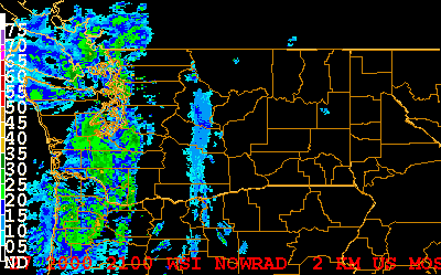
| Instead, altocumulus
castellanus developed. The development of these clouds were associated with
steep mid level lapse rates and a jet streak that likely helped increase
the instability via deep vertical motion. The castellanus quickly developed
into thunderstorms with cloud bases near 10,000 feet AGL (cloud to ground
lightning strikes are noted by the cyan markings on the visible imagery
above). Thunderstorm development occurred and was aligned with the region
of greatest middle level potential (convective) instability, as seen by
the decrease in equivalent potential temperature between 700 and 500 mb
(see AVN forecast of differential
equivalent potential temperature). Surface based cumulus clouds were
not observed in the vicinity of Spokane through the afternoon and evening
(the picture at the top of the page shows the high based thunderstorms as
they moved toward the NWS in Spokane, WA).
Thunderstorms tops on the
27th peaked around 33,000 feet AGL while cloud bases were around
10,000 feet AGL. The storms were steered by the 700-500 mb winds, which
were southerly at 50 mph. Despite the rapid movement of the storms, strong
surface wind gusts were not reported (another indication the thunderstorms
were not surface based). Despite the fairly shallow nature of these storms,
0.25 to 0.50 inch sized hail was produced by several storms. One isolated
thunderstorm produced 0.75 inch sized hail in eastern sections of Spokane.
A modified sounding for Spokane, based on lifting from 700 mb, predicts
the observed conditions (see
modified RAOB and observed
RAOB ).
|
 |
Conclusions
The approach of a slightly negatively
tilted the afternoon and evening of 4/27/00 was classic for thunderstorm
development. This pattern provided Eastern Washington and North Idaho with
good upper level forcing, including 200-300mb divergence associated with
a jet streak and 500-300mb Q-vector convergence. Near surface conditions
were not favorable though. The most significant inhibiting factor was low
level cold air advection. This prevented deep, surfaced-based, moist convection
(see 4/28/00 initialized
00Z Eta for depiction of significant features). Amazingly, the observed
4/28/00 00Z Spokane RAOB
indicated the boundary layer was only 25 mb deep. Strong 700-300 mb upward
motion was a critical factor that lead to the development of elevated thunderstorms.
Mid level instability that was in place over Eastern Washington and North
Idaho prior to thunderstorm development was another important parameter.
However, the deep vertical motion likely played an important role in increasing
the mid level instability further. Based on the evolution of events on 04/27/00,
forecasters should realize that upper level forcing (associated with a negatively
tilted trough) combined with middle level instability may be sufficient
for the generation of strong to severe thunderstorms. |
|
+ Ironically,
the same 850-700mb temperatures that inhibited the development of surface
based cumulus prevented moisture that was evaporating from the ground
from mixing out. This is likely why surface dewpoints rose through the
day while low level easterly flow existed.
|
|
|
|
Webmaster
US Dept of Commerce
National Oceanic and Atmospheric Administration
National Weather Service
Spokane Weather Forecast Office
2601 N. Rambo Rd.
Spokane, Washington 99224
Tel: (509) 244-0110
|
Disclaimer
Information Quality
Credits
Glossary |
Privacy Policy
Freedom of Information Act
About Us
Career Opportunities
|
National Weather Service Mission: "The
National Weather Service (NWS) provides weather,
hydrologic, and climate forecasts and warnings for
the United States, its territories, adjacent waters
and ocean areas, for the protection of life and
property and the enhancement of the national economy.
NWS data and products form a national information
database and infrastructure which can be used by
other governmental agencies, the private sector,
the public, and the global community." |
|
|


