|
|
 |
|
 |
|
Oklahoma Home
|
|
|
|
|
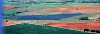
Upper Washita WatershedUpper Washita Watershed InformationThe 2,054,359 acre Upper Washita Watershed contains 3429 farms and is located entirely in southwestern Oklahoma. It is comprised of portions of Beckham, Caddo, Canadian, Comanche, Custer, Dewey, Grady, Kiowa, and Washita counties. The land use is about 40% cropland, 45% grazing land and 5% woodland, wildlife land and recreation. The primary crops are wheat, peanuts, and cotton. Pastures typically consist of native or improved grasses such as Bermuda grass or Old World Bluestem. The livestock enterprise is chiefly beef cattle. There are four Nutrient Limited Watersheds within this watershed: Crowder Lake, Clinton Lake, Ft. Cobb Lake, and Lake Vanderworth. The primary resource concerns on cropland are water erosion, excessive nutrients and organics in surface water, and excessive runoff, flooding or ponding. The primary resource concerns on grazing lands are noxious and invasive plants and wildlife habitat. The resource concern to be met in order to qualify for Tier II is noxious and invasive plants. Acres by Land Use within the Upper Washita Watershed A rapid watershed assessment has been completed on the Upper Washita Watershed. Additional information about the watershed is available from links within the following document.
The following document requires
Adobe Acrobat. Upper Washita Watershed Map and County Maps in Watershed
The following documents require
Adobe Acrobat. CSP Program Tools
The following documents require
Adobe Acrobat. Additional InformationFor further information and assistance, contact the NRCS Field Office in: Beckham County - Sayre Field Office Oklahoma NRCS CSP ContactsBrandy Pietz-Jones Steve Kelley Richard Zetterberg For additional information go to Oklahoma CSP Description and Application Information http://www.ok.nrcs.usda.gov/programs/csp/cspnarrative.html For national information and the watersheds approved nationally go to http://www.nrcs.usda.gov/programs/csp/CSP_2008/2008_CSP_WS.html Last Reviewed/Modified: 05/27/2008 |
|
|
|
