National Water-Quality Assessment (NAWQA) Program
Go to:
PublicationsAbout the maps--
Fact sheet--
Detailed report--
Research--
|
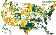
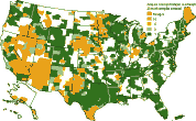
Arsenic in ground water is largely the result of minerals dissolving from weathered rocks and soils. Several types of cancer have been linked to arsenic in water. In 2001 the US Environmental Protection Agency lowered the maximum level of arsenic permitted in drinking water from 50 micrograms per liter (ug/L) to 10 ug/L. The USGS has developed maps that show where and to what extent arsenic occurs in ground water across the country. The current maps are based on samples from 31,350 wells. Widespread high concentrations were found in the West, the Midwest, and the Northeast. For help interpreting these maps, see: |
Updated mapsEqual-area map--
County map--
Data map--
|
DataUSGS data--
State data--
|
Arsenic linksWorld Health Organization-- Arsenic in drinking water US Environmental Protection Agency-- Basic information, Arsenic Standard, and Consumer info on arsenic in drinking water (pdf) US Congressional Research Service-- CRS Report for Congress on Arsenic in drinking water National Research Council-- Arsenic in drinking water and 2001 Update West Bengal & Bangladesh Arsenic Crisis Information Centre |

![]() U.S. Department of the Interior |
U.S. Geological Survey
U.S. Department of the Interior |
U.S. Geological Survey
URL: http://water.usgs.gov/nawqa/trace/arsenic/
Page Contact Information: traceweb@usgs.gov
Page Last Modified: 14:26:27 Fri 29 Aug 2008