U.S. - Mexico Border Environmental Health Initiative

Project Description

Project Objectives

Maps & Data

   Internet Mapping Service

   Data Download

   Static Map Library

   Data Tables

Methods/Documentation

Publications

Acknowledgements & Links

Internet Mapping Service

Please click on a Project Area to enter the Internet Mapping Service or Borderwide

Border Regions - click on an area to view its respective IMS view Sub-area 8:  The Lower Rio Grande Valley Subarea 7:  The Rio Grande: Below Amistad Reservoir to Falcon Resevoir Subarea 6:  The Rio Grande: Rio Conchos to Amistad Reservoir Subarea 5:  The Rio Grande: Elephant Butte Reservoir to above Rio Conchos Subarea 4:  San Basilio-Mimbres Subarea 3:  The Mexican Highlands Subarea 2:  The Colorado River-Sea of Cortez Subarea 1:  Pacific Basins-Salton Trough

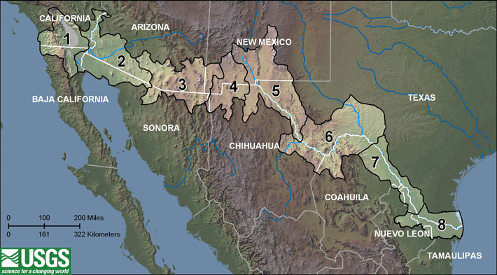
For a description of subareas click here.

View:

bulletBorderwide

bulletSubarea 8: The Lower Rio Grande Valley

bulletSubarea 7: The Rio Grande: below Amistad Reservoir to Falcon Resevoir

bulletSubarea 6: The Rio Grande: Rio Conchos to Amistad Reservoir

bulletSubarea 5: The Rio Grande: Elephant Butte Reservoir to above Rio Conchos

bulletSubarea 4: San Basilio-Mimbres

bulletSubarea 3: The Mexican Highlands

bulletSubarea 2: The Colorado River-Sea of Cortez

bulletSubarea 1: Pacific Basins-Salton Trough

See subarea descriptions

Accessibility FOIA Privacy Policies and Notices

Take Pride in America home page.FirstGov buttonU.S. Department of the Interior | U.S. Geological Survey
URL: http://borderhealth.cr.usgs.gov/
Page Contact Information: gs-w-tx_webmaster@usgs.gov
Page Last Modified: October 10, 2008