|

Wireless Sensor Networks Workshop Sept. 16 - 17
Released: 9/27/2008
The USGS Geography Discipline is hosting a two-day Wireless Sensor Network workshop at the Winter Park Lodge, Winter Park Colorado on September 16th and 17th, 2008.
RFI: Landsat Raw Data Products
Released: 8/14/2008
The US Geological Survey seeks information to determine if there is interest by one or more commercial or non-profit vendors in offering Landsat products beyond those available from the US Geological Survey (USGS). The USGS has available Landsat TM and ETM+ data in a raw, uncorrected format (Level-0R) so that these data could be processed to user specifications (projection, datum, and resampling method). Responses are due by September 12, 2008. Details can be found at FedBizOpps.
DOI Secretary Kempthorne Showcases Free Public Availability of Landsat Image Archive at ESRI Conference
Released: 8/5/2008
"With the click of a mouse, scientists, government officials and land managers will be able to see the changes in the earth's landscape at any point in the past three and a half decades," Kempthorne told the audience on Saturday. News Release U.S. Department of the Interior
USGS Accelerates Access to Satellite Data
Released: 7/1/2008
Federal and state agencies that need satellite imagery from commercial sources will find it much easier to acquire the data through a streamlined process managed by the U.S. Geological Survey. Read more...
Visit the Latest Archive page for information highlighted here in the past.
|

Cyclone Nargis — 2008
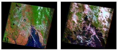
Landsat satellite imagery, acquired shortly before and after Cyclone Nargis hit the coastal region of Myanamr on May 3, 2008, illustrate the flooding and destruction caused by the cyclone. The delta region, which is home to one fourth of Myanmar’s 57 million people, is a major agricultural area and its lowlands make it especially susceptible to flooding. The cyclone created a 3.6 meter storm surge which devastated the area. At least 22,000 deaths have been reported, with 41,000 listed as missing. Over 1 million are homeless. Learn More.

The White House has initiated a
year-long study called The Future of Land Imaging to
explore options for United States operational use of
satellites to better serve society. The USGS serves on
the leadership team of this Federal interagency working
group.
|
|


