|
|


|
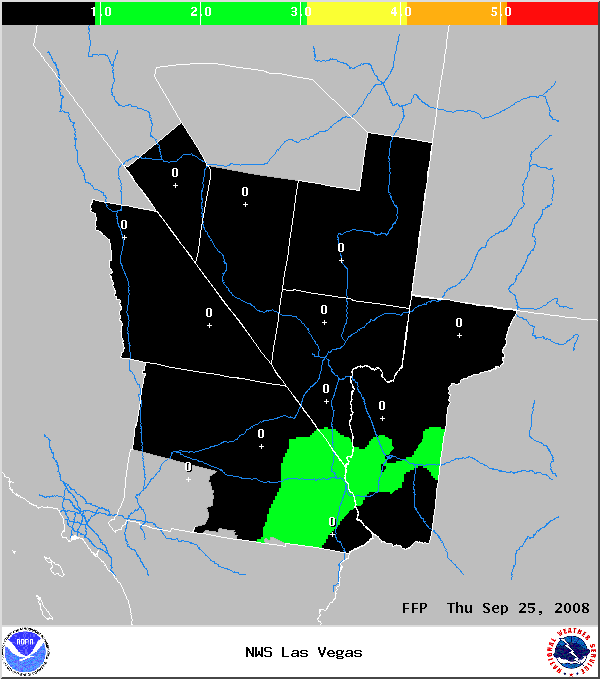
FLASH FLOOD POTENTIAL INDEX
NOAA's National Weather Service - Las Vegas, Nevada
These graphics are designed to
provide guidance information on the potential
for, and areal coverage of, significant flash
flooding during the next three days over the
area for which NWS Las Vegas has forecast responsibility.
The index ratings are based on forecasts of
precipitable water and mean winds in the 700-400
mb layer, conditional upon the development of
thunderstorms. There is no explicit probabilistic
information, although any threat area occurring
within a zone where the probability of precipitation
is forecast to be less than 30% is constrained
to a low risk rating. Information on interpreting
index ratings can be found at the bottom of
this page.
These images are not intended to be used as
stand alone products for operational planning
and decision making. They are being created
from a digital forecast data base as a resource
for adding value to the traditional, official
forecast products routinely generated by NOAA's
National Weather Service. The product is refreshed
each evening, generally after 9 PM PDT. The
evening issuance is valid for the following
three days (Day 1 representing "tomorrow").
Morning updates (Day 1 representing "today")
will be produced between 9 and 11 AM PDT.
|
FFPI - Day 1
|
|
FFPI
- Day 2

|
|
FFPI
- Day 3

|
|
FLASH
FLOOD POTENTIAL INDEX
Color Key and Explanation
Red
(index value=6): "VERY HIGH RISK"
(Conditional upon the formation
of thunderstorms, rain rates exceeding
1.00" in a period of 30 minutes or less
are possible)
Orange
(index value=5): "HIGH RISK"
(Conditional upon the formation of
thunderstorms, rain rates of 0.75-1.00"
in a period of 30 minutes or less are
possible)
Yellow
(index value=4): "MODERATE RISK"
(Conditional upon the formation of
thunderstorms, rain rates of 0.50-0.75"
in a period of 30 minutes or less are
possible)
Green
(index value=1-3): "LOW RISK"
(Conditional upon the formation of
thunderstorms, rain rates of 0.25-0.50"
in a period of 30 minutes or less are
possible)
Black
(index value=0): "NEGLIGIBLE RISK"
(Thunderstorms not probable; or any
thunderstorms that form are not expected
to produce a serious flash flood threat)
(All
locations outside the WFO Las Vegas area
of forecast responsibility are colored
gray.)
|
|
|
|
Webmaster
US Dept of Commerce
National Oceanic and Atmospheric Administration
National Weather Service
Las Vegas Weather Forecast Office
7851 S Dean Martin Dr.
Las Vegas, NV 89139-6628
Tel: (702) 263-9744
|
Disclaimer
Information Quality
Credits
Glossary |
Privacy Policy
Freedom of Information Act
About Us
Career Opportunities
|
National Weather Service Mission: "The
National Weather Service (NWS) provides weather,
hydrologic, and climate forecasts and warnings for
the United States, its territories, adjacent waters
and ocean areas, for the protection of life and
property and the enhancement of the national economy.
NWS data and products form a national information
database and infrastructure which can be used by
other governmental agencies, the private sector,
the public, and the global community." |
|
|