
|
|
||
| Outreach in the Western Region |
| These photographs were made Web accessible in response to demands from the public and the media
for historical photographs of USGS mappers at work. All photographs within this collection are public domain. No permission is required for use or reproduction and images may be downloaded at no charge. For any use made of a photograph, credit should be given to the individual photographer (where noted) and the U.S. Geological Survey. |
|||||
|
|||||
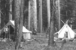
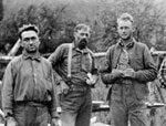
 1890-1892
R.H. Chapman camp under Live Oak in Sonora, California. Temperature is 117 degrees. Enlarge Image |
|||||
|
|
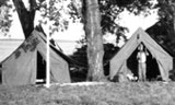
|||||
 early 1900s early 1900s USGS field camp. Enlarge Image |
|||||
|
|
|||||
 early 1900s
 Herbert "Shortie" Clark mapping with a planetable and telescopic alidade. Enlarge Image |
|||||
|
|
|||||
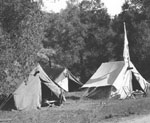
 early
1900s early
1900sUSGS field camp. Enlarge Image |
|||||
|
|
|||||
 early
1900s early
1900sUSGS field camp. Enlarge Image |
|||||
|
|
|||||
 early
1900s early
1900sUSGS field camp. Note the U.S. and USGS flags. Enlarge Image |
|||||
|
|
|||||
 1903
1903Field crew in the Cascade Mountains of Washington. A.E. Murlin photo. Enlarge Image |
|||||
|
|
|||||
 1904
1904George Davis and Ryan kindling a fire to warm numb fingers. Enlarge Image |
|||||
|
|
|||||
 1905
1905Level crew in early 1905 running a line from Mojave to Keeler, California via the state road, preparing the way for topographers to follow. Levelman and Chief of Party was R.A. Farmer, just to the left of the long-barreled Engineers WYE level instrument. Holding the umbrella (used to shield the bubble) and the notebook is either M.D. Shannon or P.E. Turner. Later that year Farmer was to run lines into Yosemite Valley and to the top of California's Mt. Whiney. Enlarge Image |
|||||
|
|
|||||
 1905
1905Elevation monument for a level line run from Mojave to Keeler, California in early 1905. The line ran through such places as 18-Mile Station, Dixie, Indian Wells, Little lake, and Olacha. Elevations were based on Benecia datum. Enlarge Image |
|||||
|
|
|||||
 circa 1906
 Horse-drawn wagon northwest of Sacramento, California. Note the U.S.G.S. initials on the seat. Enlarge Image |
|||||
|
|
|||||
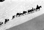 circa 1907
 A USGS packtrain carries men and equipment up a steep slope while mapping the Mount Goddard, California quadrangle. Enlarge Image |
|||||
|
|
|||||
 1907-1909
R.B. Marshall using a plane table and alidade, possibly at Mount Goddard, California. Marshall created the first topographic map of the area surrounding Menlo Park, California (future home of the Western Region USGS offices) in 1895. Marshall later served as the Chief Geographer for the USGS. In 1919, he earned the nickname "Father of the Central Valley Project" when he proposed a plan to transfer water from California's Sacramento Valley to the San Joaquin Valley via two large canals. Enlarge Image |
|||||
|
|
|||||
 1874
1874Allen Wilson (standing) and Franklin Rhodda on Sultan Mountain in Colorado. Enlarge Image |
|||||
|
|
|||||
 1911
1911 Rod man poses in Salinas Valley, California. Enlarge Image |
|||||
|
|
|||||
 1918
1918San Luis Obispo, California. Captain Straughan and rodman Bud Sullivan prepare to depart for a day in the field. The flagpole holds a United States flag and a USGS flag. Enlarge Image |
|||||
|
|
|||||
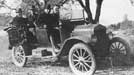 circa 1918
One of the U.S. Geological Survey's first cars. Circa 1918. From the Gerald Fitzgerald album. Enlarge Image |
|||||
|
|
|||||
 1923
1923Roland Burchard (standing) and Claude Birdseye (taking notes at right) on the Colorado River. Birdseye was the first Chief Topographic Engineer of the USGS (1919-1929) and headed a USGS expedition through the Grand Canyon in 1923 to acquire information on the hydrology, topography, and geology of the Colorado River. Enlarge Image |
|||||
|
|
|||||
 1920
1920Field crew in camp, Alaska. Enlarge Image |
|||||
|
|
|||||
 1920
1920Gerald Fitzgerald in the field in Alaska. Enlarge Image |
|||||
|
|
|||||
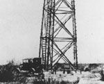 1920
1920USGS triangulation tower in West Texas. Enlarge Image |
|||||
|
|
|||||
 1921
1921Koontz holding the rod for topgrapher George Druhot near Job, West Virginia. Enlarge Image |
|||||
|
|
|||||
 circa 1920
USGS Topographer. Enlarge Image |
|||||
|
|
|||||
 circa 1920-1924
In survey camp with sled dogs. Alaska. Enlarge Image |
|||||
|
|
|||||
 circa 1920-1924
Anchorage, Alaska. The first time a plane was used to transport supplies to Topographic Survey parties. Enlarge Image |
|||||
|
|
|||||
 1924
1924Gerald Fitzgerald with dog sled team in Alaska. Enlarge Image |
|||||
|
|
|||||
 1924
1924Survey party, Alaska. Enlarge Image |
|||||
|
|
|||||
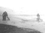
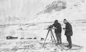 1924
1924Working with an alidade and planetable in Alaska. Transportation by dogsled, temperature well below zero. Enlarge Image |
|||||
|
|
|||||
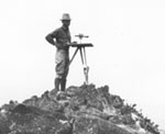 1924
1924R.R. Monbeck on the rim of Haleakala on the island of Maui, Hawaii. Enlarge Image |
|
| Privacy Accessibility Information Quality FOIA Contact Us | |
| U.S. Department of the Interior | U.S. Geological Survey URL: http://online.wr.usgs.gov/outreach/historicPhotos/historical_photos.html Page Contact Information: Western Region Web Team Page Last Modified: Thursday, 18-Jan-2007 17:13:11 EST (alv) |  |