
Magnitude 7.1 - CELEBES SEA - usuda2
2005 February 5 12:23:16 UTC
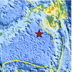
A major earthquake occurred at 12:23:16 (UTC) on Saturday, February 5, 2005. The magnitude 7.1 event has been located in the CELEBES SEA. The hypocentral depth was estimated to be 501 km (312 miles). (This event has been reviewed by a seismologist.)

Earthquake Details
| Magnitude | 7.1 |
|---|---|
| Date-Time |
= Coordinated Universal Time = local time at epicenter |
| Location | 5.358°N, 123.209°E |
| Depth | 501.3 km (311.5 miles) |
| Region | CELEBES SEA |
| Distances | 210 km (130 miles) SE of Zamboanga, Mindanao, Philippines 235 km (145 miles) WSW of General Santos, Mindanao, Philippines 1050 km (650 miles) SSE of MANILA, Philippines 2220 km (1380 miles) NE of JAKARTA, Java, Indonesia |
| Location Uncertainty | horizontal +/- 8.2 km (5.1 miles); depth +/- 13 km (8.1 miles) |
| Parameters | Nst=178, Nph=178, Dmin=>999 km, Rmss=1.14 sec, Gp= 36°, M-type=teleseismic moment magnitude (Mw), Version=Q |
| Source | USGS NEIC (WDCS-D) |
| Event ID | usuda2 |


- Preliminary Earthquake Report
- U.S. Geological Survey, National Earthquake Information Center
World Data Center for Seismology, Denver
