Magnitude 7.2 - NICOBAR ISLANDS, INDIA REGION - usaxay
2005 July 24 15:42:06 UTC
A major earthquake occurred at 15:42:06 (UTC) on Sunday, July 24, 2005.
The magnitude 7.2 event has been located in the NICOBAR ISLANDS, INDIA REGION.
(This event has been reviewed by a seismologist.)
Earthquake Summary
Felt Reports
Some buildings damaged in the Andaman and Nicobar Islands. Felt (V) on Car Nicobar, Katchal and Nancowry. Also felt (V) at Campbell Bay, Great Nicobar and Port Blair, South Andaman Island. Felt (IV) at Chennai; (III) at Srikakulam, Visakhapatnam, Vizianagaram and other coastal areas of Andhra Pradesh and at Dum Dum and Garia, West Bengal, India. Felt at Mamallapuram, India. Felt (IV) in Aceh Province, Indonesia. Felt (III) at Colombo, Matale and Kandy, Sri Lanka. Felt at Peraliya and Sri Jayawardenepura Kotte, Sri Lanka. Also felt at Male, Maldives and on Phuket, Thailand.
Tectonic Summary
This earthquake occurred near the western boundary of the aftershock zone of the devastating Sumatra-Andaman Islands earthquake of December 26, 2004. The aftershock zone of the December 26th earthquake continues to be active and forms a crescent-shaped region extending about 1200 km north of Sumatra, Indonesia. The recent event was a strike-slip earthquake, probably in the India plate below its shallowly dipping boundary with the Burma plate. The earthquake resulted from horizontal displacement of the ground across a nearly vertical fault plane. This is unlike the thrust-fault motion that produced the December 26th earthquake and that occurred on the interface of the eastward-subducting India plate and the overriding Burma plate. The recent event therefore occurred on a different fault than the fault that caused the Great Sumatra-Andaman Islands earthquake. However, the two earthquakes are almost certainly related. A great earthquake can trigger earthquake activity on faults that are distinct from the main-shock fault plane, and separated from it by tens or even hundreds of kilometers. A magnitude 7.2 earthquake is considered a major earthquake, but the size of this recent earthquake pales in comparison to the December 26th earthquake. A 7.2 strike-slip earthquake typically ruptures a 15 km by 80 km patch along a fault, whereas the December 26, 2004 earthquake ruptured a patch of fault about 1200 km long and 200 km wide.
Earthquake Information for INDIA
Earthquake Details
| Magnitude |
7.2 |
| Date-Time |
Sunday, July 24, 2005 at 15:42:06 (UTC)
= Coordinated Universal Time
Sunday, July 24, 2005 at 9:12:06 PM
= local time at epicenter
Time of Earthquake in other Time Zones
|
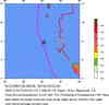
| Location |
7.909°N, 92.139°E |
| Depth |
16 km (9.9 miles) set by location program |
| Region |
NICOBAR ISLANDS, INDIA REGION |
| Distances |
135 km (85 miles) W of Misha, Nicobar Islands, India
420 km (260 miles) S of Port Blair, Andaman Islands, India
1110 km (690 miles) SW of BANGKOK, Thailand
2775 km (1720 miles) SE of NEW DELHI, Delhi, India
|
| Location Uncertainty |
horizontal +/- 4.9 km (3.0 miles); depth fixed by location program |
| Parameters |
Nst=259, Nph=259, Dmin=982.9 km, Rmss=0.91 sec, Gp= 32°,
M-type=teleseismic moment magnitude (Mw), Version=S
|
| Source |
USGS NEIC (WDCS-D)
|
| Event ID |
usaxay |
Earthquake Maps

Earthquake Location
Scientific & Technical Info
Additional Information, News Reports
This earthquake occurred near the western boundary of the aftershock zone of the devastating Sumatra-Andaman Islands earthquake of December 26, 2004. The aftershock zone of the December 26th earthquake continues to be active and forms a crescent-shaped region extending about 1200 km north of Sumatra, Indonesia. The recent event was a strike-slip earthquake, probably in the India plate below its shallowly dipping boundary with the Burma plate. The earthquake resulted from horizontal displacement of the ground across a nearly vertical fault plane. This is unlike the thrust-fault motion that produced the December 26th earthquake and that occurred on the interface of the eastward-subducting India plate and the overriding Burma plate. The recent event therefore occurred on a different fault than the fault that caused the Great Sumatra-Andaman Islands earthquake. However, the two earthquakes are almost certainly related. A great earthquake can trigger earthquake activity on faults that are distinct from the main-shock fault plane, and separated from it by tens or even hundreds of kilometers. A magnitude 7.2 earthquake is considered a major earthquake, but the size of this recent earthquake pales in comparison to the December 26th earthquake. A 7.2 strike-slip earthquake typically ruptures a 15 km by 80 km patch along a fault, whereas the December 26, 2004 earthquake ruptured a patch of fault about 1200 km long and 200 km wide.
- News Release
- Magnitude 7 and Greater Earthquakes in 2005
- Earthquake Summary Poster
- ShakeMap shaking intensity maps (Global server)
- Preliminary Earthquake Report
- U.S. Geological Survey, National Earthquake Information Center
World Data Center for Seismology, Denver