
 Feeds & Data
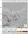
Magnitude 7.2 - XINJIANG-XIZANG BORDER REGION
2008 March 20 22:33:00 UTC
Earthquake Details
| Magnitude | 7.2 |
|---|---|
| Date-Time |
|
| Location | 35.445°N, 81.392°E |
| Depth | 22.9 km (14.2 miles) (poorly constrained) |
| Region | XINJIANG-XIZANG BORDER REGION |
| Distances | 225 km (140 miles) SE of Hotan, Xinjiang, China 380 km (235 miles) ENE of Leh, Kashmir 620 km (385 miles) ENE of Srinagar, Kashmir 3105 km (1930 miles) W of BEIJING, Beijing, China |
| Location Uncertainty | horizontal +/- 6.6 km (4.1 miles); depth +/- 24.8 km (15.4 miles) |
| Parameters | NST=145, Nph=145, Dmin=969 km, Rmss=0.93 sec, Gp= 25°, M-type=moment magnitude (Mw), Version=8 |
| Source |
|
| Event ID | us2008pvcl |
- This event has been reviewed by a seismologist.
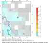
- Did you feel it? Report shaking and damage at your location. You can also view a map displaying accumulated data from your report and others.
Earthquake Summary


The following is a release by the United States Geological Survey, National Earthquake Information Center: An earthquake occurred 230 km (140 miles) SE of Hotan, Xinjiang or 3105 km (1930 miles) W of Beijing, China at 3:33 PM MST, Mar 20, 2008 (Mar 21 at 6:33 AM local time in China). The magnitude and location may be revised when additional data and further analysis results are available.
Felt Reports
Felt strongly and displaced 46,594 people. Up to 2,200 houses were damaged or flattened in Yutian, Qira and Lop. Four houses collapsed at Pulu.
Tectonic Summary
The earthquake occurred as a result of normal faulting in the tectonically complex region of the northern Tibetan Plateau. This earthquake occurred several hundred kilometers north of the convergent India-Eurasia plate boundary, where the Indian Plate is moving northwards with respect to Eurasia at a rate of approximately 46 mm/yr. This convergence drives the uplift of the Himalaya Mountains, at a rate of approximately 10 mm/yr, and the Tibetan Plateau, which is an extremely broad region of thickened and uplifted crust sitting above 4.5-5.0 km.
The uplifted Tibetan Plateau is spreading to the east and, as a result, is an area of east-west extension and eastward crustal motion within a larger region of generally north-south convergence. The Xinjiang-Xizang earthquake likely reflects the interplay amongst these major tectonic forces, dominated in this location by east-west extension. The eastward motion of Tibet, with respect to Eurasia further north, is accommodated in part by the large intra-continental Altyn Tagh and Kunlun strike-slip fault systems. The March 20, 2008 event is one of the largest known historical earthquakes to have occurred in the northern Tibetan Plateau west of the Kunlun Fault System. In 1996, a 6.9Mw earthquake occurred approximately 300 km further west.
Earthquake Maps


Scientific & Technical Information

- Preliminary Earthquake Report
- U.S. Geological Survey, National Earthquake Information Center:
World Data Center for Seismology, Denver
