
 Feeds & Data
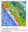
Magnitude 7.0 - KEPULAUAN MENTAWAI REGION, INDONESIA
2008 February 25 08:36:35 UTC
Earthquake Details
| Magnitude | 7.0 |
|---|---|
| Date-Time |
|
| Location | 2.352°S, 100.018°E |
| Depth | 35 km (21.7 miles) set by location program |
| Region | KEPULAUAN MENTAWAI REGION, INDONESIA |
| Distances | 160 km (100 miles) SSW of Padang, Sumatra, Indonesia 295 km (185 miles) WNW of Bengkulu, Sumatra, Indonesia 635 km (395 miles) SSW of KUALA LUMPUR, Malaysia 855 km (530 miles) WNW of JAKARTA, Java, Indonesia |
| Location Uncertainty | horizontal +/- 8.5 km (5.3 miles); depth fixed by location program |
| Parameters | NST= 78, Nph= 78, Dmin=847 km, Rmss=1.28 sec, Gp= 50°, M-type=moment magnitude (Mw), Version=9 |
| Source |
|
| Event ID | us2008nwbg |
- This event has been reviewed by a seismologist.
- Did you feel it? Report shaking and damage at your location. You can also view a map displaying accumulated data from your report and others.
Earthquake Summary


The following is a release by the United States Geological Survey, National Earthquake Information Center: An earthquake occurred 160 km (100 miles) SSW of Padang, Sumatra, Indonesia and 855 km (530 miles) WNW of JAKARTA, Java, Indonesia at 1:36 AM MST, Feb 25, 2008 (3:36 PM local time in Indonesia). The magnitude and location may be revised when additional data and further analysis results are available. There have been no reports of damage.
Felt Reports
WP 7.3 (HDRA). Felt (III) at Pekanbaru. Also felt at Curup, Duri and Padang. Felt (III) at Johor Bahru, Malaysia. Also felt at George Town, Malaysia. Felt (III) at Singapore, Singapore.
Tectonic Summary
The magnitude 7.0 Kepulauan Mentawai, Indonesia, earthquake of February 25, 2008 occurred as the result of thrust faulting on the boundary between the Australia and Sunda plates. At the location of this earthquake, the Australia plate moves north-northeast with respect to the Sunda plate at a velocity of about 60 mm/year. The direction of relative plate motion is oblique to the orientation of the plate boundary offshore of the west coast of Sumatra. The component of plate-motion perpendicular to the boundary is accommodated by thrust faulting on the offshore plate-boundary, with the Australia plate subducting beneath the Sunda plate. Much of the component of plate motion parallel to the plate boundary is accommodated by strike-skip faulting on the Sumatra fault, which is inland on Sumatra proper.
This earthquake continues an episode of unusually high earthquake activity that has impacted Sumatra and vicinity in recent years. Previous earthquakes in the series of shocks include the Sumatra-Andaman Islands earthquake of December 26, 2004 (M 9.1), the Nias earthquake of March 28, 2005 (M 8.6), and the southern Sumatra earthquakes of September 12, 2007 (M 8.4 and 7.9). The earthquake of February 25, 2008, occurred within the broad section of the Sumatra subduction zone that was spanned by aftershocks of the southern Sumatra earthquakes of September 12, 2007.
Earthquake Information for Asia
Earthquake Information for Indonesia
 Tsunami Information
- NOAA West Coast & Alaska Tsunami Warning Center
- NOAA Pacific Tsunami Warning Center
- Tsunami Information Links
The earthquake locations and magnitudes cited in these NOAA tsunami bulletins are very preliminary and may be superceded by USGS locations and magnitudes computed using more extensive data sets.
Earthquake Maps


Scientific & Technical Information

- Preliminary Earthquake Report
- U.S. Geological Survey, National Earthquake Information Center:
World Data Center for Seismology, Denver
