
Magnitude 6.7 - NEW BRITAIN REGION, PAPUA NEW GUINEA
2006 October 17 01:25:12 UTC
Earthquake Details
| Magnitude | 6.7 |
|---|---|
| Date-Time |
= Coordinated Universal Time = local time at epicenter |
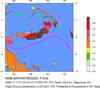
| Location | 5.846°S, 151.010°E |
| Depth | 32 km (19.9 miles) set by location program |
| Region | NEW BRITAIN REGION, PAPUA NEW GUINEA |
| Distances | 100 km (60 miles) ESE of Kimbe, New Britain, PNG 165 km (105 miles) ENE of Kandrian, New Britain, PNG 575 km (360 miles) NE of PORT MORESBY, Papua New Guinea 2400 km (1490 miles) N of BRISBANE, Queensland, Australia |
| Location Uncertainty | horizontal +/- 5.1 km (3.2 miles); depth fixed by location program |
| Parameters | Nst=215, Nph=215, Dmin=578.2 km, Rmss=0.9 sec, Gp= 22°, M-type=teleseismic moment magnitude (Mw), Version=6 |
| Source | USGS NEIC (WDCS-D) |
| Event ID | ustyac |
- This event has been reviewed by a seismologist.
Did you feel it?
Report shaking and damage at your location. You can also view a map displaying accumulated data from your report and others.
Earthquake Summary


Felt Reports
Felt at Kimbe, Kokopo and Rabaul.
 Tsunami Information
- West Coast & Alaska Tsunami Warning Center
- Pacific Tsunami Warning Center
- Recent Tsunamis
- Tsunami Information Links
The earthquake locations and magnitudes cited in these bulletins are very preliminary, and may disagree with the more accurate USGS locations and magnitudes computed using more extensive data sets.


 Historic Moment Tensor Solutions
- Preliminary Earthquake Report
- U.S. Geological Survey, National Earthquake Information Center
World Data Center for Seismology, Denver
