
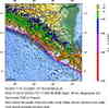
Magnitude 7.0 - NEAR THE COAST OF NICARAGUA
2004 October 9 21:26:53 UTC
Earthquake Details
| Magnitude | 7.0 |
|---|---|
| Date-Time |
= Coordinated Universal Time = local time at epicenter |
| Location | 11.422°N, 86.665°W |
| Depth | 35 km (21.7 miles) set by location program |
| Region | NEAR THE COAST OF NICARAGUA |
| Distances |
85 km (50 miles) SSW of MANAGUA, Nicaragua 90 km (55 miles) W of Rivas, Nicaragua 95 km (60 miles) SW of Granada, Nicaragua 1605 km (1000 miles) ESE of MEXICO CITY, D.F., Mexico |
| Location Uncertainty | horizontal +/- 5.8 km; depth fixed by location program |
| Parameters | Nst=379, Nph=379, Dmin=224.5 km, Rmss=1.30 sec, Gp= 33.6°, M-type=teleseismic moment magnitude (Mw) |
| Source | USGS NEIC (WDCS-D) |
| Event ID | uspjcz |
- This event has been reviewed by a seismologist.
Did you feel it?
Report shaking and damage at your location. You can also view a map displaying accumulated data from your report and others.

Earthquake Maps

Earthquake Location


Did you feel it?
Report shaking and damage at your location. You can also view a map displaying accumulated data from your report and others.
 Historic Moment Tensor Solutions
- Preliminary Earthquake Report
- U.S. Geological Survey, National Earthquake Information Center
World Data Center for Seismology, Denver
