
Magnitude 3.8 - WYOMING
2004 August 29 18:49:44 UTC
Earthquake Details
| Magnitude | 3.8 |
|---|---|
| Date-Time |
= Coordinated Universal Time = local time at epicenter |
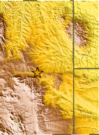
| Location | 42.886°N, 105.490°W |
| Depth | 5 km (3.1 miles) set by location program |
| Region | WYOMING |
| Distances |
15 km (10 miles) NNW of Douglas, Wyoming 65 km (40 miles) E of Casper, Wyoming 85 km (55 miles) SE of Midwest, Wyoming 205 km (125 miles) NNW of CHEYENNE, Wyoming |
| Location Uncertainty | horizontal +/- 8.6 km (5.3 miles); depth fixed by location program |
| Parameters | Nst= 27, Nph= 27, Dmin=180.1 km, Rmss=1.04 sec, Gp=140°, M-type=local magnitude (ML), Version=Q |
| Source | USGS NEIC (WDCS-D) |
| Event ID | usmtax |
- This event has been reviewed by a seismologist.
Did you feel it?
Report shaking and damage at your location. You can also view a map displaying accumulated data from your report and others.
Earthquake Maps

Earthquake Location

Did you feel it?
Report shaking and damage at your location. You can also view a map displaying accumulated data from your report and others.
- Preliminary Earthquake Report
- U.S. Geological Survey, National Earthquake Information Center
World Data Center for Seismology, Denver
